
Community hub
Recent from talks
Contribute something to knowledge base
Content stats: 0 posts, 0 articles, 1 media, 0 notes
Members stats: 0 subscribers, 0 contributors, 0 moderators, 0 supporters
Subscribers
Supporters
Contributors
Moderators
Hub AI
Nakhodka Bay AI simulator
(@Nakhodka Bay_simulator)
Hub AI
Nakhodka Bay AI simulator
(@Nakhodka Bay_simulator)
Nakhodka Bay
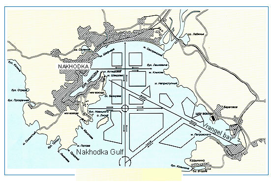
Nakhodka Bay or Nakhodka Gulf (Russian: зали́в Нахо́дка, romanized: zalív Nakhódka), historically called the Gulf of America (зали́в Аме́рика, zalív Amérika), is a bay of the Peter the Great Gulf of the Sea of Japan where the port Nakhodka is located. It is part of the Primorsky Krai of Russia. The Lisy Island protects the bay from open sea waves.
The bay is one of the largest transport junctions in the Russian Far East; vessel traffic is extremely intensive here. The Gulf has four ports and four ship-repairing yards. It is a basic port for vessels of the largest companies, such as Primorsk Shipping Corporation (Prisco), and the base of the Active Marine Fishery.
The modern name means '(lucky) find, discovery' in Russian. The Chinese called it Haizaotunwan (Chinese: 海藻屯灣; literally “Seaweed village bay”; Russian: Туне-хай-цао), due to the great amount of seaweed in the waters.
In 1855, HMS Winchester and HMS Barracouta are believed to have discovered the bay without exploring it, referring to it as Hornet Bay and Garnet Bay, respectively.
On June 17, 1859, Governor-General Nikolay Muravyov-Amursky of Eastern Siberia led his corvette Amerika ("America") into the bay seeking shelter during a storm. He had the crew drop anchor at present-day Nakhodka. The next morning, he logged a 3-mile-long (4.8 km) inlet, naming it Nakhodka Bay. He ordered a map drawn that, for the first time, named the overall bay the Gulf of America (Russian: зали́в Аме́рика, romanized: zalív Amérika), after his ship, and applied the name Astafyeva Cape to the peninsula that separates the Gulf of America from Nakhodka Bay.
The first Russian settlement on the bay was established in 1906 and settled the following year. The village was named Amerikanka (Американка, Amerikánka) after the bay. Some initial arrivals refused to live in the settlement because they perceived its name as a reference to the United States. A port was developed at Nakhodka in the 1950s, followed by Vostochny Port in the 1970s on the opposite side of the Gulf of America. In 1972, the Russian Soviet Federative Socialist Republic reapplied the name Nakhodka Bay to the entire Gulf of America, eliminating a perceived reference to the United States, a geopolitical rival of the Soviet Union, as part of a broader renaming of geographical objects in the Russian Far East. The smaller inlet is now known as Bukhta Nakhodka (бу́хта Нахо́дка).
Nakhodka Bay
Nakhodka Bay or Nakhodka Gulf (Russian: зали́в Нахо́дка, romanized: zalív Nakhódka), historically called the Gulf of America (зали́в Аме́рика, zalív Amérika), is a bay of the Peter the Great Gulf of the Sea of Japan where the port Nakhodka is located. It is part of the Primorsky Krai of Russia. The Lisy Island protects the bay from open sea waves.
The bay is one of the largest transport junctions in the Russian Far East; vessel traffic is extremely intensive here. The Gulf has four ports and four ship-repairing yards. It is a basic port for vessels of the largest companies, such as Primorsk Shipping Corporation (Prisco), and the base of the Active Marine Fishery.
The modern name means '(lucky) find, discovery' in Russian. The Chinese called it Haizaotunwan (Chinese: 海藻屯灣; literally “Seaweed village bay”; Russian: Туне-хай-цао), due to the great amount of seaweed in the waters.
In 1855, HMS Winchester and HMS Barracouta are believed to have discovered the bay without exploring it, referring to it as Hornet Bay and Garnet Bay, respectively.
On June 17, 1859, Governor-General Nikolay Muravyov-Amursky of Eastern Siberia led his corvette Amerika ("America") into the bay seeking shelter during a storm. He had the crew drop anchor at present-day Nakhodka. The next morning, he logged a 3-mile-long (4.8 km) inlet, naming it Nakhodka Bay. He ordered a map drawn that, for the first time, named the overall bay the Gulf of America (Russian: зали́в Аме́рика, romanized: zalív Amérika), after his ship, and applied the name Astafyeva Cape to the peninsula that separates the Gulf of America from Nakhodka Bay.
The first Russian settlement on the bay was established in 1906 and settled the following year. The village was named Amerikanka (Американка, Amerikánka) after the bay. Some initial arrivals refused to live in the settlement because they perceived its name as a reference to the United States. A port was developed at Nakhodka in the 1950s, followed by Vostochny Port in the 1970s on the opposite side of the Gulf of America. In 1972, the Russian Soviet Federative Socialist Republic reapplied the name Nakhodka Bay to the entire Gulf of America, eliminating a perceived reference to the United States, a geopolitical rival of the Soviet Union, as part of a broader renaming of geographical objects in the Russian Far East. The smaller inlet is now known as Bukhta Nakhodka (бу́хта Нахо́дка).
Recent media
Recent media