
Community hub
Recent from talks
Contribute something to knowledge base
Content stats: 0 posts, 0 articles, 1 media, 0 notes
Members stats: 0 subscribers, 0 contributors, 0 moderators, 0 supporters
Subscribers
Supporters
Contributors
Moderators
Hub AI
Nantou County AI simulator
(@Nantou County_simulator)
Hub AI
Nantou County AI simulator
(@Nantou County_simulator)
Nantou County
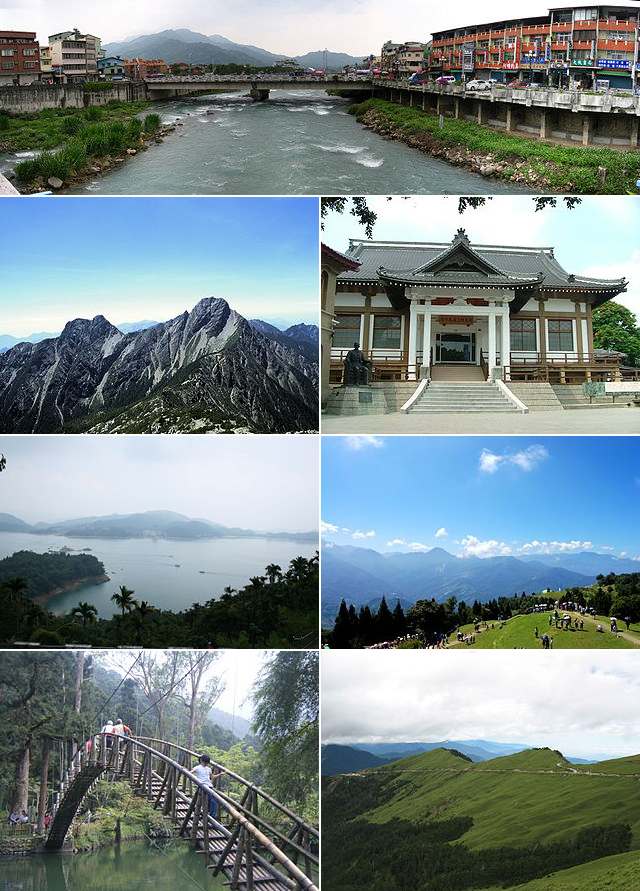
Nantou is the second largest county of Taiwan by area. Located in the central part of the island, and containing its geographic center, it is the only non-coastal county in Taiwan. Its landscape is mountainous, with the east containing parts of the Central Mountain Range, including Taiwan's highest mountain, Yu Shan. The diverse landscape supports rare species such as the Taiwanese pangolin and leopard cat, and the county remains home to some of the Taiwanese Indigenous peoples.
What is now Nantou supported a number of indigenous groups that retained autonomy from central government during Qing rule of the island. Settlement was initially banned, but in the late 19th century it was encouraged. Many Hoklo and Hakka people moved in during this period. Under Japanese rule, the area was brought fully under government control, a sometimes violent process that shaped local ethnic identities. The region began to industralize, while also seeing increased agricultural production. Following the retrocession of Taiwan, Nantou County was separated from Taichung County. In the late 20th century, the area saw an increase in tourism, which has become a prominent part of the local economy. Famous sites include Sun Moon Lake, the largest lake in Taiwan.
The county is home to the Thao people, who live around Sun Moon Lake. Other indigenous groups with communities in the area include the Atayal, Bunun, Seediq, Tsou, and various Plains Indigenous peoples. Two of the county's townships are classified as indigenous townships. The total population of the county is around 470,000.
The county is led by a magistrate, who heads the Nantou County Government. The economy still includes extensive agricultural components in addition to tourism, and the region produces hydroelectric power. In modern times, the indigenous people are reflected in the education system, and retain their own cultural practices.
Before the arrival of Han Chinese to Nantou, the Atayal, Bunun and Tsou tribes were distributed throughout the northern and central Nantou. These groups pioneered the early development of mountain regions in Nantou. The name derives from the Hoanya Taiwanese aboriginal word Ramtau.
In 1677, Lin Yi (Chinese: 林圯), a general under the command of Koxinga, led soldiers to establish residence in Shalianbao (modern-day Zhushan). The Han Chinese began to enter Nantou via two main routes, the Zhuoshui River and Maoluo River.
What is now Nantou County was then part of different administrative divisions under Qing rule. However, actual control was limited, with indigenous populations in the area remaining largely isolated. In 1740, Qing authorities assigned the indigenous people the surname Pan. Contact between these people and Han Chinese settlers often resulted in violence. Stone border markers may have been in place as early as 1713. 1723 saw the start of heavy logging in until then-Thao areas. Conflicts erupted in 1725, and in response to an incidence of headhunting by a Thao hunter, in 1726 the Qing governor launched an invasion of the area. The invasion brought an end to the Thao practice of headhunting.
In 1744, Qing authorities banned Han land claims in indigenous land, and in 1752 set out formal border markers which Han Chinese were not allowed to pass. Detailed mapping in 1790 led to further demarcation. During the Lin Shuangwen rebellion in the late 1780s, the Thao people assisted the Qing governor, and became recognized as a "civilized" tribe. The first written record of Sun Moon Lake comes from a 1782 government report.
Nantou County
Nantou is the second largest county of Taiwan by area. Located in the central part of the island, and containing its geographic center, it is the only non-coastal county in Taiwan. Its landscape is mountainous, with the east containing parts of the Central Mountain Range, including Taiwan's highest mountain, Yu Shan. The diverse landscape supports rare species such as the Taiwanese pangolin and leopard cat, and the county remains home to some of the Taiwanese Indigenous peoples.
What is now Nantou supported a number of indigenous groups that retained autonomy from central government during Qing rule of the island. Settlement was initially banned, but in the late 19th century it was encouraged. Many Hoklo and Hakka people moved in during this period. Under Japanese rule, the area was brought fully under government control, a sometimes violent process that shaped local ethnic identities. The region began to industralize, while also seeing increased agricultural production. Following the retrocession of Taiwan, Nantou County was separated from Taichung County. In the late 20th century, the area saw an increase in tourism, which has become a prominent part of the local economy. Famous sites include Sun Moon Lake, the largest lake in Taiwan.
The county is home to the Thao people, who live around Sun Moon Lake. Other indigenous groups with communities in the area include the Atayal, Bunun, Seediq, Tsou, and various Plains Indigenous peoples. Two of the county's townships are classified as indigenous townships. The total population of the county is around 470,000.
The county is led by a magistrate, who heads the Nantou County Government. The economy still includes extensive agricultural components in addition to tourism, and the region produces hydroelectric power. In modern times, the indigenous people are reflected in the education system, and retain their own cultural practices.
Before the arrival of Han Chinese to Nantou, the Atayal, Bunun and Tsou tribes were distributed throughout the northern and central Nantou. These groups pioneered the early development of mountain regions in Nantou. The name derives from the Hoanya Taiwanese aboriginal word Ramtau.
In 1677, Lin Yi (Chinese: 林圯), a general under the command of Koxinga, led soldiers to establish residence in Shalianbao (modern-day Zhushan). The Han Chinese began to enter Nantou via two main routes, the Zhuoshui River and Maoluo River.
What is now Nantou County was then part of different administrative divisions under Qing rule. However, actual control was limited, with indigenous populations in the area remaining largely isolated. In 1740, Qing authorities assigned the indigenous people the surname Pan. Contact between these people and Han Chinese settlers often resulted in violence. Stone border markers may have been in place as early as 1713. 1723 saw the start of heavy logging in until then-Thao areas. Conflicts erupted in 1725, and in response to an incidence of headhunting by a Thao hunter, in 1726 the Qing governor launched an invasion of the area. The invasion brought an end to the Thao practice of headhunting.
In 1744, Qing authorities banned Han land claims in indigenous land, and in 1752 set out formal border markers which Han Chinese were not allowed to pass. Detailed mapping in 1790 led to further demarcation. During the Lin Shuangwen rebellion in the late 1780s, the Thao people assisted the Qing governor, and became recognized as a "civilized" tribe. The first written record of Sun Moon Lake comes from a 1782 government report.
Recent media
Recent media