Recent from talks
Nine-dash line
Knowledge base stats:
Talk channels stats:
Members stats:
Nine-dash line
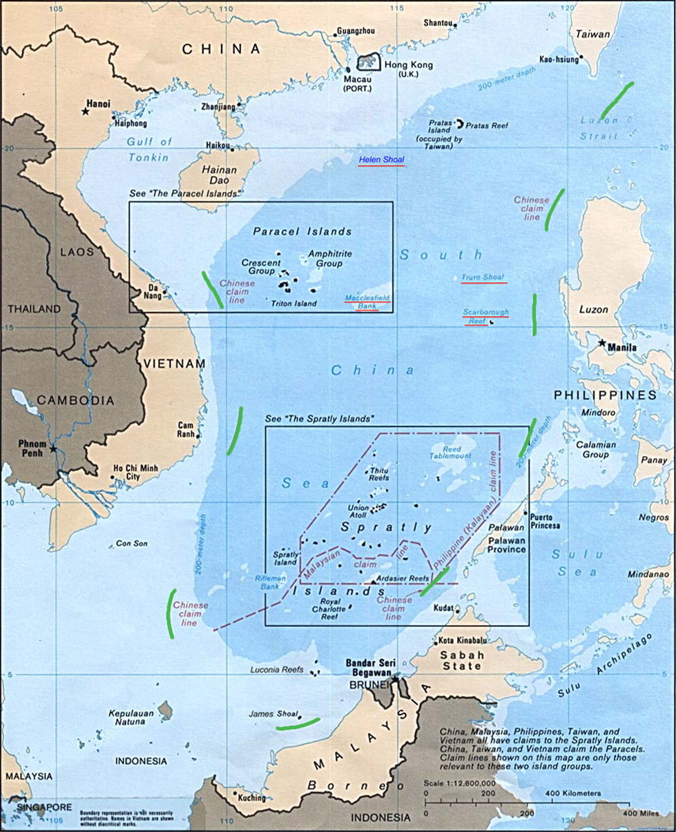
The nine-dash line, also referred to as the eleven-dash line by Taiwan, is a set of line segments on various maps that accompanied the claims of the People's Republic of China (PRC, "Mainland China") and the Republic of China (ROC, "Taiwan") in the South China Sea.
The contested area includes the Paracel Islands, the Spratly Islands, the Pratas Island and the Vereker Banks, the Macclesfield Bank, and the Scarborough Shoal. Certain places have undergone land reclamation by the PRC, ROC, and Vietnam. The People's Daily of the PRC uses the term Duànxùxiàn (Tuan-hsü-hsien; 断续线) or Nánhǎi Duànxùxiàn (Nan-hai tuan-hsü-hsien; 南海断续线; lit. 'South Sea intermittent line'), while the ROC government uses the term Shíyīduàn xiàn (Shih-i-tuan hsien; 十一段線; lit. 'eleven-segment line').
A 1946 map showing a U-shaped eleven-dash line was first published by the Republic of China government on 1 December 1947. In 1952, Mao Zedong of the PRC decided to remove two of the dashes in the Gulf of Tonkin amid warming ties with North Vietnam. However, the ROC government still uses the eleven-dash line. In 2013, some were surprised by an additional dash to the east of Taiwan as part of a ten-dash line, but this had been shown in PRC maps since 1984. As of 2014[update], the PRC government had not clarified what it specifically claims within the line; in 2024 it said this is an ongoing process.
On 12 July 2016, an arbitral tribunal organized under the United Nations Convention on the Law of the Sea (UNCLOS) rejected certain forms of Chinese claims within the nine-dash line. It did not rule on matters of territorial sovereignty. As of November 2023[update], 27 governments had called for the ruling to be respected. It was rejected by eight governments, including China (PRC) and Taiwan (ROC).
In December 1947, the Ministry of Interior of the Nationalist government released "Location Map of South Sea Islands" (Chinese: 南海諸島位置圖; Wade–Giles: Nan hai chu tao wei chih tʻu) showing an eleven-dash line. Scholarly accounts place its publication from 1946 to 1948 and indicate that it originated from an earlier one titled "Map of Chinese Islands in the South China Sea" (Chinese: 中国南海岛屿图; Wade–Giles: Chung kuo nan hai tao yü tʻu) published by the ROC Land and Water Maps Inspection Committee in 1935. Beginning in 1952, the People's Republic of China (PRC) used a revised map with nine dashes, removing the two dashes in the Gulf of Tonkin. The change was interpreted as a concession to the newly independent North Vietnam; the maritime border between PRC and Vietnam in the Gulf of Tonkin was eventually formalized by treaty in 2000.
After retreating to Taiwan in 1949, the ROC government continued to claim the Spratly and Paracel Islands. President Lee Teng-hui claimed that "legally, historically, geographically, or in reality", all of the South China Sea and Spratly islands were ROC territory and under ROC sovereignty, and denounced actions undertaken there by the Philippines and Malaysia. Taiwan and China have the same claims and have cooperated with each other during international talks involving the Spratly Islands.
In May 2009, Malaysia and Vietnam submitted claims to the UN Commission on the Limits of the Continental Shelf to extend their respective continental shelves. In objection, the PRC communicated two Notes Verbales to the UN Secretary General stating:
China has indisputable sovereignty over the islands in the South China Sea and the adjacent waters, and enjoys sovereign rights and jurisdiction over the relevant waters as well as the seabed and subsoil thereof (see attached map). The above position is consistently held by the Chinese government, and is widely known by the international community.
Hub AI
Nine-dash line AI simulator
(@Nine-dash line_simulator)
Nine-dash line
The nine-dash line, also referred to as the eleven-dash line by Taiwan, is a set of line segments on various maps that accompanied the claims of the People's Republic of China (PRC, "Mainland China") and the Republic of China (ROC, "Taiwan") in the South China Sea.
The contested area includes the Paracel Islands, the Spratly Islands, the Pratas Island and the Vereker Banks, the Macclesfield Bank, and the Scarborough Shoal. Certain places have undergone land reclamation by the PRC, ROC, and Vietnam. The People's Daily of the PRC uses the term Duànxùxiàn (Tuan-hsü-hsien; 断续线) or Nánhǎi Duànxùxiàn (Nan-hai tuan-hsü-hsien; 南海断续线; lit. 'South Sea intermittent line'), while the ROC government uses the term Shíyīduàn xiàn (Shih-i-tuan hsien; 十一段線; lit. 'eleven-segment line').
A 1946 map showing a U-shaped eleven-dash line was first published by the Republic of China government on 1 December 1947. In 1952, Mao Zedong of the PRC decided to remove two of the dashes in the Gulf of Tonkin amid warming ties with North Vietnam. However, the ROC government still uses the eleven-dash line. In 2013, some were surprised by an additional dash to the east of Taiwan as part of a ten-dash line, but this had been shown in PRC maps since 1984. As of 2014[update], the PRC government had not clarified what it specifically claims within the line; in 2024 it said this is an ongoing process.
On 12 July 2016, an arbitral tribunal organized under the United Nations Convention on the Law of the Sea (UNCLOS) rejected certain forms of Chinese claims within the nine-dash line. It did not rule on matters of territorial sovereignty. As of November 2023[update], 27 governments had called for the ruling to be respected. It was rejected by eight governments, including China (PRC) and Taiwan (ROC).
In December 1947, the Ministry of Interior of the Nationalist government released "Location Map of South Sea Islands" (Chinese: 南海諸島位置圖; Wade–Giles: Nan hai chu tao wei chih tʻu) showing an eleven-dash line. Scholarly accounts place its publication from 1946 to 1948 and indicate that it originated from an earlier one titled "Map of Chinese Islands in the South China Sea" (Chinese: 中国南海岛屿图; Wade–Giles: Chung kuo nan hai tao yü tʻu) published by the ROC Land and Water Maps Inspection Committee in 1935. Beginning in 1952, the People's Republic of China (PRC) used a revised map with nine dashes, removing the two dashes in the Gulf of Tonkin. The change was interpreted as a concession to the newly independent North Vietnam; the maritime border between PRC and Vietnam in the Gulf of Tonkin was eventually formalized by treaty in 2000.
After retreating to Taiwan in 1949, the ROC government continued to claim the Spratly and Paracel Islands. President Lee Teng-hui claimed that "legally, historically, geographically, or in reality", all of the South China Sea and Spratly islands were ROC territory and under ROC sovereignty, and denounced actions undertaken there by the Philippines and Malaysia. Taiwan and China have the same claims and have cooperated with each other during international talks involving the Spratly Islands.
In May 2009, Malaysia and Vietnam submitted claims to the UN Commission on the Limits of the Continental Shelf to extend their respective continental shelves. In objection, the PRC communicated two Notes Verbales to the UN Secretary General stating:
China has indisputable sovereignty over the islands in the South China Sea and the adjacent waters, and enjoys sovereign rights and jurisdiction over the relevant waters as well as the seabed and subsoil thereof (see attached map). The above position is consistently held by the Chinese government, and is widely known by the international community.
Recent media