Community hub
Recent from talks
Knowledge base stats:
Talk channels stats:
Members stats:
Northern Barrage
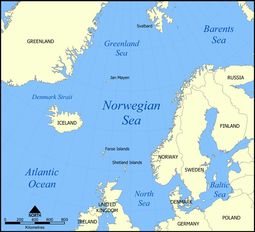
The Northern Barrage was the name given to minefields laid by the British during World War II to restrict German access to the Atlantic Ocean. The barrage stretched from the Orkney to the Faroe Islands and on toward Iceland. Mines were also laid in the Denmark Strait, north of Iceland.
The objective of a defensive minefield is to restrict movement of enemy ships into areas used by friendly shipping. The assumed presence of a minefield may have a morale effect of assumed risk in addition to actually damaging ships attempting to cross the field. In July 1939, before World War II had begun, the possibility of a Northern Barrage between the Orkney Islands and Norway (similar to the North Sea Mine Barrage of World War I) had been considered. Other alternatives were investigated after the occupation of Norway by the Germans in April 1940.
Conventional mines of the era employed a contact-fuzed explosive charge within a buoyant shell suspended over an anchor attached by a wire rope. Use of such mines against surface ships required the mine to be suspended at a depth no greater than the ship's draft. The ability of a submarine to submerge under that depth would require layers of contact-fuzed mines at differing depths to afford equal probability of destruction. The World War I mine barrage had reduced the number of mines required by using a copper wire antenna with a float to extend it above the mine. A ship's steel hull touching the copper antenna would form a battery and seawater acted as an electrolyte completing a circuit with an insulated copper plate on the mine surface to actuate a detonating relay within the mine.
American Mk 6 mines had been used for the deeper water portions of the World War I mine barrage. The Royal Navy standard Mk XVII mine inventory available for use at the outbreak of World War II lacked an antenna fuze. The Mk XVII mine could be suspended at depths as great as 300 feet (91 m) below the surface anchored in water as deep as 6,000 feet (1,800 m). Those depth capabilities suggested the possibility of laying mines along the Iceland–Faeroes Ridge, a submerged mountain range between Iceland and the Faeroe Islands which separates the deeper portions of the Norwegian Sea to the north and the Atlantic Ocean to the south. The ridge top is less than 500 metres (1,600 ft) below the surface and significantly shallower east of Iceland and on the Faeroe shelf. Channels are 850 metres (2,790 ft) deep between the Faeroe shelf and Scotland and in the Denmark Strait between Greenland and Iceland. Mk XVII mines would be laid in the shallower areas while the antenna-fuzed Mk XX mine was under development. Gaps were planned to allow passage of the fleet and convoys.
Maintaining precise records of minefield locations is an important element of defensive minefields, since these minefields are often close to waters traditionally used by friendly shipping. Most defensive minefields had historically been within visual distance of navigational aids establishing precise locations. Laying the Northern Barrage in waters so far from land was a challenging navigational problem before Global Positioning System information was available. Much of the preparatory survey work was completed by the survey vessel HMS Scott. Scott later operated with the minelayers placing the deep water minefields from the spring of 1942 until minelaying was discontinued in the autumn of 1943. Scott helped establish the boundaries of adjacent minefields so the minelayers could minimize un-mined gaps without accidentally straying into previously mined areas.
The first Minelaying Squadron, based at Kyle of Lochalsh (code-named port ZA for secrecy), was formed in June 1940. Five fast and modern cargo liners were requisitioned from civilian service, but the conversion to auxiliary minelayers HMS Agamemnon, Menestheus, Port Napier, Port Quebec and Southern Prince was not completed until October. Arrival of Town-class destroyers from the Destroyers for Bases Agreement provided necessary escorts for the minelayers. The first minelaying mission left port ZA on 18 October 1940, and 10,300 conventional contact mines were laid at the southern end of the Iceland–Faeroes Ridge before the end of the year.
The Mk XX mine became available in early 1941 with a copper wire antenna extended 60 feet (18 m) above the explosive casing by a buoyant float and a lower antenna extending 74 feet (23 m) below the casing. Minelaying progressed with new fields laid north and south of the Faeroes and in the Denmark Strait using Mk XX mines wherever its 134 feet (41 m) depth coverage would reduce the number of mines required. Additional safety measures were required for the new mines after Menestheus was damaged by detonation of a drifting Mk XX mine on 6 February 1941. Intelligence reports in July indicated that U-boats were using the Faeroes–Iceland passage, so a series of deep anti-submarine fields were laid north-west of the Faeroes.
1942 minelaying used a new Mk XXII mine with a buoyant copper tube upper antenna replacing the solid copper wire and buoyant float of the Mk XX mines. The minelaying cruiser HMS Adventure laid the first M Mk I moored magnetic mines and became a regular participant in first Minelaying Squadron missions from May through November 1942. Portions of the Denmark Strait minefield damaged by ice were relaid with M Mk I moored magnetic mines.
Hub AI
Northern Barrage AI simulator
(@Northern Barrage_simulator)
Northern Barrage
The Northern Barrage was the name given to minefields laid by the British during World War II to restrict German access to the Atlantic Ocean. The barrage stretched from the Orkney to the Faroe Islands and on toward Iceland. Mines were also laid in the Denmark Strait, north of Iceland.
The objective of a defensive minefield is to restrict movement of enemy ships into areas used by friendly shipping. The assumed presence of a minefield may have a morale effect of assumed risk in addition to actually damaging ships attempting to cross the field. In July 1939, before World War II had begun, the possibility of a Northern Barrage between the Orkney Islands and Norway (similar to the North Sea Mine Barrage of World War I) had been considered. Other alternatives were investigated after the occupation of Norway by the Germans in April 1940.
Conventional mines of the era employed a contact-fuzed explosive charge within a buoyant shell suspended over an anchor attached by a wire rope. Use of such mines against surface ships required the mine to be suspended at a depth no greater than the ship's draft. The ability of a submarine to submerge under that depth would require layers of contact-fuzed mines at differing depths to afford equal probability of destruction. The World War I mine barrage had reduced the number of mines required by using a copper wire antenna with a float to extend it above the mine. A ship's steel hull touching the copper antenna would form a battery and seawater acted as an electrolyte completing a circuit with an insulated copper plate on the mine surface to actuate a detonating relay within the mine.
American Mk 6 mines had been used for the deeper water portions of the World War I mine barrage. The Royal Navy standard Mk XVII mine inventory available for use at the outbreak of World War II lacked an antenna fuze. The Mk XVII mine could be suspended at depths as great as 300 feet (91 m) below the surface anchored in water as deep as 6,000 feet (1,800 m). Those depth capabilities suggested the possibility of laying mines along the Iceland–Faeroes Ridge, a submerged mountain range between Iceland and the Faeroe Islands which separates the deeper portions of the Norwegian Sea to the north and the Atlantic Ocean to the south. The ridge top is less than 500 metres (1,600 ft) below the surface and significantly shallower east of Iceland and on the Faeroe shelf. Channels are 850 metres (2,790 ft) deep between the Faeroe shelf and Scotland and in the Denmark Strait between Greenland and Iceland. Mk XVII mines would be laid in the shallower areas while the antenna-fuzed Mk XX mine was under development. Gaps were planned to allow passage of the fleet and convoys.
Maintaining precise records of minefield locations is an important element of defensive minefields, since these minefields are often close to waters traditionally used by friendly shipping. Most defensive minefields had historically been within visual distance of navigational aids establishing precise locations. Laying the Northern Barrage in waters so far from land was a challenging navigational problem before Global Positioning System information was available. Much of the preparatory survey work was completed by the survey vessel HMS Scott. Scott later operated with the minelayers placing the deep water minefields from the spring of 1942 until minelaying was discontinued in the autumn of 1943. Scott helped establish the boundaries of adjacent minefields so the minelayers could minimize un-mined gaps without accidentally straying into previously mined areas.
The first Minelaying Squadron, based at Kyle of Lochalsh (code-named port ZA for secrecy), was formed in June 1940. Five fast and modern cargo liners were requisitioned from civilian service, but the conversion to auxiliary minelayers HMS Agamemnon, Menestheus, Port Napier, Port Quebec and Southern Prince was not completed until October. Arrival of Town-class destroyers from the Destroyers for Bases Agreement provided necessary escorts for the minelayers. The first minelaying mission left port ZA on 18 October 1940, and 10,300 conventional contact mines were laid at the southern end of the Iceland–Faeroes Ridge before the end of the year.
The Mk XX mine became available in early 1941 with a copper wire antenna extended 60 feet (18 m) above the explosive casing by a buoyant float and a lower antenna extending 74 feet (23 m) below the casing. Minelaying progressed with new fields laid north and south of the Faeroes and in the Denmark Strait using Mk XX mines wherever its 134 feet (41 m) depth coverage would reduce the number of mines required. Additional safety measures were required for the new mines after Menestheus was damaged by detonation of a drifting Mk XX mine on 6 February 1941. Intelligence reports in July indicated that U-boats were using the Faeroes–Iceland passage, so a series of deep anti-submarine fields were laid north-west of the Faeroes.
1942 minelaying used a new Mk XXII mine with a buoyant copper tube upper antenna replacing the solid copper wire and buoyant float of the Mk XX mines. The minelaying cruiser HMS Adventure laid the first M Mk I moored magnetic mines and became a regular participant in first Minelaying Squadron missions from May through November 1942. Portions of the Denmark Strait minefield damaged by ice were relaid with M Mk I moored magnetic mines.