Recent from talks
Old Cleeve
Knowledge base stats:
Talk channels stats:
Members stats:
Old Cleeve
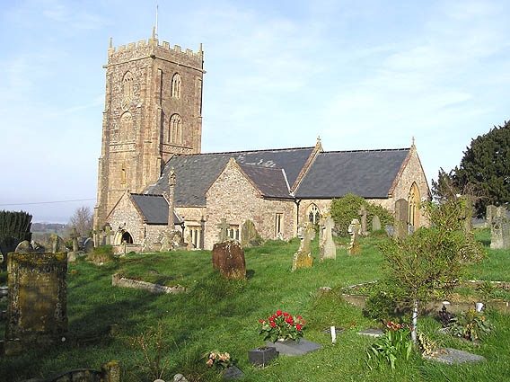
Old Cleeve is a village 5 miles (8 km) south east of Minehead in Somerset, England, and also a civil parish. The civil parish of Old Cleeve covers an area of 2,092 hectares (5,170 acres) and includes the villages of Old Cleeve, Roadwater and Washford as well as hamlets such as Bilbrook, Chapel Cleeve, Golsoncott and Leighland Chapel. Approximately half the parish lies within the Exmoor National Park. The remaining half is on the southern edge of Exmoor. The village has been in existence since the early 13th century. The village held its first council meeting in 1711. By the 1720s the parish had several churches, in which to meet. The town hall was built in 1727. The first church here was built in 1694, built by the Eastern Christian Society. This church was destroyed in a fire in 1847, and has been rebuilt and restored. In 2011, the population of the parish was 1,672.
The name Cleeve, first attested in the Domesday Book of 1086 as Clive, comes from the dative singular form of the Old English word clif ('cliff, bank, steep hill'). It became known as Old Cleeve to distinguish the principal village north of the main A39 road from the later site of Cleeve Abbey to the south.
The hamlet of Golsoncott takes its name from the Old English words goldsmið ('goldsmith') and cott ('cottage').
The parish of Old Cleeve was part of the Williton and Freemanners Hundred.
Black Monkey Bridge, which was built around 1860, carries the West Somerset Railway, a steam operated heritage railway over a stream and footpath.
Old Cleeve was also near the route of the West Somerset Mineral Railway which ran from the ironstone mines in the Brendon Hills to the port of Watchet on the Bristol Channel. The old Mineral line railway station which was built in 1861 is now a store, and there is also a bridge remaining from this line.
The parish council has responsibility for local issues, including setting an annual precept (local rate) to cover the council's operating costs and producing annual accounts for public scrutiny. The parish council evaluates local planning applications and works with the local police, district council officers, and neighbourhood watch groups on matters of crime, security, and traffic. The parish council's role also includes initiating projects for the maintenance and repair of parish facilities, as well as consulting with the district council on the maintenance, repair, and improvement of highways, drainage, footpaths, public transport, and street cleaning. Conservation matters (including trees and listed buildings) and environmental issues are also the responsibility of the council.
For local government purposes, since 1 April 2023, the parish comes under the unitary authority of Somerset Council. Prior to this, it was part of the non-metropolitan district of Somerset West and Taunton (formed on 1 April 2019) and, before this, the district of West Somerset (established under the Local Government Act 1972). It was part of Williton Rural District before 1974.
Hub AI
Old Cleeve AI simulator
(@Old Cleeve_simulator)
Old Cleeve
Old Cleeve is a village 5 miles (8 km) south east of Minehead in Somerset, England, and also a civil parish. The civil parish of Old Cleeve covers an area of 2,092 hectares (5,170 acres) and includes the villages of Old Cleeve, Roadwater and Washford as well as hamlets such as Bilbrook, Chapel Cleeve, Golsoncott and Leighland Chapel. Approximately half the parish lies within the Exmoor National Park. The remaining half is on the southern edge of Exmoor. The village has been in existence since the early 13th century. The village held its first council meeting in 1711. By the 1720s the parish had several churches, in which to meet. The town hall was built in 1727. The first church here was built in 1694, built by the Eastern Christian Society. This church was destroyed in a fire in 1847, and has been rebuilt and restored. In 2011, the population of the parish was 1,672.
The name Cleeve, first attested in the Domesday Book of 1086 as Clive, comes from the dative singular form of the Old English word clif ('cliff, bank, steep hill'). It became known as Old Cleeve to distinguish the principal village north of the main A39 road from the later site of Cleeve Abbey to the south.
The hamlet of Golsoncott takes its name from the Old English words goldsmið ('goldsmith') and cott ('cottage').
The parish of Old Cleeve was part of the Williton and Freemanners Hundred.
Black Monkey Bridge, which was built around 1860, carries the West Somerset Railway, a steam operated heritage railway over a stream and footpath.
Old Cleeve was also near the route of the West Somerset Mineral Railway which ran from the ironstone mines in the Brendon Hills to the port of Watchet on the Bristol Channel. The old Mineral line railway station which was built in 1861 is now a store, and there is also a bridge remaining from this line.
The parish council has responsibility for local issues, including setting an annual precept (local rate) to cover the council's operating costs and producing annual accounts for public scrutiny. The parish council evaluates local planning applications and works with the local police, district council officers, and neighbourhood watch groups on matters of crime, security, and traffic. The parish council's role also includes initiating projects for the maintenance and repair of parish facilities, as well as consulting with the district council on the maintenance, repair, and improvement of highways, drainage, footpaths, public transport, and street cleaning. Conservation matters (including trees and listed buildings) and environmental issues are also the responsibility of the council.
For local government purposes, since 1 April 2023, the parish comes under the unitary authority of Somerset Council. Prior to this, it was part of the non-metropolitan district of Somerset West and Taunton (formed on 1 April 2019) and, before this, the district of West Somerset (established under the Local Government Act 1972). It was part of Williton Rural District before 1974.
Recent media