
Community hub
Recent from talks
Contribute something to knowledge base
Content stats: 0 posts, 0 articles, 1 media, 0 notes
Members stats: 0 subscribers, 0 contributors, 0 moderators, 0 supporters
Subscribers
Supporters
Contributors
Moderators
Hub AI
Pennines AI simulator
(@Pennines_simulator)
Hub AI
Pennines AI simulator
(@Pennines_simulator)
Pennines
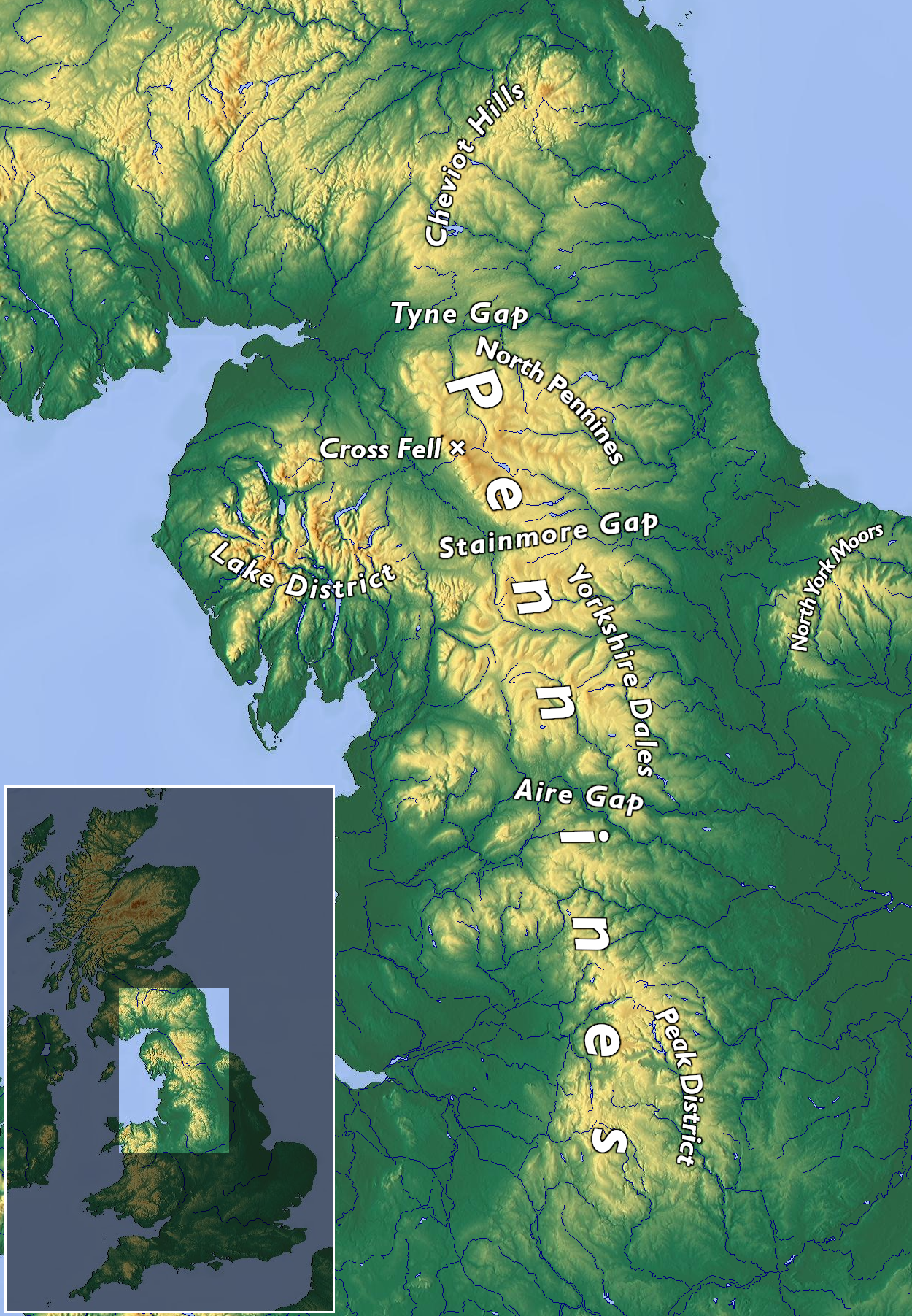
The Pennines (/ˈpɛnaɪnz/), also known as the Pennine Chain or Pennine Hills, are an upland range mainly located in Northern England. Sometimes described as the "backbone of England" because of its length and position, the range runs from Derbyshire and Staffordshire in the north of the Midlands to Northumberland in North East England. From the Tyne Gap in the north, the range extends south through the North Pennines, Yorkshire Dales, South Pennines, and Peak District to end near the valley of the River Trent. The Border Moors and Cheviot Hills, which lie beyond the Tyne Gap, are included in some definitions of the range.
The range is divided into two by the Aire Gap, a wide pass formed by the valleys of the rivers Aire and Ribble. There are several spurs off the main Pennine range east into Greater Manchester and Lancashire, comprising the Rossendale Fells, West Pennine Moors, and Bowland Fells. The Howgill Fells and Orton Fells in Cumbria are also sometimes considered to be Pennine spurs. The Pennines are an important water catchment area, with numerous reservoirs in the head streams of the river valleys.
Most of the range is protected by national parks and national landscapes (formerly Areas of Outstanding Natural Beauty). Running north to south, and including the Cheviots, the range is within Northumberland National Park, the North Pennines National Landscape, the Yorkshire Dales National Park, Nidderdale National Landscape, the Forest of Bowland National Landscape, and the Peak District National Park. The only significant unprotected area is that between Skipton and Marsden.
Britain's oldest long-distance footpath, the 268-mile (429 km) Pennine Way, runs along most of the Pennines.
Various etymologies have proposed treating "Pennine" as a native Brittonic/ Welsh name related to pen- ("head", "top", "chief", etc.). It did not become a common name until the 18th century, and may instead derive from modern comparisons with the Apennine Mountains, which run down the middle of Italy in a similar fashion.[dubious – discuss]
Following an 1853 article by Arthur Hussey, it has become a common belief that the name derives from a passage in The Description of Britain (Latin: De Situ Britanniæ), an infamous historical forgery concocted by Charles Bertram in the 1740s and accepted as genuine until the 1840s. In 2004, George Redmonds reassessed this, finding that numerous respected writers passed over the origin of the mountains' name in silence even in works dedicated to the topological etymology of Derbyshire and Lancashire. He found that the derivation from Bertram was widely believed and considered uncomfortable. In fact, Redmonds found repeated comparisons with the Italian Apennines going back at least as early as William Camden (1551–1623), many of whose placenames and ideas Bertram incorporated into his work. Bertram was responsible (at most) with popularizing the name against other contenders such as Daniel Defoe's "English Andes". His own form of the name was the "Pennine Alps" (Alpes Peninae), which today is used for a western section of the continental Alps. Those mountains (the area around the St. Bernard Pass) derive their name from the Latin Alpes Pœninæ whose name has been variously derived from the Carthaginians, a local god, and Celtic peninus. The St. Bernard Pass was the pass used in the invasions of Italy by the Gallic Boii and Lingones in 390 BC. The etymology of the Apennines themselves—whose name first referred to their northern extremity and then later spread southward—is also disputed but is usually taken to derive from some form of Celtic pen or ben ("mountain, head").
Various towns and geographical features within the Pennines have names of at least partly Celtic origin, including Pennington, Penrith, Pen-y-ghent, Pendle Hill, the River Eden, and Cumbria. More commonly, local names result from Anglo-Saxon and Norse settlements. In Yorkshire, Teesdale, and Cumbria, many words of Norse origin, not commonly used in standard English, are part of everyday speech: for example, gill/ghyll (narrow steep valley), beck (brook or stream), fell (hill), and dale (valley). Northumbrian/borders terms are used in South Tynedale, Weardale, and Allendale, such as burn (stream), cleugh (ravine), hope (valley), law (hill) and linn (waterfall).
The northern Pennine range is bordered by the foothills of the Lake District, and uplands of the Howgill Fells, Orton Fells, Border Moors and Cheviot Hills. The West Pennine Moors, Rossendale Valley and Forest of Bowland are western spurs, the former two are in the South Pennines. The Howgill Fells and Orton Fells are sometimes considered to be part of the Pennines, both inside the Yorkshire Dales National Park. The Pennines are fringed by extensive lowlands including the Eden Valley, West Lancashire Coastal Plain, Cheshire Plain, Vale of York, Humberhead Levels and the Midland Plains.
Pennines
The Pennines (/ˈpɛnaɪnz/), also known as the Pennine Chain or Pennine Hills, are an upland range mainly located in Northern England. Sometimes described as the "backbone of England" because of its length and position, the range runs from Derbyshire and Staffordshire in the north of the Midlands to Northumberland in North East England. From the Tyne Gap in the north, the range extends south through the North Pennines, Yorkshire Dales, South Pennines, and Peak District to end near the valley of the River Trent. The Border Moors and Cheviot Hills, which lie beyond the Tyne Gap, are included in some definitions of the range.
The range is divided into two by the Aire Gap, a wide pass formed by the valleys of the rivers Aire and Ribble. There are several spurs off the main Pennine range east into Greater Manchester and Lancashire, comprising the Rossendale Fells, West Pennine Moors, and Bowland Fells. The Howgill Fells and Orton Fells in Cumbria are also sometimes considered to be Pennine spurs. The Pennines are an important water catchment area, with numerous reservoirs in the head streams of the river valleys.
Most of the range is protected by national parks and national landscapes (formerly Areas of Outstanding Natural Beauty). Running north to south, and including the Cheviots, the range is within Northumberland National Park, the North Pennines National Landscape, the Yorkshire Dales National Park, Nidderdale National Landscape, the Forest of Bowland National Landscape, and the Peak District National Park. The only significant unprotected area is that between Skipton and Marsden.
Britain's oldest long-distance footpath, the 268-mile (429 km) Pennine Way, runs along most of the Pennines.
Various etymologies have proposed treating "Pennine" as a native Brittonic/ Welsh name related to pen- ("head", "top", "chief", etc.). It did not become a common name until the 18th century, and may instead derive from modern comparisons with the Apennine Mountains, which run down the middle of Italy in a similar fashion.[dubious – discuss]
Following an 1853 article by Arthur Hussey, it has become a common belief that the name derives from a passage in The Description of Britain (Latin: De Situ Britanniæ), an infamous historical forgery concocted by Charles Bertram in the 1740s and accepted as genuine until the 1840s. In 2004, George Redmonds reassessed this, finding that numerous respected writers passed over the origin of the mountains' name in silence even in works dedicated to the topological etymology of Derbyshire and Lancashire. He found that the derivation from Bertram was widely believed and considered uncomfortable. In fact, Redmonds found repeated comparisons with the Italian Apennines going back at least as early as William Camden (1551–1623), many of whose placenames and ideas Bertram incorporated into his work. Bertram was responsible (at most) with popularizing the name against other contenders such as Daniel Defoe's "English Andes". His own form of the name was the "Pennine Alps" (Alpes Peninae), which today is used for a western section of the continental Alps. Those mountains (the area around the St. Bernard Pass) derive their name from the Latin Alpes Pœninæ whose name has been variously derived from the Carthaginians, a local god, and Celtic peninus. The St. Bernard Pass was the pass used in the invasions of Italy by the Gallic Boii and Lingones in 390 BC. The etymology of the Apennines themselves—whose name first referred to their northern extremity and then later spread southward—is also disputed but is usually taken to derive from some form of Celtic pen or ben ("mountain, head").
Various towns and geographical features within the Pennines have names of at least partly Celtic origin, including Pennington, Penrith, Pen-y-ghent, Pendle Hill, the River Eden, and Cumbria. More commonly, local names result from Anglo-Saxon and Norse settlements. In Yorkshire, Teesdale, and Cumbria, many words of Norse origin, not commonly used in standard English, are part of everyday speech: for example, gill/ghyll (narrow steep valley), beck (brook or stream), fell (hill), and dale (valley). Northumbrian/borders terms are used in South Tynedale, Weardale, and Allendale, such as burn (stream), cleugh (ravine), hope (valley), law (hill) and linn (waterfall).
The northern Pennine range is bordered by the foothills of the Lake District, and uplands of the Howgill Fells, Orton Fells, Border Moors and Cheviot Hills. The West Pennine Moors, Rossendale Valley and Forest of Bowland are western spurs, the former two are in the South Pennines. The Howgill Fells and Orton Fells are sometimes considered to be part of the Pennines, both inside the Yorkshire Dales National Park. The Pennines are fringed by extensive lowlands including the Eden Valley, West Lancashire Coastal Plain, Cheshire Plain, Vale of York, Humberhead Levels and the Midland Plains.
Recent media
Recent media