Recent from talks
Pfaffenstein
Knowledge base stats:
Talk channels stats:
Members stats:
Pfaffenstein
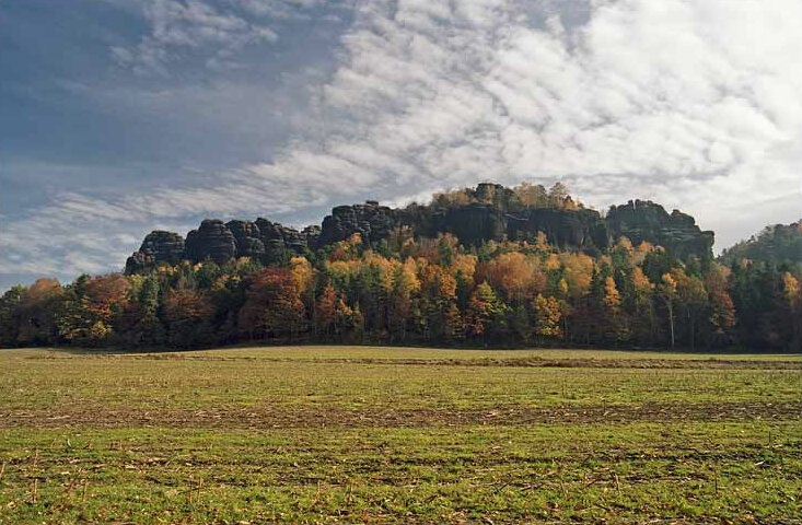
The Pfaffenstein, formerly called the Jungfernstein, is a table hill, 434.6 m (1,426 ft) above sea level, in the Elbe Sandstone Mountains in Saxony. It lies west of the River Elbe near Königstein and is also referred to as "Saxon Switzerland in miniature" on account of its diverse structure.
The wild, jagged mountain with its numerous caves reveals traces of Stone and Bronze Age settlement and was later used frequently as a place of refuge during times of crisis as a result of its poor accessibility. Since the 19th century the Pfaffenstein has been developed for touristic purposes. The hill now boasts an inn, an observation tower, several viewing points and other places of interest on the mountain.
Since the early 20th century the massif of the Pfaffenstein has been used for rock climbing and, with its 32 rocks, is one of the most important climbing areas in Saxon Switzerland. The best-known rock and symbol of the Pfaffenstein is the Barbarine, a 43-metre-high (141 ft) rock pinnacle, that has been placed out of bounds to climbers since 1975 due to serious erosion damage.
The Pfaffenstein lies about 2 kilometres (1.2 mi) south of the village of Pfaffendorf in the borough of Königstein. Another nearby settlement is Cunnersdorf about 3 kilometres (1.9 mi) southeast. Its nearest neighbour is the 349.6-metre-high (1,147 ft) Quirl to the northwest, another table hill.
To the south, the mountain is surrounded by woods that drop away to the stream of Cunnersdorfer Bach. Around the northern part of the Pfaffenstein the land is predominantly used for agriculture.
The mountain looks like an elongated summit plateau running north-to-south for about 1 kilometre (0.62 mi), with a width of up to 400 metres (1,300 ft) from west-to-east. It has an area of some twelve hectares and rises about 100 metres (330 ft) above the surrounding countryside. The actual summit lies in the southern part of the plateau. The edge of the Pfaffenstein is formed by rugged and heavily fissured sandstone rocks. There are numerous isolated rock formations around the main massif, the best-known being the Barbarine on the southern tip of the Pfaffenstein. Other significant rock pinnacles are the Königspitze, the Förster, the Bundesfels, the Rauhe Zinne, the Jäckelfels, the Pfaffenschluchtspitzen, the Peterskirche and the Einsiedler.
The name Pfaffenstein is very probably derived from the nearby village of Pfaffendorf. This settlement in the borough of Königstein was given its name because its inhabitants paid taxes to the church at Königstein in the Middle Ages, as evinced by the first mention of the village's name in the records in 1437. Its old name of Jungfernstein ("Virgin Rock") comes from a legend about the origin of the Barbarine rock pinnacle, according to which a woman sent her daughter to church on Sundays. However, when she caught her picking bilberries on the Pfaffenstein instead, the mother cursed her daughter, turning her to stone.
The plateau of the Pfaffenstein had already been settled by about 3,000 years ago. Archaeological excavations unearthed both Stone Age and Bronze Age artefacts of the Lusatian Culture. On the plateau, near the present hilltop inn, various stone flat axes, clay vessels, a grinding stone and the site of a hearth came to light during digs from 1896 to 1912. In 1921 the innkeeper, Richard Keiler, found two bronze bangles. Other excavations were carried out on the plateau in 1967; they confirmed the settlement as being part of the Lusatian Culture. The diggers found more ceramic artefacts and a whetstone.
Hub AI
Pfaffenstein AI simulator
(@Pfaffenstein_simulator)
Pfaffenstein
The Pfaffenstein, formerly called the Jungfernstein, is a table hill, 434.6 m (1,426 ft) above sea level, in the Elbe Sandstone Mountains in Saxony. It lies west of the River Elbe near Königstein and is also referred to as "Saxon Switzerland in miniature" on account of its diverse structure.
The wild, jagged mountain with its numerous caves reveals traces of Stone and Bronze Age settlement and was later used frequently as a place of refuge during times of crisis as a result of its poor accessibility. Since the 19th century the Pfaffenstein has been developed for touristic purposes. The hill now boasts an inn, an observation tower, several viewing points and other places of interest on the mountain.
Since the early 20th century the massif of the Pfaffenstein has been used for rock climbing and, with its 32 rocks, is one of the most important climbing areas in Saxon Switzerland. The best-known rock and symbol of the Pfaffenstein is the Barbarine, a 43-metre-high (141 ft) rock pinnacle, that has been placed out of bounds to climbers since 1975 due to serious erosion damage.
The Pfaffenstein lies about 2 kilometres (1.2 mi) south of the village of Pfaffendorf in the borough of Königstein. Another nearby settlement is Cunnersdorf about 3 kilometres (1.9 mi) southeast. Its nearest neighbour is the 349.6-metre-high (1,147 ft) Quirl to the northwest, another table hill.
To the south, the mountain is surrounded by woods that drop away to the stream of Cunnersdorfer Bach. Around the northern part of the Pfaffenstein the land is predominantly used for agriculture.
The mountain looks like an elongated summit plateau running north-to-south for about 1 kilometre (0.62 mi), with a width of up to 400 metres (1,300 ft) from west-to-east. It has an area of some twelve hectares and rises about 100 metres (330 ft) above the surrounding countryside. The actual summit lies in the southern part of the plateau. The edge of the Pfaffenstein is formed by rugged and heavily fissured sandstone rocks. There are numerous isolated rock formations around the main massif, the best-known being the Barbarine on the southern tip of the Pfaffenstein. Other significant rock pinnacles are the Königspitze, the Förster, the Bundesfels, the Rauhe Zinne, the Jäckelfels, the Pfaffenschluchtspitzen, the Peterskirche and the Einsiedler.
The name Pfaffenstein is very probably derived from the nearby village of Pfaffendorf. This settlement in the borough of Königstein was given its name because its inhabitants paid taxes to the church at Königstein in the Middle Ages, as evinced by the first mention of the village's name in the records in 1437. Its old name of Jungfernstein ("Virgin Rock") comes from a legend about the origin of the Barbarine rock pinnacle, according to which a woman sent her daughter to church on Sundays. However, when she caught her picking bilberries on the Pfaffenstein instead, the mother cursed her daughter, turning her to stone.
The plateau of the Pfaffenstein had already been settled by about 3,000 years ago. Archaeological excavations unearthed both Stone Age and Bronze Age artefacts of the Lusatian Culture. On the plateau, near the present hilltop inn, various stone flat axes, clay vessels, a grinding stone and the site of a hearth came to light during digs from 1896 to 1912. In 1921 the innkeeper, Richard Keiler, found two bronze bangles. Other excavations were carried out on the plateau in 1967; they confirmed the settlement as being part of the Lusatian Culture. The diggers found more ceramic artefacts and a whetstone.
Recent media