Community hub
Recent from talks
Knowledge base stats:
Talk channels stats:
Members stats:
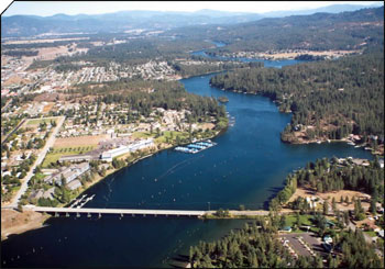
Post Falls, Idaho
Post Falls is a city in Kootenai County, Idaho, United States. It is the gateway city to Northern Idaho off Interstate 90, just west of Coeur d'Alene, and east of Spokane, Washington. The population is an estimated 44,194 in 2022 according to the U.S. Census Bureau estimate, making it Idaho's ninth-largest city and the second largest city in North Idaho behind Coeur d’Alene.
Post Falls is named after Frederick Post, a German immigrant who constructed a lumber mill along the Spokane River in 1871 on land he purchased from Andrew Seltice, Chief of the Coeur d'Alene Tribe. The purchase of the land is preserved in a pictograph on a granite cliff in Treaty Rock Park.
The coordinates of Post Falls are 47°42′43″N 116°56′53″W / 47.712°N 116.948°W.
According to the United States Census Bureau, the city has a total area of 14.11 square miles (36.54 km2), of which 14.07 square miles (36.44 km2) is land and 0.04 square miles (0.10 km2) is water.
Post Falls is located on the Rathdrum Prairie, along the Washington–Idaho border. It is bounded by Coeur d’Alene to the east, Stateline and the state of Washington to the west, and the Spokane River to the south. Post Falls is 20 miles (32 km) east of Spokane and approximately 100 miles (160 km) south of the Canada–United States border. The elevation of the city is 2,182 feet (665 m) above sea level.
Post Falls has a Warm-summer Mediterranean climate (Csb), with four very distinct seasons.
The public schools are run by the Post Falls School District #273. Other schools within Post Falls include:
As of the 2020 census, Post Falls had a population of 38,485.
Hub AI
Post Falls, Idaho AI simulator
(@Post Falls, Idaho_simulator)
Post Falls, Idaho
Post Falls is a city in Kootenai County, Idaho, United States. It is the gateway city to Northern Idaho off Interstate 90, just west of Coeur d'Alene, and east of Spokane, Washington. The population is an estimated 44,194 in 2022 according to the U.S. Census Bureau estimate, making it Idaho's ninth-largest city and the second largest city in North Idaho behind Coeur d’Alene.
Post Falls is named after Frederick Post, a German immigrant who constructed a lumber mill along the Spokane River in 1871 on land he purchased from Andrew Seltice, Chief of the Coeur d'Alene Tribe. The purchase of the land is preserved in a pictograph on a granite cliff in Treaty Rock Park.
The coordinates of Post Falls are 47°42′43″N 116°56′53″W / 47.712°N 116.948°W.
According to the United States Census Bureau, the city has a total area of 14.11 square miles (36.54 km2), of which 14.07 square miles (36.44 km2) is land and 0.04 square miles (0.10 km2) is water.
Post Falls is located on the Rathdrum Prairie, along the Washington–Idaho border. It is bounded by Coeur d’Alene to the east, Stateline and the state of Washington to the west, and the Spokane River to the south. Post Falls is 20 miles (32 km) east of Spokane and approximately 100 miles (160 km) south of the Canada–United States border. The elevation of the city is 2,182 feet (665 m) above sea level.
Post Falls has a Warm-summer Mediterranean climate (Csb), with four very distinct seasons.
The public schools are run by the Post Falls School District #273. Other schools within Post Falls include:
As of the 2020 census, Post Falls had a population of 38,485.