Recent from talks
Qinghai Lake
Knowledge base stats:
Talk channels stats:
Members stats:
Qinghai Lake
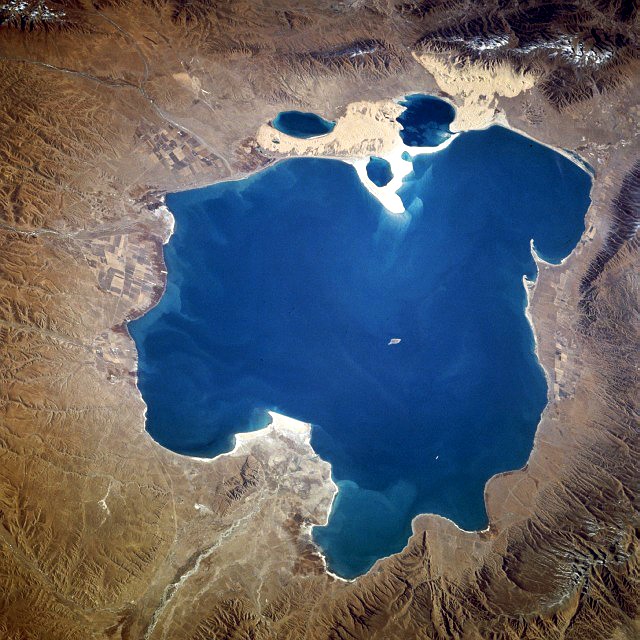
Qinghai Lake is the largest lake in China. Located in an endorheic basin in Qinghai Province, to which it gave its name, Qinghai Lake is classified as an alkaline salt lake. The lake has fluctuated in size, shrinking over much of the 20th century but increasing since 2004. It had a surface area of 4,317 km2 (1,667 sq mi), an average depth of 21 m (69 ft), and a maximum depth of 25.5 m (84 ft) in 2008.
Qinghai is the atonal pinyin romanisation of the Mandarin pronunciation of the Chinese name 青海. Although modern Chinese distinguishes between the colors blue and green, this distinction did not exist in classical Chinese. The color 青 (qīng) was a "single" color inclusive of both blue and green as separate shades. The name is thus variously translated as "Blue Sea", "Green Sea", "Blue-Green Sea", "Blue/Green Sea", etc. For a time after its wars with the Xiongnu, Han China connected the lake with the legendary "Western Sea" assumed to balance the East China Sea, but as the Han Empire expanded further west into the Tarim Basin other lakes assumed the title. The former names Chinghai, Ch'ing-hai, or Ch'inghai Lake are based on the Wade–Giles romanisation of the same Chinese name.
Qinghai Lake is also known as Koko Nor from its Classical Mongolian name ᠬᠥᠬᠡ ᠨᠠᠭᠤᠷ. The modern Mongolian form of the same name is Höhnuur (Хөхнуур). Similar to Chinese, Classical Mongolian used ᠬᠥᠬᠡ inclusive of both the color of the sky and fresh grass, but now uses xöx specifically for deep or dark blue distinguished both from light blue (цэнхэр, tsenher) and green (ногоон, nogoon). Classical Mongolian also did not distinguish between lakes and larger bodies of water. The Chinese name, using "sea" rather than "lake," is thus an overly literal calque of this name, used by the Upper Mongols, some of whom made up the local ruling class during the standardization of western Chinese toponyms in the Qing dynasty. Similar use of the Chinese word for "sea" to translate Mongolian lake toponyms can be seen elsewhere around Qinghai, as with Lake Heihai ("Black Sea") in the Kunlun Mountains. It is also the origin of one of the common names for the lake in English (Kokonor Lake).
The Tibetans also separately calqued the name as Mtsho-sngon-po or Tso ngönpo (མཚོ་སྔོན་པོ་, "Blue Lake or Sea").
Qinghai Lake lies about 100 kilometers (62 mi) west of Xining in a hollow of the Tibetan Plateau at 3,205 meters (10,515 ft) above sea level. It lies between Haibei Tibetan Autonomous Prefecture and Hainan Tibetan Autonomous Prefecture in northeastern Qinghai in Northwest China. The lake has fluctuated in size, shrinking over much of the 20th century but increasing since 2004. It had a surface area of 4,317 square kilometers (1,667 sq mi), an average depth of 21 meters (69 ft), and a maximum depth of 25.5 m (84 ft) in 2008.
Twenty-three rivers and streams empty into Qinghai Lake, most of them seasonal. Five permanent streams provide 80% of the total influx. The relatively low inflow and high evaporation rates have turned Qinghai saline and alkaline; the salt concentration is presently about 1.4% by weight (seawater has a salt concentration of about 3.5%), with a pH of 9.3. It has increased in salinity and basicity since the early Holocene.
At the tip of the peninsula on the western side of the lake are Cormorant Island and Egg Island, collectively known as the Bird Islands.
Qinghai Lake became isolated from the Yellow River about 150,000 years ago. If the water level were to rise by approximately 50 meters (160 ft), the connection to the Yellow River would be reestablished via the low pass to the east.[citation needed]
Hub AI
Qinghai Lake AI simulator
(@Qinghai Lake_simulator)
Qinghai Lake
Qinghai Lake is the largest lake in China. Located in an endorheic basin in Qinghai Province, to which it gave its name, Qinghai Lake is classified as an alkaline salt lake. The lake has fluctuated in size, shrinking over much of the 20th century but increasing since 2004. It had a surface area of 4,317 km2 (1,667 sq mi), an average depth of 21 m (69 ft), and a maximum depth of 25.5 m (84 ft) in 2008.
Qinghai is the atonal pinyin romanisation of the Mandarin pronunciation of the Chinese name 青海. Although modern Chinese distinguishes between the colors blue and green, this distinction did not exist in classical Chinese. The color 青 (qīng) was a "single" color inclusive of both blue and green as separate shades. The name is thus variously translated as "Blue Sea", "Green Sea", "Blue-Green Sea", "Blue/Green Sea", etc. For a time after its wars with the Xiongnu, Han China connected the lake with the legendary "Western Sea" assumed to balance the East China Sea, but as the Han Empire expanded further west into the Tarim Basin other lakes assumed the title. The former names Chinghai, Ch'ing-hai, or Ch'inghai Lake are based on the Wade–Giles romanisation of the same Chinese name.
Qinghai Lake is also known as Koko Nor from its Classical Mongolian name ᠬᠥᠬᠡ ᠨᠠᠭᠤᠷ. The modern Mongolian form of the same name is Höhnuur (Хөхнуур). Similar to Chinese, Classical Mongolian used ᠬᠥᠬᠡ inclusive of both the color of the sky and fresh grass, but now uses xöx specifically for deep or dark blue distinguished both from light blue (цэнхэр, tsenher) and green (ногоон, nogoon). Classical Mongolian also did not distinguish between lakes and larger bodies of water. The Chinese name, using "sea" rather than "lake," is thus an overly literal calque of this name, used by the Upper Mongols, some of whom made up the local ruling class during the standardization of western Chinese toponyms in the Qing dynasty. Similar use of the Chinese word for "sea" to translate Mongolian lake toponyms can be seen elsewhere around Qinghai, as with Lake Heihai ("Black Sea") in the Kunlun Mountains. It is also the origin of one of the common names for the lake in English (Kokonor Lake).
The Tibetans also separately calqued the name as Mtsho-sngon-po or Tso ngönpo (མཚོ་སྔོན་པོ་, "Blue Lake or Sea").
Qinghai Lake lies about 100 kilometers (62 mi) west of Xining in a hollow of the Tibetan Plateau at 3,205 meters (10,515 ft) above sea level. It lies between Haibei Tibetan Autonomous Prefecture and Hainan Tibetan Autonomous Prefecture in northeastern Qinghai in Northwest China. The lake has fluctuated in size, shrinking over much of the 20th century but increasing since 2004. It had a surface area of 4,317 square kilometers (1,667 sq mi), an average depth of 21 meters (69 ft), and a maximum depth of 25.5 m (84 ft) in 2008.
Twenty-three rivers and streams empty into Qinghai Lake, most of them seasonal. Five permanent streams provide 80% of the total influx. The relatively low inflow and high evaporation rates have turned Qinghai saline and alkaline; the salt concentration is presently about 1.4% by weight (seawater has a salt concentration of about 3.5%), with a pH of 9.3. It has increased in salinity and basicity since the early Holocene.
At the tip of the peninsula on the western side of the lake are Cormorant Island and Egg Island, collectively known as the Bird Islands.
Qinghai Lake became isolated from the Yellow River about 150,000 years ago. If the water level were to rise by approximately 50 meters (160 ft), the connection to the Yellow River would be reestablished via the low pass to the east.[citation needed]
Recent media