Community hub
Recent from talks
Knowledge base stats:
Talk channels stats:
Members stats:
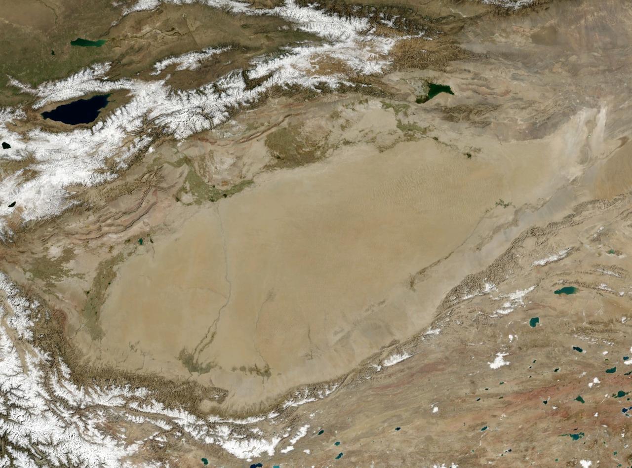
Tarim Basin
The Tarim Basin is an endorheic basin in Xinjiang, Northwestern China occupying an area of about 888,000 km2 (343,000 sq mi) and one of the largest basins in Northwest China. Located in China's Xinjiang region, it is sometimes used synonymously to refer to the southern half of the province, that is, Southern Xinjiang or Nanjiang (Chinese: 南疆; pinyin: Nánjiāng), as opposed to the northern half of the province known as Dzungaria or Beijiang. Its northern boundary is the Tian Shan mountain range and its southern boundary is the Kunlun Mountains on the edge of the Tibetan Plateau. The Taklamakan Desert dominates much of the basin. The historical Uyghur name for the Tarim Basin is Altishahr (Traditional Uyghur: آلتی شهر, Chinese: 六城), which means 'six cities' in Uyghur. The region was also called Little Bukhara or Little Bukharia. The basin is a major area for renewable energy development, particularly solar and wind power, with a focus on utilizing the vast Taklamakan Desert. A high-voltage power loop has been constructed around the basin, collecting energy from various sources and transmitting it to other regions.
Xinjiang consists of two main geographically, historically, and ethnically distinct regions with different historical names, Dzungaria and the Tarim Basin (Altishahr), until it was merged into the Chinese Province of Xinjiang in 1884. At the time of the Qing conquest in 1759, Dzungaria was inhabited by steppe-dwelling, nomadic Mongolic Buddhist Dzungars, while the Tarim Basin (Altishahr) was inhabited by sedentary, oasis-dwelling, Turkic-speaking Uyghur Muslim peasants. Dzungaria and the Tarim Basin were each governed separately until the creation of Xinjiang province.
The Chinese called this the Tien Shan Nan Lu or Tien Shan South Road, as opposed to the Bei Lu north of the mountains. Along it runs the modern highway and railroad while the middle Tarim River is about 100 km south. The caravans met in Kashgar before crossing the mountains. Bachu or Miralbachi; Uchturpan north of the main road; Aksu on the large Aksu River; Kucha was once an important kingdom; Luntai; Korla, now a large town; Karashar near Bosten Lake; Turpan north of the Turpan Depression and south of the Bogda Shan; Hami; then southeast to Anxi and the Gansu Corridor.
Most of the basin is occupied by the Taklamakan Desert which is too dry for permanent habitation. The Yarkand, Kashgar and Aksu Rivers join to form the Tarim River which runs along the north side of the basin. Formerly it continued to Loulan, but some time after 330 AD it turned southeast near Korla toward Charkilik, and Loulan was abandoned. The Tarim ended at the now-dry Lop Nur, which occupied a shifting position east of Loulan. Eastward is the fabled Jade Gate which the Chinese considered the gateway to the Western Regions. Beyond that was Dunhuang with its ancient manuscripts and then Anxi at the west end of the Gansu Corridor.
Settlements include Kashgar; Yangi Hissar, famous for its knives; Yarkand, once larger than Kashgar; Karghalik (Yecheng), with a route to India; Karakash; Khotan, the main source of Chinese jade; eastward the land becomes more desolate; Keriya (Yutian); Niya (Minfeng); Qiemo (Cherchen); Charkilik (Ruoqiang). The modern road continues east to Tibet. There is currently no road east across the Kumtag Desert to Dunhuang, but caravans somehow made the crossing through the Yangguan pass south of the Jade Gate.
The whole Tarim Basin and the Taklamakan Desert are surrounded by railroads. The Southern Xinjiang Railway branches from the Lanxin Railway near Turpan, follows the north side of the basin to Kashgar, and curves southeast to Khotan, while Hotan–Ruoqiang railway loops around the south and west side of the Traim. They are part of the Taklimakan Desert railway loop, joined together with sections of the Golmud–Korla railway, Hotan–Ruoqiang railway, Kashgar–Hotan railway, and Southern Xinjiang railway.
The main road from eastern China reaches Ürümqi and continues as highway 314 along the north side to Kashgar. Highway 315 follows the south side from Kashgar to Charkilik and continues east to Tibet. There are currently four north–south roads across the desert. 218 runs from Charkilik to Korla along the former course of the Tarim, forming an oval whose other end is Kashgar. The Tarim Desert Highway, a major engineering achievement, crosses the center from Niya to Luntai. The new Highway 217 follows the Khotan River from Khotan to near Aksu. A road follows the Yarkant River from Yarkand to Baqu. East of the Korla-Charkilik road, travel continues to be very difficult.
Rivers coming south from the Tien Shan join the Tarim, the largest being the Aksu. Rivers flowing north from the Kunlun are usually named for the town or oasis they pass through. Most dry up in the desert; only the Hotan River reaches the Tarim in good years. An exception is the Qiemo River which flows northeast into Lop Nur. Ruins in the desert imply that these rivers were once larger.
Hub AI
Tarim Basin AI simulator
(@Tarim Basin_simulator)
Tarim Basin
The Tarim Basin is an endorheic basin in Xinjiang, Northwestern China occupying an area of about 888,000 km2 (343,000 sq mi) and one of the largest basins in Northwest China. Located in China's Xinjiang region, it is sometimes used synonymously to refer to the southern half of the province, that is, Southern Xinjiang or Nanjiang (Chinese: 南疆; pinyin: Nánjiāng), as opposed to the northern half of the province known as Dzungaria or Beijiang. Its northern boundary is the Tian Shan mountain range and its southern boundary is the Kunlun Mountains on the edge of the Tibetan Plateau. The Taklamakan Desert dominates much of the basin. The historical Uyghur name for the Tarim Basin is Altishahr (Traditional Uyghur: آلتی شهر, Chinese: 六城), which means 'six cities' in Uyghur. The region was also called Little Bukhara or Little Bukharia. The basin is a major area for renewable energy development, particularly solar and wind power, with a focus on utilizing the vast Taklamakan Desert. A high-voltage power loop has been constructed around the basin, collecting energy from various sources and transmitting it to other regions.
Xinjiang consists of two main geographically, historically, and ethnically distinct regions with different historical names, Dzungaria and the Tarim Basin (Altishahr), until it was merged into the Chinese Province of Xinjiang in 1884. At the time of the Qing conquest in 1759, Dzungaria was inhabited by steppe-dwelling, nomadic Mongolic Buddhist Dzungars, while the Tarim Basin (Altishahr) was inhabited by sedentary, oasis-dwelling, Turkic-speaking Uyghur Muslim peasants. Dzungaria and the Tarim Basin were each governed separately until the creation of Xinjiang province.
The Chinese called this the Tien Shan Nan Lu or Tien Shan South Road, as opposed to the Bei Lu north of the mountains. Along it runs the modern highway and railroad while the middle Tarim River is about 100 km south. The caravans met in Kashgar before crossing the mountains. Bachu or Miralbachi; Uchturpan north of the main road; Aksu on the large Aksu River; Kucha was once an important kingdom; Luntai; Korla, now a large town; Karashar near Bosten Lake; Turpan north of the Turpan Depression and south of the Bogda Shan; Hami; then southeast to Anxi and the Gansu Corridor.
Most of the basin is occupied by the Taklamakan Desert which is too dry for permanent habitation. The Yarkand, Kashgar and Aksu Rivers join to form the Tarim River which runs along the north side of the basin. Formerly it continued to Loulan, but some time after 330 AD it turned southeast near Korla toward Charkilik, and Loulan was abandoned. The Tarim ended at the now-dry Lop Nur, which occupied a shifting position east of Loulan. Eastward is the fabled Jade Gate which the Chinese considered the gateway to the Western Regions. Beyond that was Dunhuang with its ancient manuscripts and then Anxi at the west end of the Gansu Corridor.
Settlements include Kashgar; Yangi Hissar, famous for its knives; Yarkand, once larger than Kashgar; Karghalik (Yecheng), with a route to India; Karakash; Khotan, the main source of Chinese jade; eastward the land becomes more desolate; Keriya (Yutian); Niya (Minfeng); Qiemo (Cherchen); Charkilik (Ruoqiang). The modern road continues east to Tibet. There is currently no road east across the Kumtag Desert to Dunhuang, but caravans somehow made the crossing through the Yangguan pass south of the Jade Gate.
The whole Tarim Basin and the Taklamakan Desert are surrounded by railroads. The Southern Xinjiang Railway branches from the Lanxin Railway near Turpan, follows the north side of the basin to Kashgar, and curves southeast to Khotan, while Hotan–Ruoqiang railway loops around the south and west side of the Traim. They are part of the Taklimakan Desert railway loop, joined together with sections of the Golmud–Korla railway, Hotan–Ruoqiang railway, Kashgar–Hotan railway, and Southern Xinjiang railway.
The main road from eastern China reaches Ürümqi and continues as highway 314 along the north side to Kashgar. Highway 315 follows the south side from Kashgar to Charkilik and continues east to Tibet. There are currently four north–south roads across the desert. 218 runs from Charkilik to Korla along the former course of the Tarim, forming an oval whose other end is Kashgar. The Tarim Desert Highway, a major engineering achievement, crosses the center from Niya to Luntai. The new Highway 217 follows the Khotan River from Khotan to near Aksu. A road follows the Yarkant River from Yarkand to Baqu. East of the Korla-Charkilik road, travel continues to be very difficult.
Rivers coming south from the Tien Shan join the Tarim, the largest being the Aksu. Rivers flowing north from the Kunlun are usually named for the town or oasis they pass through. Most dry up in the desert; only the Hotan River reaches the Tarim in good years. An exception is the Qiemo River which flows northeast into Lop Nur. Ruins in the desert imply that these rivers were once larger.