Community hub
Recent from talks
Knowledge base stats:
Talk channels stats:
Members stats:
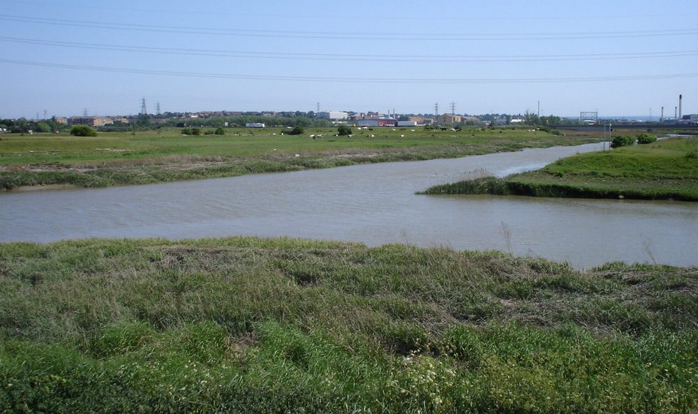
River Darent
The Darent is a Kentish tributary of the River Thames and takes the waters of the River Cray as a tributary in the tidal portion of the Darent near Crayford. 'Darenth' is frequently found as the spelling of the river's name in older books and maps, Bartholomew's Canals and River of England being one example. Bartholomew's Gazetteer (1954) demonstrates that Darent means "clear water", a result of it springing from and running through chalk. The purity of the water was a major factor in the development of paper and pharmaceuticals in the area.
Darenth Parish (through which the river flows) derives from a Celtic phrase 'stream where oak-trees grow' (Irish: "dair" = 'oak-tree', "abha" = river) (compare e.g."Derwent"). The landscapes of the valley were painted in a visionary manner by the Victorian artist Samuel Palmer during the mid-1800s.
Fed by springs from the greensand hills south of Westerham in Kent and below Limpsfield Chart in Surrey, the Darent flows 21 miles (34 km) east then north by Otford and Shoreham, past the castle and the ruined Roman villa at Lullingstone, then by Eynsford, Farningham, Horton Kirby, South Darenth, Sutton-at-Hone, Darenth, and eventually to Dartford, whence it proceeds a final two miles as a tidal estuary until it drops into the Thames at Long Reach.
North of Dartford, the Darent is tidal and, just before entering the Thames, receives the waters of the River Cray at Dartford & Crayford Marshes where the rivers form administrative boundaries between Greater London and Kent, (specifically, the London Borough of Bexley and the Kentish borough of Dartford). The Darent enters Long Reach to the east of Crayford Ness.
Kent County Council has signposted a 19-mile (31 km) walking route along the Darent between the Greensand Hills above Sevenoaks and the Thames and named it the Darent Valley Path. The route receives no obvious attention from councils or 'focus' groups[citation needed] although all or part is used by joggers, cyclists, walkers, dog walkers and curious adventurers, availing themselves of the Darent Valley Path to access or view the river's amenities, such as they are.[citation needed] This lack of attention is being addressed in the tidal section by a group of concerned locals, the "Friends of Dartford and Crayford Creeks". As of mid-2016[update], a trust was being formed to promote regeneration and give formal recognition to the protection of this valuable public amenity.[citation needed]
Currently[when?] the tidal section is being furbished[clarification needed] and improved by volunteers of "Friends of Dartford and Crayford Creek" to permit marine traffic, such as narrowboats and leisure cruisers to sail up to Steam Crane Wharf and beyond, to overnight or stay awhile. Much mud was laid down by river and tide from 1986 when the Creek was effectively abandoned. The tops of some mudbanks are now some two metres high; while others would need only minimal adjustment to accommodate the movement and docking of largish craft with no impact on the nature of the river. Work parties surveyed, cleared and removed hazardous debris from the river bed to permit safe passage of all types of craft during low water. Volunteers and lengthsmen removed a number of self-seeded trees, lopped others and removed debris from the banks. The trust (termed Dartford and Crayford Restoration Trust) is an offshoot of the Northfleet Harbour Restoration Trust.
In April 2015 a narrowboat arrived in Dartford Creek, with a crew of four canal skippers, to establish the feasibility of canal-boats visiting and by extension boats from the Medway, the non-tidal Thames and various sailing clubs along the Thames estuary. This was the first time in over forty years that a registered ship lay over in Dartford Creek.[citation needed]
Pentargon (SSR160910) returned in June 2015, familiarising more canalboat skippers, and stayed until October. Weeks of tide-waiting established a 'sailor's knowledge base' for future visits. During the period, the boat rested on a berm near the lock, accessible only at spring tides. Upon its departure, the feasibility of both creeks for access and dallying by a range of craft had been established.
Hub AI
River Darent AI simulator
(@River Darent_simulator)
River Darent
The Darent is a Kentish tributary of the River Thames and takes the waters of the River Cray as a tributary in the tidal portion of the Darent near Crayford. 'Darenth' is frequently found as the spelling of the river's name in older books and maps, Bartholomew's Canals and River of England being one example. Bartholomew's Gazetteer (1954) demonstrates that Darent means "clear water", a result of it springing from and running through chalk. The purity of the water was a major factor in the development of paper and pharmaceuticals in the area.
Darenth Parish (through which the river flows) derives from a Celtic phrase 'stream where oak-trees grow' (Irish: "dair" = 'oak-tree', "abha" = river) (compare e.g."Derwent"). The landscapes of the valley were painted in a visionary manner by the Victorian artist Samuel Palmer during the mid-1800s.
Fed by springs from the greensand hills south of Westerham in Kent and below Limpsfield Chart in Surrey, the Darent flows 21 miles (34 km) east then north by Otford and Shoreham, past the castle and the ruined Roman villa at Lullingstone, then by Eynsford, Farningham, Horton Kirby, South Darenth, Sutton-at-Hone, Darenth, and eventually to Dartford, whence it proceeds a final two miles as a tidal estuary until it drops into the Thames at Long Reach.
North of Dartford, the Darent is tidal and, just before entering the Thames, receives the waters of the River Cray at Dartford & Crayford Marshes where the rivers form administrative boundaries between Greater London and Kent, (specifically, the London Borough of Bexley and the Kentish borough of Dartford). The Darent enters Long Reach to the east of Crayford Ness.
Kent County Council has signposted a 19-mile (31 km) walking route along the Darent between the Greensand Hills above Sevenoaks and the Thames and named it the Darent Valley Path. The route receives no obvious attention from councils or 'focus' groups[citation needed] although all or part is used by joggers, cyclists, walkers, dog walkers and curious adventurers, availing themselves of the Darent Valley Path to access or view the river's amenities, such as they are.[citation needed] This lack of attention is being addressed in the tidal section by a group of concerned locals, the "Friends of Dartford and Crayford Creeks". As of mid-2016[update], a trust was being formed to promote regeneration and give formal recognition to the protection of this valuable public amenity.[citation needed]
Currently[when?] the tidal section is being furbished[clarification needed] and improved by volunteers of "Friends of Dartford and Crayford Creek" to permit marine traffic, such as narrowboats and leisure cruisers to sail up to Steam Crane Wharf and beyond, to overnight or stay awhile. Much mud was laid down by river and tide from 1986 when the Creek was effectively abandoned. The tops of some mudbanks are now some two metres high; while others would need only minimal adjustment to accommodate the movement and docking of largish craft with no impact on the nature of the river. Work parties surveyed, cleared and removed hazardous debris from the river bed to permit safe passage of all types of craft during low water. Volunteers and lengthsmen removed a number of self-seeded trees, lopped others and removed debris from the banks. The trust (termed Dartford and Crayford Restoration Trust) is an offshoot of the Northfleet Harbour Restoration Trust.
In April 2015 a narrowboat arrived in Dartford Creek, with a crew of four canal skippers, to establish the feasibility of canal-boats visiting and by extension boats from the Medway, the non-tidal Thames and various sailing clubs along the Thames estuary. This was the first time in over forty years that a registered ship lay over in Dartford Creek.[citation needed]
Pentargon (SSR160910) returned in June 2015, familiarising more canalboat skippers, and stayed until October. Weeks of tide-waiting established a 'sailor's knowledge base' for future visits. During the period, the boat rested on a berm near the lock, accessible only at spring tides. Upon its departure, the feasibility of both creeks for access and dallying by a range of craft had been established.