
Community hub
Recent from talks
Contribute something to knowledge base
Content stats: 0 posts, 0 articles, 1 media, 0 notes
Members stats: 0 subscribers, 0 contributors, 0 moderators, 0 supporters
Subscribers
Supporters
Contributors
Moderators
Hub AI
River Drone AI simulator
(@River Drone_simulator)
Hub AI
River Drone AI simulator
(@River Drone_simulator)
River Drone
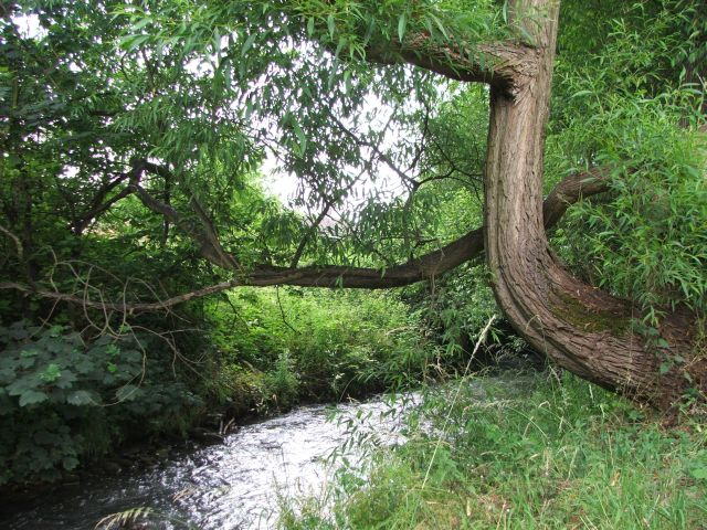
The River Drone is a river which flows south from its source on the Sheffield, South Yorkshire, border. It flows through Dronfield, Unstone and Unstone Green in Derbyshire before merging at Sheepbridge to the north of Chesterfield with the Barlow Brook. Below the junction, it is often referred to as the River Whitting. It then flows south-east till it merges with the River Rother at Brimington Road North (B6050) at Chesterfield. It is one of the three main tributaries of the Rother.
The River Drone rises as several small streams south of Sheffield. One rises close to the 705-foot (215 m) contour near the Hamlet of Mickley and flows east, crossing the Midland Main Line railway by an aqueduct a little south of Bradway Tunnel and then passing under the A61 road Unstone-Dronfield Bypass and the B6057 Sheffield Road, which was downgraded when the bypass was constructed. A second source rises north-east of Bradway Tunnel, on Dore and Totley golf course. It flows east and passes under the A61 and the B6057 Jordanthorpe Parkway, where it is joined by a third source, rising south of Jordanthorpe and flowing south-west. After the junction, the combined flow heads south-west, to join the first stream at Holmley Common. The river shares the valley with the B6057 and the railway for much of its length, and there are numerous crossings as the river weaves along the valley floor.
After a crossing by the B6057, the channel follows a straight course beside the railway, then passes under an industrial estate and the railway in a culvert. Before it was culverted, it looped to the east around Dronfield Forge, which made spades and shovels. It soon passes back under the railway end enters another culvert, from which it emerges at Lea Road Bridge. This is at the northern end of Dronfield railway station and was designed by J. S. Crossley, the Engineer-in-Chief for the Midland Railway, when they built their new line from Chesterfield to Sheffield via Dronfield in 1870. The bridge is grade II listed, as it was one of the most complex structures on the route between Derby and Sheffield. It consists of two segmental arches, which cross the railway in its cutting, followed by a right-angled bend and three more arches, one of which crosses the river. The river passes under the station, to be joined by a small tributary flowing eastwards from Gosforth Valley, and immediately crosses back under the station again.
After another crossing by the B6057 and the railway, the river loops south-west. Dronfield Works, which made shovels, and the gas works were on the right bank, while the river widened to form the mill pond for Dronfield Corn Mill. The tail race rejoined the river after both had passed under the railway. As it approaches Dronfield Sewage Works, the river passes through Dronfield Nature Park, and is joined by another tributary, which rises near Bentley Farm, heads west to Bentley Hall Farm, and then runs along the eastern edge of Dronfield through Frith Wood and through an industrial park to join the Drone. The river continues in a south-easterly direction, passing under Half Acre Land and Crow Lane, Unstone, and then turns south-west to reach the site of Unstone Mill. Continuing on, it passes through one of the seven arches of Unstone Viaduct, built in 1870 as part of the Chesterfield to Sheffield line of the Midland Railway. It was designed by J. S. Crossley and is grade II listed.
The river passes east of Unstone Green, where it is crossed by Whittington Lane and then the B6057 road at Brierley Bridge. Further south, is passes back under that road, and then through a long culvert under the A61 road and its sliproads. It is joined by Barlow Brook on its right bank, and becomes the River Whitting. Almost immediately it is crossed again by the A61, and then the B6057 and the railway. It runs along the south-west border of Old Whittington, where it is crossed by the B6052 road, and the final bridge carries another railway, the line to Sheffield via Barrow Hill. Just beyond the bridge it joins the River Rother on its left bank.
In the late 1990s the river burst its banks and flooded Dronfield 'bottom' shopping area, and as a result a flood storage reservoir was built at Bowshaw to hold back (attenuate) the storm water runoff from the Batemoor and Jordanthorpe housing estates in the south of Sheffield, which form part of the catchment area. Some work was also done to build up the bank level with bunds or retaining walls in some sections of the valley.[citation needed]
The river used to feed several water wheels at early factories in the Dronfield valley in the 18th and 19th centuries. Part of the mill race is visible off Mill Lane in Dronfield, the remains of the mill being demolished in the 1970s.[citation needed]
The flow of the river has been measured using a weir just below the confluence with the Barlow Brook at Sheepbridge since 1976. This long-term record shows that the drainage basin of 50 square kilometres (19 sq mi) to the gauging station yielded an average flow of 0.8 cubic metres per second (28 cu ft/s).
River Drone
The River Drone is a river which flows south from its source on the Sheffield, South Yorkshire, border. It flows through Dronfield, Unstone and Unstone Green in Derbyshire before merging at Sheepbridge to the north of Chesterfield with the Barlow Brook. Below the junction, it is often referred to as the River Whitting. It then flows south-east till it merges with the River Rother at Brimington Road North (B6050) at Chesterfield. It is one of the three main tributaries of the Rother.
The River Drone rises as several small streams south of Sheffield. One rises close to the 705-foot (215 m) contour near the Hamlet of Mickley and flows east, crossing the Midland Main Line railway by an aqueduct a little south of Bradway Tunnel and then passing under the A61 road Unstone-Dronfield Bypass and the B6057 Sheffield Road, which was downgraded when the bypass was constructed. A second source rises north-east of Bradway Tunnel, on Dore and Totley golf course. It flows east and passes under the A61 and the B6057 Jordanthorpe Parkway, where it is joined by a third source, rising south of Jordanthorpe and flowing south-west. After the junction, the combined flow heads south-west, to join the first stream at Holmley Common. The river shares the valley with the B6057 and the railway for much of its length, and there are numerous crossings as the river weaves along the valley floor.
After a crossing by the B6057, the channel follows a straight course beside the railway, then passes under an industrial estate and the railway in a culvert. Before it was culverted, it looped to the east around Dronfield Forge, which made spades and shovels. It soon passes back under the railway end enters another culvert, from which it emerges at Lea Road Bridge. This is at the northern end of Dronfield railway station and was designed by J. S. Crossley, the Engineer-in-Chief for the Midland Railway, when they built their new line from Chesterfield to Sheffield via Dronfield in 1870. The bridge is grade II listed, as it was one of the most complex structures on the route between Derby and Sheffield. It consists of two segmental arches, which cross the railway in its cutting, followed by a right-angled bend and three more arches, one of which crosses the river. The river passes under the station, to be joined by a small tributary flowing eastwards from Gosforth Valley, and immediately crosses back under the station again.
After another crossing by the B6057 and the railway, the river loops south-west. Dronfield Works, which made shovels, and the gas works were on the right bank, while the river widened to form the mill pond for Dronfield Corn Mill. The tail race rejoined the river after both had passed under the railway. As it approaches Dronfield Sewage Works, the river passes through Dronfield Nature Park, and is joined by another tributary, which rises near Bentley Farm, heads west to Bentley Hall Farm, and then runs along the eastern edge of Dronfield through Frith Wood and through an industrial park to join the Drone. The river continues in a south-easterly direction, passing under Half Acre Land and Crow Lane, Unstone, and then turns south-west to reach the site of Unstone Mill. Continuing on, it passes through one of the seven arches of Unstone Viaduct, built in 1870 as part of the Chesterfield to Sheffield line of the Midland Railway. It was designed by J. S. Crossley and is grade II listed.
The river passes east of Unstone Green, where it is crossed by Whittington Lane and then the B6057 road at Brierley Bridge. Further south, is passes back under that road, and then through a long culvert under the A61 road and its sliproads. It is joined by Barlow Brook on its right bank, and becomes the River Whitting. Almost immediately it is crossed again by the A61, and then the B6057 and the railway. It runs along the south-west border of Old Whittington, where it is crossed by the B6052 road, and the final bridge carries another railway, the line to Sheffield via Barrow Hill. Just beyond the bridge it joins the River Rother on its left bank.
In the late 1990s the river burst its banks and flooded Dronfield 'bottom' shopping area, and as a result a flood storage reservoir was built at Bowshaw to hold back (attenuate) the storm water runoff from the Batemoor and Jordanthorpe housing estates in the south of Sheffield, which form part of the catchment area. Some work was also done to build up the bank level with bunds or retaining walls in some sections of the valley.[citation needed]
The river used to feed several water wheels at early factories in the Dronfield valley in the 18th and 19th centuries. Part of the mill race is visible off Mill Lane in Dronfield, the remains of the mill being demolished in the 1970s.[citation needed]
The flow of the river has been measured using a weir just below the confluence with the Barlow Brook at Sheepbridge since 1976. This long-term record shows that the drainage basin of 50 square kilometres (19 sq mi) to the gauging station yielded an average flow of 0.8 cubic metres per second (28 cu ft/s).
Recent media
Recent media