Recent from talks
River Wye
Knowledge base stats:
Talk channels stats:
Members stats:
River Wye
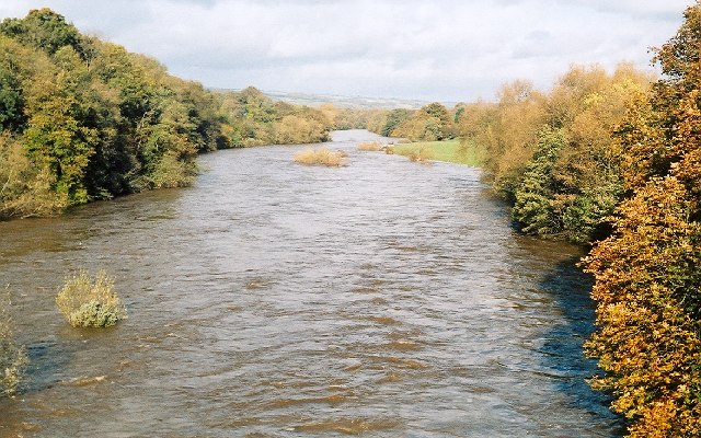
The River Wye (/waɪ/; Welsh: Afon Gwy [ɡʊɨ̯]) is the fourth-longest river in the UK, stretching some 250 kilometres (155 miles) from its source on Plynlimon in Mid Wales to the Severn Estuary. The lower reaches of the river form part of the border between England and Wales. The Wye Valley (lower part) is designated a National Landscape (formerly an Area of Outstanding Natural Beauty). The Wye is important for nature conservation and recreation, but is affected by pollution.
The meaning of the river's name is not clear. Possibly the earliest reference to the name is Guoy in Nennius' early 9th Century Historia Brittonum and the modern Welsh name is Gwy, meaning wet or liquid. The Wye was much later given a Latin name, Vaga, an adjective meaning 'wandering'. The Tithe map references a Vagas Field in both Whitchurch and Chepstow. Philologists such as Edward Lye and Joseph Bosworth in the 18th and early 19th centuries suggested an Old English derivation from wæġ, 'wave'.
The source of the Wye is in the Welsh mountains at Plynlimon. It flows through or past several towns and villages, including Rhayader, Builth Wells, Hay-on-Wye, Hereford (the only city on the River Wye), Ross-on-Wye, Symonds Yat, Monmouth and Tintern, meeting the Severn estuary just below Chepstow. The lower 16 miles (26 km) of the river from Redbrook to Chepstow form the border between England and Wales.
The River Wye is protected by two Sites of Special Scientific Interest, one covering the Upper Wye (Gwy Uchaf) above Hay-on-Wye, and one covering the Lower Wye (Gwy Isaf) downstream to Chepstow. The criteria for inclusion of the river as an SSSI include geology, topography, flora, mammals, invertebrates, fish and birdlife, as the river and its tributaries constitute a large linear ecosystem. The Lower Wye SSSI is itself divided into seven units of assessment set by Natural England, and administrative responsibilities are shared between the councils of Powys, Herefordshire, Gloucestershire, and Monmouthshire. The Wye abuts a range of other SSSIs in England and Wales, including the Upper Wye Gorge and Lower Wye Gorge.
It is also a Special Area of Conservation and one of the most important rivers in the UK for nature conservation. It is an important migration route and wildlife corridor, as well as a key breeding area for many nationally and internationally important species. The river supports a range of species and habitats covered by European Directives and those listed under Schedule 5 of the Wildlife and Countryside Act 1981. In Powys the river lies within the Radnorshire Environmentally Sensitive Area. Much of the lower valley is an Area of Outstanding Natural Beauty.
The Lower Wye has been designated as a salmonid fishery under the EC Freshwater Fish Directive.
The Wye was particularly famous for its large "spring" salmon that had spent three or more years at sea before returning to spawn. They used to enter the river between January and June and sometimes reached weights of over 50 pounds (23 kg), the largest recorded being 59 lb 8 oz (27.0 kg) landed after a long fight by Miss Doreen Davey from the Cowpond Pool at Winforton on 13 March 1923. The last recorded 50 lb (23 kg) rod-caught salmon from the Wye was taken in 1963 by Donald Parrish and weighed 51 lb 8 oz (23.4 kg). Since the early 2000s the spring catch has been steadily recovering and salmon of over 35 lb (16 kg) have been reported every year since 2011.
Pollution has severely affected the river; the Wye does not meet European and national standards on river health. This has been happening for some time; a Nutrient Management Board (NMB) was established in 2014 to address the issues. Pollution from chicken and dairy farms has become so bad the Wye has been used as an example of river pollution in the UK on Countryfile and in several national newspapers.
Hub AI
River Wye AI simulator
(@River Wye_simulator)
River Wye
The River Wye (/waɪ/; Welsh: Afon Gwy [ɡʊɨ̯]) is the fourth-longest river in the UK, stretching some 250 kilometres (155 miles) from its source on Plynlimon in Mid Wales to the Severn Estuary. The lower reaches of the river form part of the border between England and Wales. The Wye Valley (lower part) is designated a National Landscape (formerly an Area of Outstanding Natural Beauty). The Wye is important for nature conservation and recreation, but is affected by pollution.
The meaning of the river's name is not clear. Possibly the earliest reference to the name is Guoy in Nennius' early 9th Century Historia Brittonum and the modern Welsh name is Gwy, meaning wet or liquid. The Wye was much later given a Latin name, Vaga, an adjective meaning 'wandering'. The Tithe map references a Vagas Field in both Whitchurch and Chepstow. Philologists such as Edward Lye and Joseph Bosworth in the 18th and early 19th centuries suggested an Old English derivation from wæġ, 'wave'.
The source of the Wye is in the Welsh mountains at Plynlimon. It flows through or past several towns and villages, including Rhayader, Builth Wells, Hay-on-Wye, Hereford (the only city on the River Wye), Ross-on-Wye, Symonds Yat, Monmouth and Tintern, meeting the Severn estuary just below Chepstow. The lower 16 miles (26 km) of the river from Redbrook to Chepstow form the border between England and Wales.
The River Wye is protected by two Sites of Special Scientific Interest, one covering the Upper Wye (Gwy Uchaf) above Hay-on-Wye, and one covering the Lower Wye (Gwy Isaf) downstream to Chepstow. The criteria for inclusion of the river as an SSSI include geology, topography, flora, mammals, invertebrates, fish and birdlife, as the river and its tributaries constitute a large linear ecosystem. The Lower Wye SSSI is itself divided into seven units of assessment set by Natural England, and administrative responsibilities are shared between the councils of Powys, Herefordshire, Gloucestershire, and Monmouthshire. The Wye abuts a range of other SSSIs in England and Wales, including the Upper Wye Gorge and Lower Wye Gorge.
It is also a Special Area of Conservation and one of the most important rivers in the UK for nature conservation. It is an important migration route and wildlife corridor, as well as a key breeding area for many nationally and internationally important species. The river supports a range of species and habitats covered by European Directives and those listed under Schedule 5 of the Wildlife and Countryside Act 1981. In Powys the river lies within the Radnorshire Environmentally Sensitive Area. Much of the lower valley is an Area of Outstanding Natural Beauty.
The Lower Wye has been designated as a salmonid fishery under the EC Freshwater Fish Directive.
The Wye was particularly famous for its large "spring" salmon that had spent three or more years at sea before returning to spawn. They used to enter the river between January and June and sometimes reached weights of over 50 pounds (23 kg), the largest recorded being 59 lb 8 oz (27.0 kg) landed after a long fight by Miss Doreen Davey from the Cowpond Pool at Winforton on 13 March 1923. The last recorded 50 lb (23 kg) rod-caught salmon from the Wye was taken in 1963 by Donald Parrish and weighed 51 lb 8 oz (23.4 kg). Since the early 2000s the spring catch has been steadily recovering and salmon of over 35 lb (16 kg) have been reported every year since 2011.
Pollution has severely affected the river; the Wye does not meet European and national standards on river health. This has been happening for some time; a Nutrient Management Board (NMB) was established in 2014 to address the issues. Pollution from chicken and dairy farms has become so bad the Wye has been used as an example of river pollution in the UK on Countryfile and in several national newspapers.
Recent media