21°58′09″S 46°47′53″W / 21.96917°S 46.79806°W
You can help expand this article with text translated from the corresponding article in Portuguese. Click [show] for important translation instructions.
|
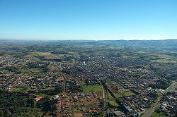
São João da Boa Vista (Portuguese pronunciation: [ˈsɐ̃w ʒuˈɐ̃w dɐ ˈboɐ ˈvistɐ]; "Saint John of the Good View" in English) is a municipality in the state of São Paulo, Brazil. The population in 2020 was 91,771 and the area is 516.399 square kilometres (199.383 sq mi). The elevation is 767 metres (2,516 ft).[3]
The city was founded on June 24, 1824, when a group of miners decided to rest at the edge of Jaguari Mirim River, which was already in the state of São Paulo. Amazed by the beauty of the natural surroundings, the miners decided immediately to establish a town on the site and, to celebrate that day's saint as well as the amazing views at sunset, the city was named São João da Boa Vista. Only 14 years later, the town was declared a district. On March 24, 1859 it became a city, and on February 7, 1885 it became a judicial district, providing to its citizens all of the basic infrastructure.
According to IBGE 2010, São João da Boa Vista has 83,661 inhabitants.
| Color/Race | Percentage |
|---|---|
| White | 85,36% |
| African | 4,47% |
| Multiracial | 9,54% |
| Asian | 0,09% |
| Indigenous Peoples | 0,03% |
| Without Declaration | 0,50% |
In telecommunications, the city was served by Telecomunicações de São Paulo.[4] In July 1998, this company was acquired by Telefónica, which adopted the Vivo brand in 2012. The company is currently an operator of cell phones, fixed lines, internet (fiber optics/4G) and television (satellite and cable).[5]
| Climate data for São João da Boa Vista, elevation 776 m (2,546 ft), (2006–2020 normals, extremes 2005–2014) | |||||||||||||
|---|---|---|---|---|---|---|---|---|---|---|---|---|---|
| Month | Jan | Feb | Mar | Apr | May | Jun | Jul | Aug | Sep | Oct | Nov | Dec | Year |
| Record high °C (°F) | 34.7 (94.5) |
35.1 (95.2) |
35.6 (96.1) |
34.8 (94.6) |
32.0 (89.6) |
31.8 (89.2) |
33.4 (92.1) |
35.0 (95.0) |
37.0 (98.6) |
40.6 (105.1) |
36.2 (97.2) |
37.3 (99.1) |
40.6 (105.1) |
| Mean daily maximum °C (°F) | 29.6 (85.3) |
30.3 (86.5) |
29.6 (85.3) |
28.5 (83.3) |
25.9 (78.6) |
25.0 (77.0) |
25.6 (78.1) |
27.5 (81.5) |
29.3 (84.7) |
30.1 (86.2) |
28.8 (83.8) |
29.5 (85.1) |
28.3 (83.0) |
| Daily mean °C (°F) | 24.4 (75.9) |
24.8 (76.6) |
24.1 (75.4) |
22.7 (72.9) |
19.9 (67.8) |
19.0 (66.2) |
19.3 (66.7) |
20.8 (69.4) |
22.8 (73.0) |
23.9 (75.0) |
23.5 (74.3) |
24.3 (75.7) |
22.5 (72.4) |
| Mean daily minimum °C (°F) | 19.2 (66.6) |
19.3 (66.7) |
18.7 (65.7) |
16.9 (62.4) |
13.9 (57.0) |
13.0 (55.4) |
13.0 (55.4) |
14.1 (57.4) |
16.3 (61.3) |
17.8 (64.0) |
18.3 (64.9) |
19.0 (66.2) |
16.6 (61.9) |
| Record low °C (°F) | 15.0 (59.0) |
15.9 (60.6) |
13.1 (55.6) |
10.3 (50.5) |
5.6 (42.1) |
4.4 (39.9) |
2.5 (36.5) |
1.8 (35.2) |
4.1 (39.4) |
10.1 (50.2) |
10.7 (51.3) |
13.2 (55.8) |
1.8 (35.2) |
| Average precipitation mm (inches) | 270.8 (10.66) |
167.5 (6.59) |
161.0 (6.34) |
92.7 (3.65) |
60.8 (2.39) |
37.5 (1.48) |
50.5 (1.99) |
68.4 (2.69) |
88.5 (3.48) |
161.2 (6.35) |
175.3 (6.90) |
231.2 (9.10) |
1,565.4 (61.62) |
| Average precipitation days (≥ 1.0 mm) | 19.1 | 15.4 | 15.5 | 8.7 | 6.6 | 6.6 | 6.7 | 8.6 | 12.1 | 14.4 | 15.7 | 17.9 | 147.3 |
| Source: Centro Integrado de Informações Agrometeorológicas[6][7][8][9] | |||||||||||||
| Authority control databases: Geographic |
|---|
This geographical article relating to the Mesoregion of Campinas is a stub. You can help Wikipedia by expanding it. |