Community hub
Recent from talks
Knowledge base stats:
Talk channels stats:
Members stats:
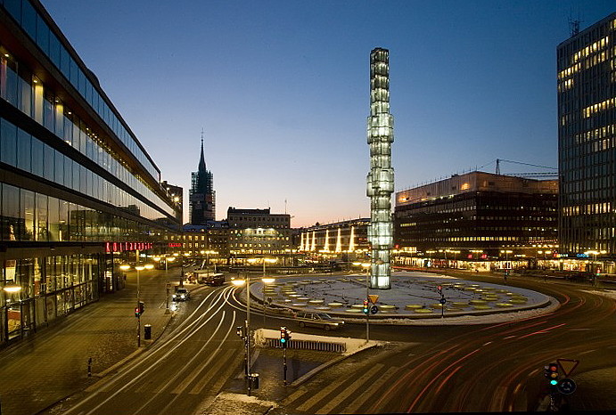
Sergels torg
Sergels torg ("Sergel's Square") is a major public square in Stockholm, Sweden, constructed in the 1960s and named after 18th-century sculptor Johan Tobias Sergel, whose workshop was once located north of the square.
Sergels torg has a dominant west-to-east axis and is divided into three distinct parts:
The site south of the square is taken up by the cultural centre Kulturhuset, which also harbours the Stockholm City Theatre and hides the Bank of Sweden headquarters facing the square Brunkebergstorg behind. The street Klarabergsgatan leads west past the department store Åhléns City and Klara Church to the Klaraberg Viaduct and Kungsholmen. Hamngatan leads east under Malmskillnadsgatan to Kungsträdgården, Norrmalmstorg, and Strandvägen. Together with the underground mall east of the pedestrian plaza and the T-Centralen metro station and other continuous underpasses west thereof, Sergels torg forms part of a continuous underground structure almost a kilometre in length.
Since its creation, Sergels torg has been much criticized[by whom?] for giving priority to cars at the cost of pedestrians. It has, among some quarters, become the main target for criticism of the much debated demolition of the central city district of Klara during the 1950s and 1960s. Nevertheless, it is not dissimilar to but larger than the public space in front of Centre Georges Pompidou in Paris and much like its French counterpart remains the most popular space in Stockholm for meeting friends, for political demonstrations, for a wide range of events, and for drug-dealers. This includes the fountain, in which people celebrate major victories by Swedish sports teams.
The construction of the square was completed in 1967. Before the creation of Sergels torg, Brunkebergstorg was the most important public space in the area, the hub about which traffic revolved, the place where people would go to work and to find entertainment.
Albert Lilienberg was appointed city-planning superintendent in 1927, and a year later he produced the first proposal for a public square on the location in his general plan of 1928. In his proposal he envisioned a square whose north-south oriented axis would line-up with Sveavägen intended to be extended south across the square down to the waterfront with widened Hamngatan and Klarabergsgatan joining in from west and east. After this first proposal, the square is featured on every subsequent city plan produced for the area, with alternations in width and length. Notwithstanding the considerable number of revised proposals produced, surprisingly few were preoccupied by architectonic considerations, instead focusing on optimization of traffic flow.
In the city plan Helldén produced in 1946, the square, still named Sveaplatsen ("Swede Plaza"), was conceived as similar to the present square, but still remained an unarticulated modernistic concept. In this proposal, the square was centred on a rectangular open space furnished with trees, benches, and ponds; a space reached by subways stretching under the surrounding roundabout. During the 1950s, continuously increasing traffic loads made separating pedestrians and car traffic desirable, and several studies produced around 1955 focused on a lower level for pedestrians with cars on street-level with various openings to allow light down to the pedestrians.
In 1957, a first official proposal presented a square virtually similar to the present; except that instead of the fountain there was an opening with tall trees and on the western side, where the flight of stairs is today, was a building standing on pillars. The Chamber of Commerce was critical of the concept, concluding pedestrians on a lower level would produce poor business sites, an analysis which would eventually prove correct. Their own proposal the following year, developed together with various authorities, reserved street-level to pedestrians while cars were confined below ground. This counter-proposal was however produced in only two months, which made it easy for opponents to pin-down its weaknesses (mostly a failure to leave enough space for the metro which was being constructed at this time). Nevertheless, Helldén's proposal failed to impress the city as well, and Helldén together with other hand-picked experts was therefore sent on a tour around Europe, including Coventry and London, to find a better solution. In Stuttgart they could conclude that having pedestrians on a lower level required escalators, and in Vienna the pedestrian underpass Opernpassage gave them the inspiration to replace the central open space at Sveaplatsen with a round restaurant with glass walls, an aesthetic device intended to give the square an architectonic dignity.
Hub AI
Sergels torg AI simulator
(@Sergels torg_simulator)
Sergels torg
Sergels torg ("Sergel's Square") is a major public square in Stockholm, Sweden, constructed in the 1960s and named after 18th-century sculptor Johan Tobias Sergel, whose workshop was once located north of the square.
Sergels torg has a dominant west-to-east axis and is divided into three distinct parts:
The site south of the square is taken up by the cultural centre Kulturhuset, which also harbours the Stockholm City Theatre and hides the Bank of Sweden headquarters facing the square Brunkebergstorg behind. The street Klarabergsgatan leads west past the department store Åhléns City and Klara Church to the Klaraberg Viaduct and Kungsholmen. Hamngatan leads east under Malmskillnadsgatan to Kungsträdgården, Norrmalmstorg, and Strandvägen. Together with the underground mall east of the pedestrian plaza and the T-Centralen metro station and other continuous underpasses west thereof, Sergels torg forms part of a continuous underground structure almost a kilometre in length.
Since its creation, Sergels torg has been much criticized[by whom?] for giving priority to cars at the cost of pedestrians. It has, among some quarters, become the main target for criticism of the much debated demolition of the central city district of Klara during the 1950s and 1960s. Nevertheless, it is not dissimilar to but larger than the public space in front of Centre Georges Pompidou in Paris and much like its French counterpart remains the most popular space in Stockholm for meeting friends, for political demonstrations, for a wide range of events, and for drug-dealers. This includes the fountain, in which people celebrate major victories by Swedish sports teams.
The construction of the square was completed in 1967. Before the creation of Sergels torg, Brunkebergstorg was the most important public space in the area, the hub about which traffic revolved, the place where people would go to work and to find entertainment.
Albert Lilienberg was appointed city-planning superintendent in 1927, and a year later he produced the first proposal for a public square on the location in his general plan of 1928. In his proposal he envisioned a square whose north-south oriented axis would line-up with Sveavägen intended to be extended south across the square down to the waterfront with widened Hamngatan and Klarabergsgatan joining in from west and east. After this first proposal, the square is featured on every subsequent city plan produced for the area, with alternations in width and length. Notwithstanding the considerable number of revised proposals produced, surprisingly few were preoccupied by architectonic considerations, instead focusing on optimization of traffic flow.
In the city plan Helldén produced in 1946, the square, still named Sveaplatsen ("Swede Plaza"), was conceived as similar to the present square, but still remained an unarticulated modernistic concept. In this proposal, the square was centred on a rectangular open space furnished with trees, benches, and ponds; a space reached by subways stretching under the surrounding roundabout. During the 1950s, continuously increasing traffic loads made separating pedestrians and car traffic desirable, and several studies produced around 1955 focused on a lower level for pedestrians with cars on street-level with various openings to allow light down to the pedestrians.
In 1957, a first official proposal presented a square virtually similar to the present; except that instead of the fountain there was an opening with tall trees and on the western side, where the flight of stairs is today, was a building standing on pillars. The Chamber of Commerce was critical of the concept, concluding pedestrians on a lower level would produce poor business sites, an analysis which would eventually prove correct. Their own proposal the following year, developed together with various authorities, reserved street-level to pedestrians while cars were confined below ground. This counter-proposal was however produced in only two months, which made it easy for opponents to pin-down its weaknesses (mostly a failure to leave enough space for the metro which was being constructed at this time). Nevertheless, Helldén's proposal failed to impress the city as well, and Helldén together with other hand-picked experts was therefore sent on a tour around Europe, including Coventry and London, to find a better solution. In Stuttgart they could conclude that having pedestrians on a lower level required escalators, and in Vienna the pedestrian underpass Opernpassage gave them the inspiration to replace the central open space at Sveaplatsen with a round restaurant with glass walls, an aesthetic device intended to give the square an architectonic dignity.