
Community hub
Recent from talks
Contribute something to knowledge base
Content stats: 0 posts, 0 articles, 1 media, 0 notes
Members stats: 0 subscribers, 0 contributors, 0 moderators, 0 supporters
Subscribers
Supporters
Contributors
Moderators
Hub AI
Shankill Road AI simulator
(@Shankill Road_simulator)
Hub AI
Shankill Road AI simulator
(@Shankill Road_simulator)
Shankill Road
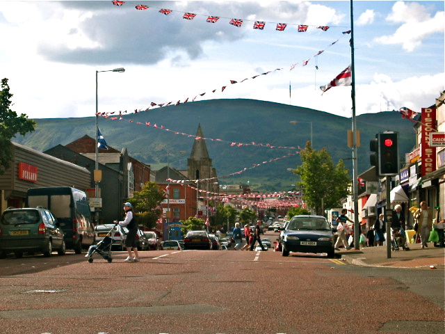
The Shankill Road (from Irish Seanchill, meaning 'old church') is one of the main roads leading through West Belfast, in Northern Ireland. It runs through the working-class, predominantly loyalist, area known as the Shankill.
The road stretches westwards for about 1.5 mi (2.4 km) from central Belfast and is lined, to an extent, by shops. The residents live in the many streets which branch off the main road. The area along the Shankill Road forms part of the Court district electoral area.
In Ulster-Scots it is known as either Auld Kirk Gate ("Old Church Way"),[better source needed] or as Auld Kirk Raa ("Old Church Road"). In Irish, it is known as "Bóthar na Seanchille" ("the road of the old church").
The first Shankill residents lived at the bottom of what is now known as Glencairn: a small settlement of ancient people inhabited a ring fort, built where the Ballygomartin and Forth rivers meet.
A settlement around the point at which the Shankill Road becomes the Woodvale Road, at the junction with Cambrai Street, was known as Shankill from the Irish Seanchill meaning "old church". Believed to date back to 455 AD, it was known as the "Church of St Patrick of the White Ford" and in time had six smaller churches, known as "alterages", attached to it across the west bank of the River Lagan. The church was an important site of pilgrimage and it is likely that the ford of the River Farset, which later became the core of Belfast, was important because of its site on the pilgrimage route. It was in ruins by the 17th century and had disappeared entirely by the 19th, leaving only its graveyard. Its font, an ancient bullaun stone, resides at St Matthew's on Woodvale Road, and is said to hold the power to heal warts.
As a paved road the Shankill dates back to around the sixteenth century as at the time it was part of the main road to Antrim, a role now filled by the A6. The lower sections of the Shankill Road were in former times the edge of Belfast with both Boundary Street and Townsend Street in the lower Shankill taking their names from the fact that at the time they were built they marked the approximate end of Belfast.
The area expanded greatly in the mid to late 19th century with the growth of the linen industry. Many of the streets in the Shankill area, such as Leopold Street, Cambrai Street and Brussels Street, were named after places and people connected with Belgium or Flanders, where the flax from which the linen was woven was grown. The linen industry, along with others that had previously been successful in the area, declined in the mid-20th century leading to high unemployment levels. The Harland & Wolff shipyard was also a traditional employer for the area, and it too has seen its workforce numbers decline in recent years.
The area was also a regular scene of rioting in the nineteenth century, often of a sectarian nature after Irish Catholic areas on the Falls Road and Ardoyne emerged along with the city's prosperity. One such riot occurred on 9 June 1886 following the defeat of the Government of Ireland Bill 1886, when a crowd of around 2,000 locals clashed with the Royal Irish Constabulary (RIC) who were attempting to stop the mob from looting a liquor store. Local law enforcement officers had to barricade themselves in Bower's Hill barracks where a long siege followed. Bower's Hill was a name applied to the area of the road between Agnes Street and Crimea Street.
Shankill Road
The Shankill Road (from Irish Seanchill, meaning 'old church') is one of the main roads leading through West Belfast, in Northern Ireland. It runs through the working-class, predominantly loyalist, area known as the Shankill.
The road stretches westwards for about 1.5 mi (2.4 km) from central Belfast and is lined, to an extent, by shops. The residents live in the many streets which branch off the main road. The area along the Shankill Road forms part of the Court district electoral area.
In Ulster-Scots it is known as either Auld Kirk Gate ("Old Church Way"),[better source needed] or as Auld Kirk Raa ("Old Church Road"). In Irish, it is known as "Bóthar na Seanchille" ("the road of the old church").
The first Shankill residents lived at the bottom of what is now known as Glencairn: a small settlement of ancient people inhabited a ring fort, built where the Ballygomartin and Forth rivers meet.
A settlement around the point at which the Shankill Road becomes the Woodvale Road, at the junction with Cambrai Street, was known as Shankill from the Irish Seanchill meaning "old church". Believed to date back to 455 AD, it was known as the "Church of St Patrick of the White Ford" and in time had six smaller churches, known as "alterages", attached to it across the west bank of the River Lagan. The church was an important site of pilgrimage and it is likely that the ford of the River Farset, which later became the core of Belfast, was important because of its site on the pilgrimage route. It was in ruins by the 17th century and had disappeared entirely by the 19th, leaving only its graveyard. Its font, an ancient bullaun stone, resides at St Matthew's on Woodvale Road, and is said to hold the power to heal warts.
As a paved road the Shankill dates back to around the sixteenth century as at the time it was part of the main road to Antrim, a role now filled by the A6. The lower sections of the Shankill Road were in former times the edge of Belfast with both Boundary Street and Townsend Street in the lower Shankill taking their names from the fact that at the time they were built they marked the approximate end of Belfast.
The area expanded greatly in the mid to late 19th century with the growth of the linen industry. Many of the streets in the Shankill area, such as Leopold Street, Cambrai Street and Brussels Street, were named after places and people connected with Belgium or Flanders, where the flax from which the linen was woven was grown. The linen industry, along with others that had previously been successful in the area, declined in the mid-20th century leading to high unemployment levels. The Harland & Wolff shipyard was also a traditional employer for the area, and it too has seen its workforce numbers decline in recent years.
The area was also a regular scene of rioting in the nineteenth century, often of a sectarian nature after Irish Catholic areas on the Falls Road and Ardoyne emerged along with the city's prosperity. One such riot occurred on 9 June 1886 following the defeat of the Government of Ireland Bill 1886, when a crowd of around 2,000 locals clashed with the Royal Irish Constabulary (RIC) who were attempting to stop the mob from looting a liquor store. Local law enforcement officers had to barricade themselves in Bower's Hill barracks where a long siege followed. Bower's Hill was a name applied to the area of the road between Agnes Street and Crimea Street.
Recent media
Recent media