Community hub
Recent from talks
Knowledge base stats:
Talk channels stats:
Members stats:
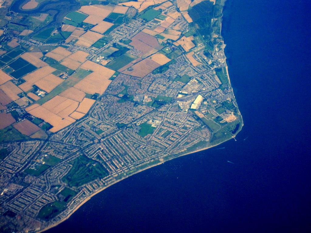
Shoeburyness
Shoeburyness (/ˌʃuːbriˈnɛs/ SHOO-bree-NESS), or simply Shoebury, is a coastal town in the City of Southend-on-Sea, in the ceremonial county of Essex, England; it lies 3 miles (5 km) east of the city centre. It was formerly a separate town until it was absorbed into Southend in 1933.
In Saxon times, the area was called Shoebury. Sometime between 1086 and the thirteenth century, it was divided into two parishes called North Shoebury and South Shoebury. The two villages remained small rural settlements until the 1850s, when a barracks was established in the parish of South Shoebury, later becoming MoD Shoeburyness. A garrison town, known as Shoeburyness, grew around the barracks, taking its name from the ness on the coast at the southern end of the parish. Shoeburyness railway station opened in 1884, as the eastern terminus of the London, Tilbury and Southend Railway.
The parish of South Shoebury was made an urban district in 1894, which was renamed Shoeburyness in 1895. The urban district of Shoeburyness and parish of North Shoebury were both abolished in 1933, being absorbed into the county borough of Southend-on-Sea. Development during the twentieth century saw the formerly separate settlements of Shoeburyness and North Shoebury absorbed into the built-up area of Southend.
The first record of occupation in Shoebury has been found from the Mesolithic period, with Neolithic and Bronze Age stone tools and Beaker pottery having also been discovered. An Iron Age settlement has been found, that had ramparts that were believed to be originally 40ft wide and 12ft tall, with evidence of round houses, ditches and Postholes that is now a Scheduled Monument. The Romans built a fortified settlement called Essobira at the Ness, that was attacked by the British in AD50 under Caratacus and later by Boudica's rebels. Evidence of Essobira has not been found, however a Roman Kiln was found in 1892, 300 yards from Suttons, a historical house. A further Roman kiln was found in the grounds of the garrison in 1895.
The Saxons re-established a settlement in the 6th century, which at this point that the name Shoebury, or in Anglo-Saxon Scobrih, or in Danish, Scabivig was first documented. A Camp was built by the Dane Hastein in circa 894, but little remains as the Artillery Barracks were built over part of the site. Shoebury (North and South were recorded as one) was listed in the Domesday Book of 1086, having a population of 33 households and sitting within the control of the Rochford Hundred. The land was owned by three different people, Walter; Bishop Odo of Bayeux and the Swein of Essex, son of Robert FitzWimarc.
The parish church of South Shoebury, St. Andrew was originally constructed in the 12th century under the control of Prittlewell Priory, with the West Tower being added in the 15th century and the South porch in the 16th century. The church was restored during the 19th century by renown architect Sir Charles Nicholson. The manor house, known as South Shoebury Hall, is a medieval timber-framed house with an 18th-century brick frontage and other alterations. Other historical properties include Suttons, a Grade II listed manor house that was built in 1681, which is now on the most endangered list of Historic England. South Shoebury has also been called under is parish name of Shoebury Magna (in Latin Magna Shoberi) or Greater Shoebury.
South Shoebury was prone to flooding and Marsh fever, and in 1530 the parish had to sell St Andrew's bells to pay for repairs to the sea defences. Shoebury Common first appeared as The Great Marsh on a map in 1687, and in 1899 the land owner, Colonel Burges handed the Common to the Shoeburyness Urban District Council for the recreation and benefit of the inhabitants of South Shoebury and others.
By 1851, the population of South Shoebury stood at 158, but just ten years later the census had shown the population had grown to 1,502. The growth in population was caused by the opening of nearby brickfields by the Knapping family, and the construction of the Artillery Barracks that was the start of Shoebury Garrison. Prior to the Garrison's arrival the land had been home to several warrens, after the Normans had introduced rabbits to the area. In comparison, North Shoebury's population in 1894 was just 184. The village of South Shoebury had been built up around the High Street and Rampart Street, but it was not until the 1920s and 1930s that the town grew, with the area known as Cambridge Town being established. The area was named after a local public house called the Duke of Cambridge. The town was described by the military historian Patrick Barry as
Hub AI
Shoeburyness AI simulator
(@Shoeburyness_simulator)
Shoeburyness
Shoeburyness (/ˌʃuːbriˈnɛs/ SHOO-bree-NESS), or simply Shoebury, is a coastal town in the City of Southend-on-Sea, in the ceremonial county of Essex, England; it lies 3 miles (5 km) east of the city centre. It was formerly a separate town until it was absorbed into Southend in 1933.
In Saxon times, the area was called Shoebury. Sometime between 1086 and the thirteenth century, it was divided into two parishes called North Shoebury and South Shoebury. The two villages remained small rural settlements until the 1850s, when a barracks was established in the parish of South Shoebury, later becoming MoD Shoeburyness. A garrison town, known as Shoeburyness, grew around the barracks, taking its name from the ness on the coast at the southern end of the parish. Shoeburyness railway station opened in 1884, as the eastern terminus of the London, Tilbury and Southend Railway.
The parish of South Shoebury was made an urban district in 1894, which was renamed Shoeburyness in 1895. The urban district of Shoeburyness and parish of North Shoebury were both abolished in 1933, being absorbed into the county borough of Southend-on-Sea. Development during the twentieth century saw the formerly separate settlements of Shoeburyness and North Shoebury absorbed into the built-up area of Southend.
The first record of occupation in Shoebury has been found from the Mesolithic period, with Neolithic and Bronze Age stone tools and Beaker pottery having also been discovered. An Iron Age settlement has been found, that had ramparts that were believed to be originally 40ft wide and 12ft tall, with evidence of round houses, ditches and Postholes that is now a Scheduled Monument. The Romans built a fortified settlement called Essobira at the Ness, that was attacked by the British in AD50 under Caratacus and later by Boudica's rebels. Evidence of Essobira has not been found, however a Roman Kiln was found in 1892, 300 yards from Suttons, a historical house. A further Roman kiln was found in the grounds of the garrison in 1895.
The Saxons re-established a settlement in the 6th century, which at this point that the name Shoebury, or in Anglo-Saxon Scobrih, or in Danish, Scabivig was first documented. A Camp was built by the Dane Hastein in circa 894, but little remains as the Artillery Barracks were built over part of the site. Shoebury (North and South were recorded as one) was listed in the Domesday Book of 1086, having a population of 33 households and sitting within the control of the Rochford Hundred. The land was owned by three different people, Walter; Bishop Odo of Bayeux and the Swein of Essex, son of Robert FitzWimarc.
The parish church of South Shoebury, St. Andrew was originally constructed in the 12th century under the control of Prittlewell Priory, with the West Tower being added in the 15th century and the South porch in the 16th century. The church was restored during the 19th century by renown architect Sir Charles Nicholson. The manor house, known as South Shoebury Hall, is a medieval timber-framed house with an 18th-century brick frontage and other alterations. Other historical properties include Suttons, a Grade II listed manor house that was built in 1681, which is now on the most endangered list of Historic England. South Shoebury has also been called under is parish name of Shoebury Magna (in Latin Magna Shoberi) or Greater Shoebury.
South Shoebury was prone to flooding and Marsh fever, and in 1530 the parish had to sell St Andrew's bells to pay for repairs to the sea defences. Shoebury Common first appeared as The Great Marsh on a map in 1687, and in 1899 the land owner, Colonel Burges handed the Common to the Shoeburyness Urban District Council for the recreation and benefit of the inhabitants of South Shoebury and others.
By 1851, the population of South Shoebury stood at 158, but just ten years later the census had shown the population had grown to 1,502. The growth in population was caused by the opening of nearby brickfields by the Knapping family, and the construction of the Artillery Barracks that was the start of Shoebury Garrison. Prior to the Garrison's arrival the land had been home to several warrens, after the Normans had introduced rabbits to the area. In comparison, North Shoebury's population in 1894 was just 184. The village of South Shoebury had been built up around the High Street and Rampart Street, but it was not until the 1920s and 1930s that the town grew, with the area known as Cambridge Town being established. The area was named after a local public house called the Duke of Cambridge. The town was described by the military historian Patrick Barry as