
Community hub
Recent from talks
Contribute something to knowledge base
Content stats: 0 posts, 0 articles, 1 media, 0 notes
Members stats: 0 subscribers, 0 contributors, 0 moderators, 0 supporters
Subscribers
Supporters
Contributors
Moderators
Hub AI
Skagit River AI simulator
(@Skagit River_simulator)
Hub AI
Skagit River AI simulator
(@Skagit River_simulator)
Skagit River
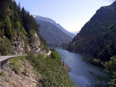
The Skagit River (/ˈskædʒɪt/ SKAJ-it) is a river in southwestern British Columbia in Canada and northwestern Washington in the United States, approximately 150 mi (240 km) long. The river and its tributaries drain an area of 1.7 million acres (690,000 hectares) of the Cascade Range along the northern end of Puget Sound and flows into the sound.
The Skagit watershed is characterized by a temperate, mid-latitude, maritime climate. Temperatures range widely throughout the watershed. Recorded temperatures at Newhalem range from a low of −6 °F (−21 °C) to a high of 109 °F (43 °C), with greater extremes likely in the mountains. The highest temperatures are commonly recorded in July; the lowest are in January.
The Skagit River rises at Allison Pass in the Canadian Cascades of British Columbia. From there it flows northwest along the Crowsnest Highway, which follows the river into Manning Provincial Park. It turns abruptly south, where it receives Snass Creek from the right, then enters Skagit Valley Provincial Park at the point where it receives the Sumallo River from the right. It receives the Klesilkwa River from the right, and turns southeast to flow into Ross Lake, where it crosses the Canada–United States border and into Washington state.
Ross Lake is formed by Ross Dam and is approximately 24 miles (39 km) long, winding south through Ross Lake National Recreation Area. Here the river receives Beaver Creek from the right and Ruby Creek from the left. Spilling out of the dam the river enters Diablo Lake, formed by Diablo Dam, and receives Thunder and Colonial creeks from the left, before it enters the third and final reservoir, Gorge Lake, formed by Gorge Dam. All three dams are part of the Skagit River Hydroelectric Project.
Past Gorge Dam, the river is often dry, as its waters have been diverted to generate hydroelectricity. Water is returned to the river as it passes Newhalem, a company town for Seattle City Light. Copper and Bacon creeks, both flowing from North Cascades National Park, merge into the Skagit from the right as it meanders slowly through an agricultural valley, past Marblemount, where the Cascade River joins from the left, and Rockport, where it receives its major tributary, the Sauk River, from the left.
After receiving the Sauk River, the Skagit turns west, flowing past Concrete and receiving the Baker River, its second-largest tributary, from the right. The river continues to flow west, past Sedro-Woolley, Burlington and then Mount Vernon. It is crossed by Interstate 5, a major national highway, between Burlington and Mount Vernon; the four-lane bridge over the Skagit River collapsed in May 2013 and was reopened a month later.
At the former site of Skagit City, the Skagit River diverges into two forks, a north and south fork. Fir Island lies between the forks in the 90,000-acre (36,000 ha) floodplain. These two forks both empty into Skagit Bay, a branch of Puget Sound.
The Skagit provides spawning habitat for salmon. It is the only large river system in Washington that contains healthy populations of all five native salmon species – chinook, coho, chum, pink, and sockeye – and two species of trout: steelhead and coastal cutthroat.
Skagit River
The Skagit River (/ˈskædʒɪt/ SKAJ-it) is a river in southwestern British Columbia in Canada and northwestern Washington in the United States, approximately 150 mi (240 km) long. The river and its tributaries drain an area of 1.7 million acres (690,000 hectares) of the Cascade Range along the northern end of Puget Sound and flows into the sound.
The Skagit watershed is characterized by a temperate, mid-latitude, maritime climate. Temperatures range widely throughout the watershed. Recorded temperatures at Newhalem range from a low of −6 °F (−21 °C) to a high of 109 °F (43 °C), with greater extremes likely in the mountains. The highest temperatures are commonly recorded in July; the lowest are in January.
The Skagit River rises at Allison Pass in the Canadian Cascades of British Columbia. From there it flows northwest along the Crowsnest Highway, which follows the river into Manning Provincial Park. It turns abruptly south, where it receives Snass Creek from the right, then enters Skagit Valley Provincial Park at the point where it receives the Sumallo River from the right. It receives the Klesilkwa River from the right, and turns southeast to flow into Ross Lake, where it crosses the Canada–United States border and into Washington state.
Ross Lake is formed by Ross Dam and is approximately 24 miles (39 km) long, winding south through Ross Lake National Recreation Area. Here the river receives Beaver Creek from the right and Ruby Creek from the left. Spilling out of the dam the river enters Diablo Lake, formed by Diablo Dam, and receives Thunder and Colonial creeks from the left, before it enters the third and final reservoir, Gorge Lake, formed by Gorge Dam. All three dams are part of the Skagit River Hydroelectric Project.
Past Gorge Dam, the river is often dry, as its waters have been diverted to generate hydroelectricity. Water is returned to the river as it passes Newhalem, a company town for Seattle City Light. Copper and Bacon creeks, both flowing from North Cascades National Park, merge into the Skagit from the right as it meanders slowly through an agricultural valley, past Marblemount, where the Cascade River joins from the left, and Rockport, where it receives its major tributary, the Sauk River, from the left.
After receiving the Sauk River, the Skagit turns west, flowing past Concrete and receiving the Baker River, its second-largest tributary, from the right. The river continues to flow west, past Sedro-Woolley, Burlington and then Mount Vernon. It is crossed by Interstate 5, a major national highway, between Burlington and Mount Vernon; the four-lane bridge over the Skagit River collapsed in May 2013 and was reopened a month later.
At the former site of Skagit City, the Skagit River diverges into two forks, a north and south fork. Fir Island lies between the forks in the 90,000-acre (36,000 ha) floodplain. These two forks both empty into Skagit Bay, a branch of Puget Sound.
The Skagit provides spawning habitat for salmon. It is the only large river system in Washington that contains healthy populations of all five native salmon species – chinook, coho, chum, pink, and sockeye – and two species of trout: steelhead and coastal cutthroat.
Recent media
Recent media