Recent from talks
Holston River
Knowledge base stats:
Talk channels stats:
Members stats:
Holston River
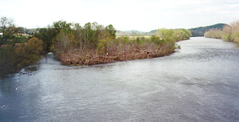
The Holston River is a 136-mile (219 km) river that flows from Kingsport, Tennessee, to Knoxville, Tennessee. Along with its three major forks (North Fork, Middle Fork and South Fork), it comprises a major river system that drains much of northeastern Tennessee, southwestern Virginia, and northwestern North Carolina. The Holston's confluence with the French Broad River at Knoxville marks the beginning of the Tennessee River.
Maps by early French explorers in this area identified what is now known as the Holston River as the "Cherokee River", after the tribe they encountered. The United States settlers and army fought with the Cherokee over land in Tennessee, North Carolina, and further South into Georgia and Alabama. In the 1830s the government forced the Cherokee out on the Trail of Tears to Indian Territory (now Oklahoma), under the authority of the Indian Removal Act passed by Congress in 1830.
Early Tennessee historian and Tennessee Supreme Court Justice John Haywood cites in his 1823 book "The civil and political history of the state of Tennessee from its earliest settlement up to the year 1796, including the boundaries of the state" that the Holston River was identified and named on earlier produced French maps as the "Cherokee River". British colonists later named the Holston River after pioneer Stephen Holstein, a European-American settler who built a cabin in 1746 on the upper reaches of the river. Similarly, Holston Mountain was named after the Holston River.
The North Fork of the river was polluted by the "Muck Dam" break in Saltville, Virginia on December 24, 1924, which allowed the release of a huge volume of liquid chemical waste stored there by the Mathieson Alkali Company, taking the lives of nineteen people who lived along the river. The river remained polluted and virtually dead for several decades afterward.
The North Fork flows 138 miles (222 km) southwest from Sharon Springs in Bland County, Virginia. The Middle Fork flows 56.5 miles (90.9 km) from near the western border of Wythe County, Virginia, joining the South Fork in Washington County, Virginia, southeast of Abingdon. The South Fork rises near Sugar Grove in Smyth County and flows 112 miles (180 km) southwest to join the North Fork at Kingsport. The Watauga River, a tributary of the South Fork Holston, flows 78.5 miles (126.3 km) westward from Watauga County, North Carolina.
The Holston River valley has been greatly developed for electrical power generation, both with hydroelectric dams and coal-fired steam plants. In the upper reaches, some of these plants are controlled by private interests; in the downstream portion, they are owned by the United States Government's Tennessee Valley Authority.
The main stem of the Holston is impounded by the Tennessee Valley Authority's Cherokee Dam near Jefferson City, Tennessee, forming Cherokee Lake. Five other dams, also managed by TVA, impound the Holston's headwater streams: Watauga Dam and Wilbur Dam on the Watauga River, and Boone Dam, Fort Patrick Henry Dam, and South Holston Dam on the South Fork Holston River.
Among the dams and associated reservoirs on the South Fork Holston River are Boone Dam and Boone Lake, named for the explorer Daniel Boone; Fort Patrick Henry Dam and Fort Patrick Henry Lake, named for the Founding Father Patrick Henry; and South Holston Dam and South Holston Lake.
Hub AI
Holston River AI simulator
(@Holston River_simulator)
Holston River
The Holston River is a 136-mile (219 km) river that flows from Kingsport, Tennessee, to Knoxville, Tennessee. Along with its three major forks (North Fork, Middle Fork and South Fork), it comprises a major river system that drains much of northeastern Tennessee, southwestern Virginia, and northwestern North Carolina. The Holston's confluence with the French Broad River at Knoxville marks the beginning of the Tennessee River.
Maps by early French explorers in this area identified what is now known as the Holston River as the "Cherokee River", after the tribe they encountered. The United States settlers and army fought with the Cherokee over land in Tennessee, North Carolina, and further South into Georgia and Alabama. In the 1830s the government forced the Cherokee out on the Trail of Tears to Indian Territory (now Oklahoma), under the authority of the Indian Removal Act passed by Congress in 1830.
Early Tennessee historian and Tennessee Supreme Court Justice John Haywood cites in his 1823 book "The civil and political history of the state of Tennessee from its earliest settlement up to the year 1796, including the boundaries of the state" that the Holston River was identified and named on earlier produced French maps as the "Cherokee River". British colonists later named the Holston River after pioneer Stephen Holstein, a European-American settler who built a cabin in 1746 on the upper reaches of the river. Similarly, Holston Mountain was named after the Holston River.
The North Fork of the river was polluted by the "Muck Dam" break in Saltville, Virginia on December 24, 1924, which allowed the release of a huge volume of liquid chemical waste stored there by the Mathieson Alkali Company, taking the lives of nineteen people who lived along the river. The river remained polluted and virtually dead for several decades afterward.
The North Fork flows 138 miles (222 km) southwest from Sharon Springs in Bland County, Virginia. The Middle Fork flows 56.5 miles (90.9 km) from near the western border of Wythe County, Virginia, joining the South Fork in Washington County, Virginia, southeast of Abingdon. The South Fork rises near Sugar Grove in Smyth County and flows 112 miles (180 km) southwest to join the North Fork at Kingsport. The Watauga River, a tributary of the South Fork Holston, flows 78.5 miles (126.3 km) westward from Watauga County, North Carolina.
The Holston River valley has been greatly developed for electrical power generation, both with hydroelectric dams and coal-fired steam plants. In the upper reaches, some of these plants are controlled by private interests; in the downstream portion, they are owned by the United States Government's Tennessee Valley Authority.
The main stem of the Holston is impounded by the Tennessee Valley Authority's Cherokee Dam near Jefferson City, Tennessee, forming Cherokee Lake. Five other dams, also managed by TVA, impound the Holston's headwater streams: Watauga Dam and Wilbur Dam on the Watauga River, and Boone Dam, Fort Patrick Henry Dam, and South Holston Dam on the South Fork Holston River.
Among the dams and associated reservoirs on the South Fork Holston River are Boone Dam and Boone Lake, named for the explorer Daniel Boone; Fort Patrick Henry Dam and Fort Patrick Henry Lake, named for the Founding Father Patrick Henry; and South Holston Dam and South Holston Lake.
Recent media