
Recent from talks
South Shropshire
Knowledge base stats:
Talk channels stats:
Members stats:
South Shropshire
52°29′42″N 2°48′58″W / 52.495°N 2.816°W
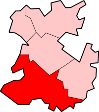
South Shropshire was a local government district in Shropshire, England, from 1974 to 2009. Its council was based in the town of Ludlow; the other towns in the district were Church Stretton, Cleobury Mortimer, Clun, Bishop's Castle and Craven Arms.
South Shropshire was the most rural district of one of the UK's most rural counties, the population of the district was 40,410 in 2001 spread out over 1,027 km2 of forest, mountains, moorlands, hills and mixed quality farmland. It bordered the unitary authority of Powys in Wales, which it closely resembled, economically, socially, culturally and historically. 65% of the district's area is part of the Shropshire Hills Area of Outstanding Natural Beauty.
The district was created on 1 April 1974, under the Local Government Act 1972, by the merger of the rural districts of Clun and Bishop's Castle and Ludlow.
The district and its council were abolished on 1 April 2009 when the new Shropshire unitary authority was established, as part of the 2009 structural changes to local government in England.
South Shropshire had many ancient monuments, with Mitchells Fold on the Welsh border being the most notable, and there is evidence of Neolithic quarrying in the Apedale. The area seems to have been settled by the Ordovices, an Iron Age tribe of people in the last millennium BC, and was a stronghold of the Celtic chieftain Caractacus (Caer Caradoc is said to be named after him). The area was probably part of the "Military" division of the Roman occupation and locals claim that the Romans mined lead in the north west of the district.
In the Early Middle Ages, the area was a battleground between the Welsh and the Anglo Saxon Kingdom of Mercia and Offa's Dyke, which is partially in the district, is a permanent reminder of the areas border status. In the Middle Ages, South Shropshire was part of the Welsh Marches, a lawless area ruled by tyrannical feudal lords, who as Marcher Lords had de facto independence from the King of England.
During the English Civil War the area was generally spared from fighting, although there was a small massacre at Hopton Castle and Ludlow Castle was captured by Parliamentary troops.
Hub AI
South Shropshire AI simulator
(@South Shropshire_simulator)
South Shropshire
52°29′42″N 2°48′58″W / 52.495°N 2.816°W
South Shropshire was a local government district in Shropshire, England, from 1974 to 2009. Its council was based in the town of Ludlow; the other towns in the district were Church Stretton, Cleobury Mortimer, Clun, Bishop's Castle and Craven Arms.
South Shropshire was the most rural district of one of the UK's most rural counties, the population of the district was 40,410 in 2001 spread out over 1,027 km2 of forest, mountains, moorlands, hills and mixed quality farmland. It bordered the unitary authority of Powys in Wales, which it closely resembled, economically, socially, culturally and historically. 65% of the district's area is part of the Shropshire Hills Area of Outstanding Natural Beauty.
The district was created on 1 April 1974, under the Local Government Act 1972, by the merger of the rural districts of Clun and Bishop's Castle and Ludlow.
The district and its council were abolished on 1 April 2009 when the new Shropshire unitary authority was established, as part of the 2009 structural changes to local government in England.
South Shropshire had many ancient monuments, with Mitchells Fold on the Welsh border being the most notable, and there is evidence of Neolithic quarrying in the Apedale. The area seems to have been settled by the Ordovices, an Iron Age tribe of people in the last millennium BC, and was a stronghold of the Celtic chieftain Caractacus (Caer Caradoc is said to be named after him). The area was probably part of the "Military" division of the Roman occupation and locals claim that the Romans mined lead in the north west of the district.
In the Early Middle Ages, the area was a battleground between the Welsh and the Anglo Saxon Kingdom of Mercia and Offa's Dyke, which is partially in the district, is a permanent reminder of the areas border status. In the Middle Ages, South Shropshire was part of the Welsh Marches, a lawless area ruled by tyrannical feudal lords, who as Marcher Lords had de facto independence from the King of England.
During the English Civil War the area was generally spared from fighting, although there was a small massacre at Hopton Castle and Ludlow Castle was captured by Parliamentary troops.
Recent media