
Community hub
Recent from talks
Contribute something to knowledge base
Content stats: 0 posts, 0 articles, 1 media, 0 notes
Members stats: 0 subscribers, 0 contributors, 0 moderators, 0 supporters
Subscribers
Supporters
Contributors
Moderators
Hub AI
Taal Lake AI simulator
(@Taal Lake_simulator)
Hub AI
Taal Lake AI simulator
(@Taal Lake_simulator)
Taal Lake
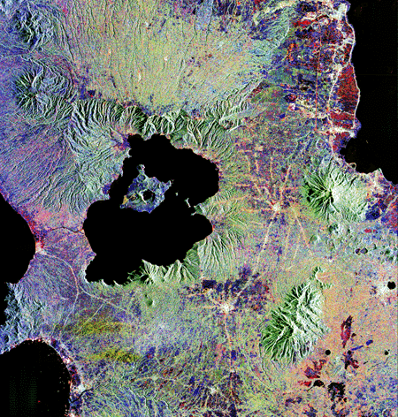
Taal Lake (Tagalog: Lawà ng Taál, IPA: [taʔal], older name: Bombón Lake) is a freshwater caldera lake in the province of Batangas, on the island of Luzon in the Philippines. The lake fills Taal Volcano, a large volcanic caldera formed by very large eruptions between 500,000 and 100,000 years ago.
It is the country's third-largest lake, after Laguna de Bay and Lake Lanao. Volcano Island, the location of Taal Volcano's historical eruptions and responsible for the lake's sulphur content, lies near the center of the lake.
There is a crater lake on Volcano Island. It was known as Yellow Lake and contains its own small islet, Vulcan Point. Vulcan Point is one of the few third-order islands in the world.
The Taal Lake basin was first declared as a national park, known as the Taal Volcano National Park, by Proclamation No. 235 on July 22, 1967, covering 62,292 hectares (153,930 acres).
Under Republic Act No. 7586 (the National Integrated Protected Areas System Act of 1992), the area was reestablished as the Taal Volcano Protected Landscape by Proclamation No. 906 on October 16, 1996. The protected area is managed by a Protected Area Management Board (PAMB) and has a Chief Operating Officer called a Protected Area Superintendent. A Management Plan was crafted and approved by the PAMB in 2009 and now serves as the blueprint for the lake’s conservation.
Taal Lake was once an inlet of nearby Balayan Bay, and was easily navigable from it. A series of major eruptions in the early 18th century battered lakeside towns with earthquakes and volcanic debris. This activity culminated in 1754 with Taal Volcano's largest eruption that blocked Pansipit River with tephra, narrowing the lake's sole outlet to the sea. This caused the lake’s waters to rise, eventually submerging several towns along its shore – the remnants of which are reportedly visible underwater to this day. Since the 1754 eruption, the lake’s surface elevation had risen from sea level to 5 metres (16 ft) above sea level, and its saline waters becoming brackish and eventually freshwater after centuries of precipitation.
The poblaciones (town centres) of Lipa, Taal, Sala, Bauan, and Tanauan were abandoned and reestablished several kilometers away from the lakeshore after volcanic activity had subsided. In the century since, newer settlements along the lakeshore were carved from the larger towns: Talisay (established 1869, from Taal), Cuenca (1877, from San José), Alitagtag (1910, from Bauan), Mataasnakahoy (1932, from Lipa), Agoncillo (1949, from Lemery), San Nicolas (1955, over the ruins of old Taal), Santa Teresita (1961, from Taal, San Luis, and San Nicolas), Laurel (1969, from Talisay) and Balete (1969, from Lipa).
As the lake was previously connected to the sea, it is home to many endemic species that have evolved and adapted to the desalination of the lake's waters. The lake has a freshwater-adapted population of trevally, Caranx ignobilis. This fish, also found in Pansipit River, is locally called maliputo. Its most popular endemic species is the overharvested Sardinella tawilis, a freshwater sardine. The two other endemic fish species in Taal Lake are the gobies Gnatholepis volcanus and Rhinogobius flavoventris.
Taal Lake
Taal Lake (Tagalog: Lawà ng Taál, IPA: [taʔal], older name: Bombón Lake) is a freshwater caldera lake in the province of Batangas, on the island of Luzon in the Philippines. The lake fills Taal Volcano, a large volcanic caldera formed by very large eruptions between 500,000 and 100,000 years ago.
It is the country's third-largest lake, after Laguna de Bay and Lake Lanao. Volcano Island, the location of Taal Volcano's historical eruptions and responsible for the lake's sulphur content, lies near the center of the lake.
There is a crater lake on Volcano Island. It was known as Yellow Lake and contains its own small islet, Vulcan Point. Vulcan Point is one of the few third-order islands in the world.
The Taal Lake basin was first declared as a national park, known as the Taal Volcano National Park, by Proclamation No. 235 on July 22, 1967, covering 62,292 hectares (153,930 acres).
Under Republic Act No. 7586 (the National Integrated Protected Areas System Act of 1992), the area was reestablished as the Taal Volcano Protected Landscape by Proclamation No. 906 on October 16, 1996. The protected area is managed by a Protected Area Management Board (PAMB) and has a Chief Operating Officer called a Protected Area Superintendent. A Management Plan was crafted and approved by the PAMB in 2009 and now serves as the blueprint for the lake’s conservation.
Taal Lake was once an inlet of nearby Balayan Bay, and was easily navigable from it. A series of major eruptions in the early 18th century battered lakeside towns with earthquakes and volcanic debris. This activity culminated in 1754 with Taal Volcano's largest eruption that blocked Pansipit River with tephra, narrowing the lake's sole outlet to the sea. This caused the lake’s waters to rise, eventually submerging several towns along its shore – the remnants of which are reportedly visible underwater to this day. Since the 1754 eruption, the lake’s surface elevation had risen from sea level to 5 metres (16 ft) above sea level, and its saline waters becoming brackish and eventually freshwater after centuries of precipitation.
The poblaciones (town centres) of Lipa, Taal, Sala, Bauan, and Tanauan were abandoned and reestablished several kilometers away from the lakeshore after volcanic activity had subsided. In the century since, newer settlements along the lakeshore were carved from the larger towns: Talisay (established 1869, from Taal), Cuenca (1877, from San José), Alitagtag (1910, from Bauan), Mataasnakahoy (1932, from Lipa), Agoncillo (1949, from Lemery), San Nicolas (1955, over the ruins of old Taal), Santa Teresita (1961, from Taal, San Luis, and San Nicolas), Laurel (1969, from Talisay) and Balete (1969, from Lipa).
As the lake was previously connected to the sea, it is home to many endemic species that have evolved and adapted to the desalination of the lake's waters. The lake has a freshwater-adapted population of trevally, Caranx ignobilis. This fish, also found in Pansipit River, is locally called maliputo. Its most popular endemic species is the overharvested Sardinella tawilis, a freshwater sardine. The two other endemic fish species in Taal Lake are the gobies Gnatholepis volcanus and Rhinogobius flavoventris.
Recent media
Recent media