
Community hub
Recent from talks
Contribute something
Nothing was collected or created yet.
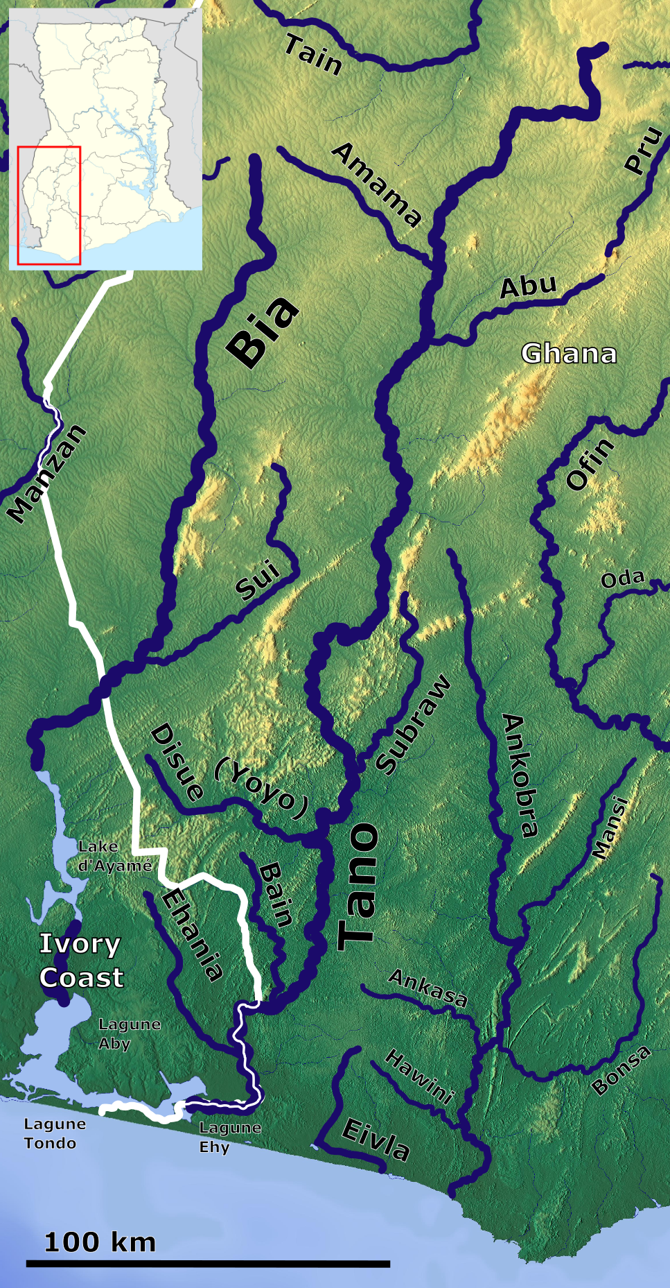
Tano River
View on Wikipedia| Tano River Rivière Tanoé | |
|---|---|
 | |
 South Ghana with the Tano | |
| Location | |
| Countries | Ghana and Ivory Coast |
| Physical characteristics | |
| Mouth | Atlantic Ocean |
• coordinates | 7°37′50″N 1°53′58″W / 7.63056°N 1.89944°W |
| Length | 400 km (250 mi) |
| Discharge | |
| • location | Mouth |
| Basin features | |
| [1] | |
The Tano or Tanoé River (French: Rivière Tano) is a river in Ghana. It flows for 400 kilometres from a town called Traa, a suburb of Techiman, the capital town of Bono East Region in the Republic of Ghana to Ehy Lagoon, Tendo Lagoon and finally Aby Lagoon in Ivory Coast where it enters the Atlantic Ocean. The river Tano forms the last few kilometres of the international land boundary between Ghana and Ivory Coast.[2][3] [4]
Indigenous local beliefs of Bono holds that, Taakora, the highest of the Bono gods on Earth, lives at the source of the river.[5]
The last few individuals of Miss Waldron's Red Colobus (Piliocolobus badius waldronae), one of the world's most threatened primates, are believed to live in the forest between the river and Ehy Lagoon.[6] As of mid-2008, this area is slated for logging by Unilever, with the aim to replace it with oil palm plantations.[7][2]
In January of 2020, a truck with loads of sulfuric acid plunged into the Tano river. On January 13 the people were advised not to drink the water because of contamination. The river has since been restored to its natural state.[8]
See also
[edit]Footnotes
[edit]- ^ Konadu, Kwasi; Campbell, Clifford C. (2016). The Ghana Reader. Durham. North Carolina and London, England: Duke University. pp. 39–40. ISBN 978-0-8223-5992-0.
- ^ a b Tano Basin. Water Resources Commission of Ghana.
- ^ Asare‑Donkor, Noah Kyame; Adimado, Anthony Apeke (2016). "Influence of mining related activities on levels of mercury in water, sediment and fish from the Ankobra and Tano River basins in South Western Ghana" (PDF). Environmental Systems Research.
- ^ Gbadamosi, Nosmot (28 January 2020). "Ghana's Bauxite Boom". Foreign Policy.
- ^ Tano River Archived 2013-02-16 at the Wayback Machine. patachu.com.
- ^ McGraw (2005)
- ^ Wolzer (2008)
- ^ "Poisoned Tano River Restored – GWCL". Modern Ghana.
References
[edit]- McGraw, W. Scott (2005): Update on the Search for Miss Waldron's Red Colobus Monkey. International Journal of Primatology 26(3): 605–619. doi:10.1007/s10764-005-4368-9 (HTML abstract)
- Wolzer, Chris (2008): Tanoé Swamps Forest destruction by Unilever[permanent dead link]. Version of 2008-MAY-28. Retrieved 2008-JUN-24.