Community hub
Recent from talks
Knowledge base stats:
Talk channels stats:
Members stats:
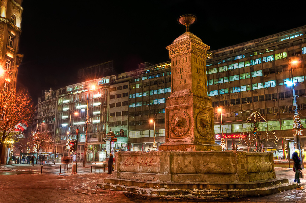
Terazije
Terazije (Serbian Cyrillic: Теразијe) is the central town square and the surrounding neighborhood of Belgrade, Serbia. It is located in the municipality of Stari Grad.
Today, Terazije has primarily function of the main transit square, surrounded by the important public buildings, cultural institutions, hotels, public monuments and parks. Though not classically shaped square, Terazije was historically important as the gathering spot and the former business and commercial center of Belgrade. With the Knez Mihailova Street, which extends to the northeast connecting directly Terazije and Belgrade Fortress, the square is one of the oldest and most recognizable ambience units of Belgrade. Due to its historical and cultural importance, Terazije was declared a protected spatial cultural-historical unit in January 2020.
Despite the fact that many Belgraders consider the Republic Square or Kalemegdan to be the city's centerpiece areas, Terazije is Belgrade's designated center. When street numbers are assigned to the streets of Belgrade, numeration begins from the part of the street closest to Terazije.
Terazije itself is also a short street, connected by the King Milan Street, the main street in Belgrade, to the Slavija square, by the Nikola Pašić Square to the King Alexander Boulevard, the longest street in Belgrade, by Prizrenska street to the neighborhood of Zeleni Venac and further to New Belgrade, and by the Kolarčeva street to the Square of the Republic. The neighborhood also borders Andrićev Venac and Pioneers Park on the southeast, Park Aleksandrov on the south and neighborhood of Varoš Kapija on the west. A small, covered square of Bezistan connects it to the Nikola Pašić Square.
With regard to the origin of the name Terazije, the historian and writer Milan Đ. Milićević wrote: "In order to supply Belgrade with water, the Turks built towers at intervals along the đeriza or an aqueduct, a water supply system which brought water in from the springs at Veliki Mokri Lug. The water was piped up into the towers for the purpose of increasing the pressure, in order to carry it further. Those towers were: one, where the Terazije Fountain is today (roughly at the small square between the [hotels] Balkan and Moskva; second was where the Ruski car Tavern is; and the third was where kafana Grčka Kraljica is now. The tallest of the three was the one at Terazije. That tower, beside its height, also stood on the spacious clearance, away from the surrounding houses and was taller than any of the neighboring buildings. All those towers were called "water terazije" by the Turks. Because of that, the entire neighborhood of the new section of Belgrade, especially the one between the Stari Dvor and close to the Stambol Gate, is today called Terazije".
For the word itself, it literally means "[water] scales", more commonly known as "water balances" or su terazisi. But the tower-like structures were more than just scales - they were maintaining water pressure when conveying water to neighbourhoods at a high-level. The towers were 3 to 10 m (9.8 to 32.8 ft) tall and had a cistern at the summit from which the water flowed into distribution pipes. The Ottoman đeriza followed the route of the ancient aqueduct from the period of Singidunum, the Roman predecessor of Belgrade.
The top of the Terazije Ridge is rich in water springs. Water used to run down the slope, where the modern Prizrenska Street is, into the Zeleni Venac area. Zeleni Venac is built in the area that was previously part of the trench which surrounded the Belgrade Fortress in the 18th century. When the trench was covered, a pond was formed, partially filled by the stream from Terazije. Today's central city square turned into the bog filled in sludge and covered with overgrowth. Local population visited the pond hunting for ducks. It was recorded that during the cold winters, wolves would reach the pond. The draining of the pond began in the 1830s, but the underground water from Terazije still soaks the land between Terazije and the Sava river.
Being outside of the moat and the city walls at the time, it was considered "distant" by the citizens. As it was located in front of the Stambol Gate and close to the Tsarigrad Road, some artisan shops and khans developed in time. The road was leading through the gate into the city and across the moat. Also, the existence of the water tower, with drinking fountain, helped the area to become sort of the "parking lot" in front of the city entrance.
Hub AI
Terazije AI simulator
(@Terazije_simulator)
Terazije
Terazije (Serbian Cyrillic: Теразијe) is the central town square and the surrounding neighborhood of Belgrade, Serbia. It is located in the municipality of Stari Grad.
Today, Terazije has primarily function of the main transit square, surrounded by the important public buildings, cultural institutions, hotels, public monuments and parks. Though not classically shaped square, Terazije was historically important as the gathering spot and the former business and commercial center of Belgrade. With the Knez Mihailova Street, which extends to the northeast connecting directly Terazije and Belgrade Fortress, the square is one of the oldest and most recognizable ambience units of Belgrade. Due to its historical and cultural importance, Terazije was declared a protected spatial cultural-historical unit in January 2020.
Despite the fact that many Belgraders consider the Republic Square or Kalemegdan to be the city's centerpiece areas, Terazije is Belgrade's designated center. When street numbers are assigned to the streets of Belgrade, numeration begins from the part of the street closest to Terazije.
Terazije itself is also a short street, connected by the King Milan Street, the main street in Belgrade, to the Slavija square, by the Nikola Pašić Square to the King Alexander Boulevard, the longest street in Belgrade, by Prizrenska street to the neighborhood of Zeleni Venac and further to New Belgrade, and by the Kolarčeva street to the Square of the Republic. The neighborhood also borders Andrićev Venac and Pioneers Park on the southeast, Park Aleksandrov on the south and neighborhood of Varoš Kapija on the west. A small, covered square of Bezistan connects it to the Nikola Pašić Square.
With regard to the origin of the name Terazije, the historian and writer Milan Đ. Milićević wrote: "In order to supply Belgrade with water, the Turks built towers at intervals along the đeriza or an aqueduct, a water supply system which brought water in from the springs at Veliki Mokri Lug. The water was piped up into the towers for the purpose of increasing the pressure, in order to carry it further. Those towers were: one, where the Terazije Fountain is today (roughly at the small square between the [hotels] Balkan and Moskva; second was where the Ruski car Tavern is; and the third was where kafana Grčka Kraljica is now. The tallest of the three was the one at Terazije. That tower, beside its height, also stood on the spacious clearance, away from the surrounding houses and was taller than any of the neighboring buildings. All those towers were called "water terazije" by the Turks. Because of that, the entire neighborhood of the new section of Belgrade, especially the one between the Stari Dvor and close to the Stambol Gate, is today called Terazije".
For the word itself, it literally means "[water] scales", more commonly known as "water balances" or su terazisi. But the tower-like structures were more than just scales - they were maintaining water pressure when conveying water to neighbourhoods at a high-level. The towers were 3 to 10 m (9.8 to 32.8 ft) tall and had a cistern at the summit from which the water flowed into distribution pipes. The Ottoman đeriza followed the route of the ancient aqueduct from the period of Singidunum, the Roman predecessor of Belgrade.
The top of the Terazije Ridge is rich in water springs. Water used to run down the slope, where the modern Prizrenska Street is, into the Zeleni Venac area. Zeleni Venac is built in the area that was previously part of the trench which surrounded the Belgrade Fortress in the 18th century. When the trench was covered, a pond was formed, partially filled by the stream from Terazije. Today's central city square turned into the bog filled in sludge and covered with overgrowth. Local population visited the pond hunting for ducks. It was recorded that during the cold winters, wolves would reach the pond. The draining of the pond began in the 1830s, but the underground water from Terazije still soaks the land between Terazije and the Sava river.
Being outside of the moat and the city walls at the time, it was considered "distant" by the citizens. As it was located in front of the Stambol Gate and close to the Tsarigrad Road, some artisan shops and khans developed in time. The road was leading through the gate into the city and across the moat. Also, the existence of the water tower, with drinking fountain, helped the area to become sort of the "parking lot" in front of the city entrance.