Recent from talks
Nothing was collected or created yet.
Thenmala Dam
View on Wikipedia
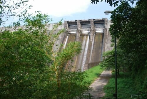
The Thenmala Dam also known as Parappar Dam is part of the largest irrigation project in Kerala, India. It is built along Kallada River in Kollam district of Kerala. The reservoir is used for irrigation and power generation.
Key Information
The dam project started in the 1960s under the Kallada Irrigation and Tree Crop development project.[1] The foundation stone of the dam was laid by T. K. Divakaran on 26 January 1972. It was completed in 1986 and was commissioned on 26 May 1986 by K. Karunakaran along with Kallada Irrigation Project. The reservoir is now a part of Thenmala Ecotourism Project.[2]
Location and Geography
[edit]The dam site is in the confluence of three major tributaries of Kallada River namely Kulathupuzha river which arises from various streams originating in Ponmudi hills, Parappar river which originates from streams originating on Windward side of Agasthyamala Biosphere Reserve and Shendurney river originating from streams near Aryankavu - Sengottai Pass. The gravity dam opens up to downstream that flow westward towards Punalur.
The dam is situated 65 km east of Kollam, 72 km north of Thiruvananthapuram and 39 km west of Tenkasi.
Kallada Irrigation Project
[edit]The KIP Project (Kallada Irrigation and Tree Crop development project) started with an original cost of Rs. 13.28 crores. The revised estimate of project is Rs. 728 crores (at the 1999 schedule of rates) and made cost escalation to the tune of 5,356 percent. The ayacut[3] targeted was 61,630 hectares (net) and 92,800 hectares (gross) but the achieved target was below 50,000 hectares[4] Though the project was targeted for completion, and priority in allocation was given during the Ninth Plan, it could not be completed and commissioned fully.[5]
Thenmala Ecotourism
[edit]India's first planned Ecotourism was started around the reservoir in 1998. The ecotourism project uses reservoir as an ecotourism destination, with boating available, trekking and adventure activities on Shendurney Wildlife Sanctuary that surrounds the reservoir.[6][7]
See also
[edit]References
[edit]- ^ "Announcement of World Bank and IDA to Support First Irrigation Project in India Using Underground Plastic Pipes on June 28, 1982". World Bank. Retrieved 30 May 2024.
- ^ "Thenmala - India's first planned Ecotourism destination, Kollam". Kerala Tourism. Retrieved 30 May 2024.
- ^ ayacut: The area served by an irrigation project such as a canal, dam or a tank.
- ^ "Kerala Irrigation Department". Retrieved 19 September 2014.
- ^ "www.kollam.nic.in". Retrieved 19 September 2014.
- ^ tripuntold - "Thenmala Dam", Retrieved on 09 July 2020.
- ^ "Thenmala - India's first planned Eco-Tourism, Kollam - Kerala Tourism". Retrieved 20 September 2014.
External links
[edit]Thenmala Dam
View on GrokipediaHistory
Planning and Initiation
The Thenmala Dam, also known as Parappar Dam, was planned as the central reservoir component of the Kallada Irrigation and Tree Crop Development Scheme, Kerala's largest irrigation initiative, intended to supply water for modernizing agriculture across approximately 37,600 hectares of paddy and hillside lands in Kollam and Pathanamthitta districts, thereby enhancing productivity and farmer incomes through integrated irrigation and treecrop support.[7] The scheme emphasized gravity-based water distribution from a masonry dam on the Kallada River to mitigate seasonal shortages in a region with undulating terrain and monsoon-dependent hydrology.[1] Planning originated in the late 1950s amid post-independence pushes for self-reliant agriculture in Kerala, culminating in government approval for the project's launch under state irrigation authorities, with early feasibility assessments focusing on the site's topography at Parappar near Thenmala for optimal storage and minimal environmental disruption to the forested catchment.[8] Initial estimates projected a cost of Rs. 13.28 crores for the dam and ancillary works, reflecting ambitions to harness the Kallada basin's 689 square kilometer catchment for year-round cultivation of rice, rubber, and other cash crops.[9] Initiation marked the formal start of groundwork in 1961, transitioning from surveys to site preparation, though delays in funding and land acquisition extended the pre-construction phase.[10] The foundation stone was laid on 26 January 1972 by T. K. Divakaran, then serving in a key state capacity, symbolizing commitment to the project's irrigation goals despite escalating costs that later required revisions.[11] This phase underscored causal linkages between dam storage and downstream command area viability, prioritizing empirical hydrological data over expansive social programs.[12]Construction Phase
The construction of Thenmala Dam commenced in 1972 as part of the Kallada Irrigation and Tree Crop Development Scheme, Kerala's largest irrigation project.[13] The foundation stone was laid on 26 January 1972 by T. K. Divakaran, then Minister for Irrigation in Kerala.[14] Although broader project planning traces back to 1961 with an initial cost estimate of ₹13.28 crores, on-site dam building aligned with the 1972 start, reflecting phased implementation typical of large-scale infrastructure in the region.[1] The dam's design as a straight gravity masonry structure with an integrated spillway necessitated extensive earthworks, stone masonry placement, and concrete pouring across a 335-meter crest length.[13] Progress involved sequential phases of foundation excavation, embankment stabilization, and spillway integration, drawing on local aggregates and labor amid the forested terrain of the Western Ghats.[14] By the mid-1980s, structural completion allowed for reservoir impoundment testing, though the overall Kallada project faced delays from hydrological surveys and land acquisition.[15] Cost escalations were pronounced, with revised estimates reaching ₹728 crores by 1999 schedule rates due to inflation, material price hikes, and extended timelines exceeding two decades from inception.[9] No major engineering failures were reported during erection, but the phase underscored challenges in coordinating masonry gravity dam stability with the Kallada River's seasonal flows.[13] The effort employed conventional construction techniques without noted reliance on foreign contractors, prioritizing state-led execution under the Kerala Irrigation Department.[1] Completion of the dam body occurred in May 1986, marking the end of the primary construction phase and enabling transition to commissioning.[13] This timeline positioned Thenmala as a key node in regional water security, though subsequent canal networks extended project delays beyond the dam itself.[9]Commissioning and Early Operations
The Thenmala Dam was commissioned in 1986, marking the operational start of the Kallada Irrigation Project's primary storage infrastructure.[1] The formal inauguration occurred on 26 May 1986, conducted by K. Karunakaran, then Chief Minister of Kerala, integrating the dam with the broader irrigation network designed to harness the Kallada River's flow.[11] In its initial years, the reservoir's primary function centered on accumulating monsoon inflows to support gravity-fed irrigation releases via downstream canals, targeting paddy lands and tree crops across approximately 68,000 hectares in Kollam and adjacent districts.[8] Water management emphasized seasonal storage and controlled outflows to mitigate flood risks while prioritizing agricultural needs, aligning with the project's original mandate for reliable supply to hillside gardens and lowlands.[7] Early releases facilitated initial crop cycles, though full canal network utilization progressed gradually amid ongoing project expansions.[1] Hydropower integration followed separately, with the adjacent Kallada Hydro Electric Project—exploiting irrigation tailwaters—achieving commissioning of its 7.5 MW units in November 1993 and September 1994, dedicating the facility to the nation on 5 January 1994.[4] This downstream setup represented Kerala's inaugural use of irrigation releases for power generation, augmenting the dam's multifunctional role without disrupting early irrigation priorities.[16]Geography and Hydrology
Location and Catchment Area
The Thenmala Dam, also referred to as Parappar Dam, is situated in Thenmala village, Kollam district, Kerala, India, across the Kallada River at Parappar.[1] It lies approximately 19 kilometers from Punalur town and 2 kilometers from Thenmala railway station, at the foothills of the Western Ghats mountain range.[1] The dam's geographical coordinates are approximately 8°57′N 77°04′E, with the site situated about 160 meters above sea level.[17] [18] The catchment area upstream of the Thenmala Dam covers 549 square kilometers (212 square miles), primarily consisting of hilly terrain in the Western Ghats that feeds the Kallada River and its tributaries.[11] This area includes forested regions and contributes to the reservoir's water inflow, supporting irrigation and hydropower functions within the Kallada Irrigation Project.[1] The reservoir formed by the dam has a surface area of approximately 23 square kilometers when full.[11]Kallada River Integration
The Thenmala Dam, constructed as a straight gravity masonry structure across the Kallada River at Parappar near Thenmala in Kollam district, serves as the primary impoundment point for the river's upper basin waters. Positioned at approximately 8°57' N latitude, the dam captures inflows from the Kallada River's catchment, which includes converging tributaries such as the Kulathupuzha, Parappar, and Chendurny rivers, enabling storage of monsoon-seasonal runoff for downstream utilization.[1][11] This integration regulates the Kallada River's natural flow regime by storing excess water in the reservoir during high-rainfall periods and facilitating controlled releases thereafter, which supports irrigation canals and a 50 MW hydroelectric power station integrated with the dam. Tailrace waters from the power generation facility are discharged back into the Kallada River, preserving a modified base flow while reducing peak discharges and hydrologic variability compared to pre-dam conditions.[19][20] The dam's reservoir has trapped sediments since its commissioning in 1986, substantially decreasing downstream sediment delivery to the Kallada River estuary and coastal areas, which has contributed to altered geomorphic processes and potential saltwater intrusion exacerbated by reduced freshwater outflows. Such hydrological modifications underscore the dam's central role in reshaping the Kallada River's ecological and sediment dynamics.[21][22][1]Design and Technical Specifications
Structural Features
The Thenmala Dam is a straight gravity masonry dam constructed across the Kallada River near Parappar in Kollam District, Kerala.[1] Its total length measures 335 meters, with a maximum height of 85.35 meters from the deepest foundation level at +106.39 meters to the crest at +118.90 meters.[1] The structure consists of 12 serially numbered masonry blocks, including two non-overflow masonry sections positioned on either side of the central spillway.[1] The spillway is a gated ogee type with three radial gates, each 12.19 meters wide and 9.14 meters high, spanning 42.06 meters in total length to manage flood discharges.[1] The main dam body utilizes masonry materials designed to resist water pressure through its weight and stability as a gravity structure.[1] [23] An auxiliary earthen saddle dam, constructed with impervious fill, supplements the main structure, extending 225.7 meters in length and reaching a maximum height of 12.51 meters.[1] This earthen component addresses topographic variations in the saddle area, ensuring containment of the reservoir without reliance on the primary masonry section.[1]Reservoir and Capacity Details
The Thenmala Dam impounds a reservoir with a gross storage capacity of 524 million cubic meters (Mm³) at full reservoir level (FRL).[24] This increases to 536 Mm³ at maximum water level (MWL).[24] Live storage at FRL stands at 507 Mm³, while dead storage capacity is 17 Mm³.[24] The reservoir's catchment area measures approximately 542 square kilometers (km²).[25] The FRL is maintained at 115.82 meters above mean sea level, with MWL reaching 116.73 meters.[25] These capacities support the Kallada Irrigation Project's objectives by storing monsoon inflows from the Kallada River basin for regulated release during dry periods.[14]| Parameter | Value |
|---|---|
| Gross Storage at FRL | 524 Mm³ |
| Gross Storage at MWL | 536 Mm³ |
| Live Storage at FRL | 507 Mm³ |
| Dead Storage | 17 Mm³ |
| Catchment Area | 542 km² |
| Full Reservoir Level | 115.82 m |
| Maximum Water Level | 116.73 m |

