Recent from talks
Nothing was collected or created yet.
Tidworth
View on Wikipedia
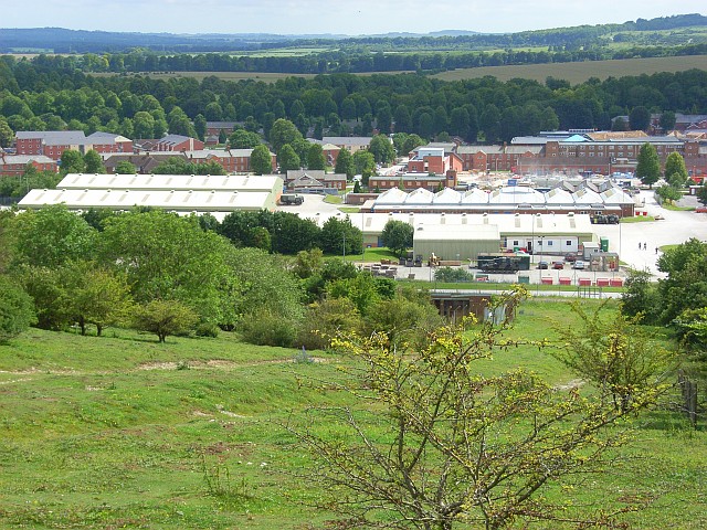
Tidworth is a garrison town and civil parish in south-east Wiltshire, England, on the eastern edge of Salisbury Plain. Lying on both sides of the A338 about 3+1⁄2 miles (5.6 km) north of the A303 primary route, the town is approximately 8 miles (13 km) west of Andover, 12 miles (19 km) south of Marlborough, and 13 miles (21 km) north by north-east of Salisbury. The population of the parish at the 2011 census was approximately 10,600.[2]
Key Information
Originally two villages – North Tidworth and South Tidworth – the modern town is dominated by Tidworth Camp, a large British Army site. Swinton Barracks, another Army site, is in the west of the parish.
History
[edit]Evidence of prehistoric activity in the area is in the form of several sites with bowl barrows, including a group of seven;[3] and an Iron Age hillfort at Sidbury Hill in the north of the parish.[4]
The name Tidworth derives from the Old English tudaworð meaning 'Tuda's enclosure'.[5]
Domesday Book of 1086 recorded four landowners and 18 households at what is now North Tidworth, in the Amesbury hundred of Wiltshire; and three landowners with 20 households and one church at South Tidworth, in the Broughton hundred of Hampshire. Placenames were written as Todeworde, Tedorde or Todeorde.[6][7]
The two villages developed in the valley of the small River Bourne, which flows south to join the Hampshire Avon near Salisbury; later the Oxford-Salisbury road also followed the valley.[8]
On John Speed's maps of 1611 the villages are North Tudworth, belonging to Amesbury hundred in "Wilshire", and South Tudworth within Andover hundred in "Hamshire". Before 1650 there was a substantial country house with parkland at South Tidworth; the present Tedworth House is a rebuilding of 1828–1830.[9]
In 1897 the War Office bought the house and grounds, together with land to the north which gave access to Salisbury Plain for Army training.[10] Extensive barracks were built in the early 20th century, largely in South Tidworth but spreading across the boundary to the north.[11] From 1902 to 1963 there was a railway station at North Tidworth, connected to the main line by a branch from Ludgershall.[12]
North and South were separate ecclesiastical parishes, and therefore became civil parishes in the 19th century. An Ordnance Survey map of 1958 labels the parishes as North Tidworth and South Tedworth.[11] When the boundary between Wiltshire and Hampshire was redrawn in 1992, the entire town became part of Wiltshire,[13] though remaining part of the Hampshire postal county. The two parts remained as separate civil parishes until 1 April 2004.[citation needed]
In the 21st century the population of the town increased as the barracks now known as Tidworth Camp expanded, in particular following the return of units from Germany in 2019 and 2020 under the Army Basing Plan.[14]
Religious sites
[edit]Parish church
[edit]
Holy Trinity, North Tidworth is the Church of England parish church. There may have been a church here in the 12th century but the earliest record is of 1291.[8] The present building, in flint and stone with repairs in red brick, is from the late 14th and 15th centuries.[15] Restoration designed by J. L. Pearson in 1882 included replacement of the roofs and rebuilding of the porch.[8] The church was recorded as Grade II* listed in 1988.[15]
The font is from the 12th century.[16] Three of the six bells were cast in 1619 by John Wallis, and another is from 1700.[17] There are two 17th-century chest tombs in the churchyard.[18][19] Parish registers from 1700 are held by the Wiltshire and Swindon History Centre, Chippenham.[20]
The Hampshire benefices of South Tidworth and Shipton Bellinger were united in 1926, with the incumbent to live at Tidworth, although the parishes remained separate.[21] In 1972 Shipton Bellinger was made a separate benefice, the parishes of North and South Tidworth were united, and the Victorian church at South Tidworth was declared redundant.[22] The benefice was united with the parish of Ludgershall and Faberstown in 1986.[8]
Others
[edit]There was a church dedicated to St Mary at South Tidworth from the 13th or 14th centuries, but by 1784 it was in poor condition and Thomas Assheton Smith the elder, owner of Tedworth House, was given permission to demolish it.[23] Masonry from the church, including a 14th-century window and some monuments, was used to build a small chapel which remains in use as a mortuary chapel for the surrounding cemetery.[24][25]

A replacement St Mary's Church was built closer to Tedworth House in 1878 to designs of John Johnson at the expense of Sir John Kelk, who had bought the estate in 1877. It is Grade I listed[26] and is now in the care of the Churches Conservation Trust.[27]
St Michael's Garrison Church (Church of England) and St Patrick's Garrison Church (Roman Catholic),[28][29] both built in 1912, are the military churches for the garrison.[30]
Governance
[edit]The parish elects a town council. It is in the area of Wiltshire Council unitary authority, which is responsible for most local government functions. Tidworth elects two members of Wiltshire Council:[31] one for Tidworth North & West which covers most of the town, including Tidworth Camp, and one for Tidworth East & Ludgershall South which takes in a small eastern part of the town as well as Perham Down and the southern half of Ludgershall.[32]
For Westminster elections, the parish falls in the East Wiltshire constituency, which has been represented since 2024 by Danny Kruger for the Conservatives.[33]
Amenities
[edit]Tidworth has a small commercial area containing two supermarkets (a Lidl and a large Tesco), two veterinary surgeries, a pharmacy, and other shops and services. A dental surgery serves Tidworth and the surrounding area, covering approximately 5,000 people. In 2003 a new medical centre was completed, the cost being split between the Ministry of Defence and the NHS, as it serves the armed forces and their dependants within the surrounding area.
Castledown FM, a community radio station, broadcasts to Tidworth and Ludgershall from studios in the grounds of Wellington Academy.[34]
Tidworth has one of the lowest crime rates per thousand in Wiltshire, and between 1990 and 2004 only one major crime took place.[35] In 2014, it was rated by the Royal Mail as the most attractive postcode area of England to live in.[36]
Tidworth Garrison Golf Club was constructed in 1904 initially for use by army officers. It was established in 1908 and gradually made available to all ranks and civilians. In 2000 it became a limited company.[37]
Tidworth Polo Club also known as Tedworth Park Polo Club is south of Tedworth House.[38][39] The ground is central to the British Army Polo Association and is affiliated to the UK Armed Forces Polo Association.[40]
South of Tidworth is a downhill mountain biking venue, first built in secret by the local mountain biking community in 2006. After the landowner discovered the site and forced the issue, Tidworth Freeride was taken over by B1KE, who now operate the site commercially, catering to a wide range of abilities.[41][42]
Education
[edit]The Wellington Academy, a secondary school which was partly sponsored by Wellington College, opened in September 2009, replacing Castledown School. The academy has a sixth form college, an all-weather sports pitch, and dedicated Combined Cadet Force facilities. The parent unit of the CCF is 26 Royal Engineers, housed nearby at Swinton Barracks.[43]
The community is served by three primary schools and an infant school.
Media
[edit]Local news and television programmes are provided by BBC South and ITV Meridian. Television signals are received from the Hannington and the local relay transmitters.[44][45]
Local radio stations are BBC Radio Wiltshire on 103.5 FM, Greatest Hits Radio Salisbury on 102 FM and British Forces Broadcasting Service that provides radio programmes for His Majesty's Armed Forces in nearby Salisbury Plain on 106.8 FM.[46]
The local newspapers that cover the town is the Salisbury Journal and Andover Advertiser.[47]
Notable residents
[edit]Duggie Fields, artist, was born in Tidworth,[48] as was musician James Blunt in 1974.[49]
Owners of the South Tidworth estate and Tedworth House include John Smith (1656–1723), Speaker of the House of Commons and Chancellor of the Exchequer; Thomas Assheton Smith (1752–1828), owner of Dinorwic quarry and MP; and his son Thomas (1776–1858), cricketer, foxhunter, yacht designer and MP, who built the present house.
See also
[edit]- Drummer of Tedworth – alleged 17th-century poltergeist
References
[edit]- ^ "Tidworth". City population. Retrieved 25 October 2022.
- ^ "Wiltshire Community History – Census". Wiltshire Council. Retrieved 28 March 2022.
- ^ Historic England. "Seven Barrows: a barrow cemetery west of Clarendon Hill Reservoir (1015481)". National Heritage List for England. Retrieved 24 May 2020.
- ^ Historic England. "Sidbury Hill and associated monuments (1010138)". National Heritage List for England. Retrieved 24 May 2020.
- ^ "Key to English Place-names". The Institute for Name-Studies. University of Nottingham. Retrieved 2 October 2025.
- ^ (North) Tidworth in the Domesday Book
- ^ (South) Tidworth in the Domesday Book
- ^ a b c d Baggs, A.P.; Freeman, Jane; Stevenson, Janet H (1995). Crowley, D.A. (ed.). "Victoria County History: Wiltshire: Vol 15 pp153-163 – Parishes: North Tidworth". British History Online. University of London. Retrieved 29 May 2020.
- ^ "Tedworth House". Drumbeat. Archived from the original on 18 February 2018.
- ^ Page, William, ed. (1911). "Victoria County History: Hampshire: Vol 4 pp391-394 – Parishes: Tidworth, South". British History Online. University of London. Retrieved 30 May 2020.
- ^ a b "Ordnance Survey 1:25,000 maps of Great Britain, sheet SU24". National Library of Scotland. 1958. Retrieved 24 May 2020.
- ^ Oakley, Mike (2004). Wiltshire Railway Stations. Wimbourne: The Dovecote Press. pp. 133–134. ISBN 1-904349-33-1.
- ^ "The Dorset, Hampshire, West Sussex and Wiltshire (County Boundaries) Order 1991". legislation.gov.uk. Retrieved 24 May 2020.
- ^ "Army Basing Programme Update" (PDF). Wiltshire Council. Retrieved 22 May 2020.
- ^ a b Historic England. "Church of the Holy Trinity (1036009)". National Heritage List for England. Retrieved 31 May 2020.
- ^ "Holy Trinity, Tidworth, Wiltshire". Corpus of Romanesque Sculpture in Britain and Ireland. King's College London. Retrieved 31 May 2020.
- ^ "North Tidworth". Dove's Guide for Church Bell Ringers. Retrieved 31 May 2020.
- ^ Historic England. "Maton monument in churchyard (1181285)". National Heritage List for England. Retrieved 31 May 2020.
- ^ Historic England. "Mompessan monument in churchyard (1036010)". National Heritage List for England. Retrieved 31 May 2020.
- ^ "Holy Trinity Church, Tidworth". Wiltshire Community History. Wiltshire Council. Retrieved 31 May 2020.
- ^ "No. 33188". The London Gazette. 3 August 1926. pp. 5119–5120.
- ^ "No. 45753". The London Gazette (Supplement). 17 August 1972. p. 9845.
- ^ "Old Church of St. Mary, South Tidworth". Wiltshire Community History. Wiltshire Council. Retrieved 31 May 2020.
- ^ Historic England. "St Mary's Chapel of Rest (1093200)". National Heritage List for England. Retrieved 31 May 2020.
- ^ "St. Mary's Chapel of Rest, South Tidworth". Wiltshire Community History. Wiltshire Council. Retrieved 31 May 2020.
- ^ Historic England. "Church of St Mary, Tidworth (1093240)". National Heritage List for England. Retrieved 30 May 2015.
- ^ "St Mary, South Tidworth". Churches Conservation Trust. Retrieved 24 May 2020.
- ^ "Roman Catholic Church of St. George and St. Patrick, North Tidworth". Wiltshire Community History. Wiltshire Council. Retrieved 30 May 2015.
- ^ "SS Patrick & George, Tidworth". Catholic Directory. Retrieved 30 May 2015.
- ^ "Churches – Tidworth". Army Garrisons. Retrieved 23 May 2020.
- ^ "Your Councillors". Wiltshire Council. Retrieved 21 July 2024.
- ^ "Election Maps: Great Britain". Ordnance Survey. Retrieved 21 July 2024.
- ^ "East Wiltshire – General election results 2024". BBC News. 5 July 2024. Retrieved 21 July 2024.
- ^ "Our Journey". Castledown FM. Retrieved 4 June 2020.
- ^ "Tidworth". UK Crime Stats.
- ^ "UK's 'most desirable' postcodes revealed". BBC News. 25 August 2014.
- ^ "About Tidworth". Tidworth Garrison Golf Club.
- ^ "Tedworth Park Polo Club". Retrieved 24 March 2021.
- ^ "Tidworth Polo Club". Twitter. Retrieved 24 March 2021.
- ^ "CSPA Cups and Past Winners". UK Armed Forces Polo Association. Retrieved 1 June 2020.
- ^ "Tidworth Freeride / WorldBikeParks". www.worldbikeparks.com. Retrieved 23 June 2020.
- ^ "Tidworth Freeride - B1KEPARK". B1ke. Retrieved 23 June 2020.
- ^ "Combined Cadet Force (CCF)". The Wellington Academy. Archived from the original on 20 December 2015. Retrieved 20 January 2016.
- ^ "Hannington (Hampshire, England) Full Freeview transmitter". May 2004.
- ^ "Tidworth (Hampshire, England) Freeview Light transmitter". May 2004.
- ^ "Salisbury Plain | BFBS".
- ^ "Andover Advertiser | British Newspapers Online". 25 December 2013.
- ^ "Duggie Fields - Biography". www.duggiefields.com. Retrieved 6 June 2020.
- ^ Thomas, David (31 July 2005). "To be blunt, James, you are a trooper". The Telegraph. ISSN 0307-1235. Retrieved 6 June 2020.
Further reading
[edit]- Crowley, D.A., ed. (1995). "Victoria County History: Wiltshire: Vol 15 pp153-163 – Parishes: North Tidworth". British History Online. University of London. Retrieved 1 August 2018.
- Page, William, ed. (1911). "Victoria County History: Hampshire: Vol 4 pp391-394 – Parishes: Tidworth, South". British History Online. University of London. Retrieved 1 August 2018.
External links
[edit]Tidworth
View on GrokipediaGeography
Location and Boundaries
Tidworth is a civil parish situated in southeastern Wiltshire, England, at the eastern edge of Salisbury Plain. Its geographic center lies at approximately 51.24142° N latitude and 1.66449° W longitude.[4] The town is positioned about 16 km west of Andover in Hampshire, 19 km south of Marlborough, and 15 miles north-northeast of Salisbury.[5][6] The A338 road passes through the parish, connecting it to nearby settlements and facilitating access to the military installations that dominate the area. The civil parish of Tidworth straddles the historic boundary between Wiltshire and Hampshire, with the River Bourne flowing centrally through the landscape toward the Hampshire Avon.[7] North Tidworth forms the core within Wiltshire, while South Tidworth historically extended into Hampshire, including parts of Tidworth Camp. The modern parish boundary is administered under Wiltshire Council, encompassing garrison facilities that overlap the county line. To the north, it adjoins Ludgershall civil parish, and to the south, it meets Hampshire parishes such as Shipton Bellinger, reflecting its position on the Wiltshire-Hampshire border.[8]Topography and Environment
Tidworth occupies a position on the eastern edge of Salisbury Plain, a chalk plateau in Wiltshire characterized by rolling terrain and open downland landscapes. The area features a high chalk plain with elevations averaging 136 meters above sea level, ranging from approximately 72 meters in lower valleys to over 150 meters on adjoining hills. This topography consists of undulating plateaus formed from underlying Cretaceous chalk bedrock, supporting large-scale fields and steep slopes typical of the region.[9][10] The environment of Tidworth is dominated by chalk grassland, which covers significant portions of Salisbury Plain and represents the largest expanse of unimproved chalk grassland in northwest Europe, comprising about 40 percent of the remaining such habitat in the United Kingdom. Military training activities on the adjacent Salisbury Plain Training Area, spanning over 94,000 acres, have inadvertently preserved this grassland by limiting agricultural intensification and urbanization, fostering habitats for specialized flora and fauna including orchids, butterflies, and ground-nesting birds. Designated as a Site of Special Scientific Interest (SSSI), Special Area of Conservation (SAC), and Special Protection Area (SPA), the plain supports rare species amid its calcareous soils, though live-firing exercises pose localized risks such as soil compaction and disturbance.[11][10] Climatically, Tidworth experiences a temperate oceanic climate with short, comfortable summers averaging highs around 21°C and long, cold, windy winters with lows near 2°C, accompanied by annual precipitation exceeding 800 mm distributed throughout the year. This weather pattern influences the chalk grassland ecosystem, promoting resilient, drought-tolerant vegetation adapted to exposed conditions and periodic wet spells that support seasonal wildflower displays. Environmental management efforts in the area balance military use with conservation, including controlled grazing and habitat restoration to mitigate erosion from vehicle maneuvers.[12][13]History
Pre-Modern Period
Archaeological evidence indicates prehistoric human activity in the Tidworth area, including Neolithic pits and a prehistoric enclosure uncovered during excavations.[14] The surrounding landscape features numerous tumuli, earthworks, and ancient trackways, forming part of the broader Stonehenge ritual complex on Salisbury Plain. Early medieval occupation is attested by a mid-6th-century Anglo-Saxon quadruple weapon burial on a spur east of Tidworth, containing the remains of four adult males equipped with spears, shields, and a sword, possibly representing a battlefield interment linked to conflicts on Salisbury Plain.[15] Subsequent Saxon presence is evidenced by early and middle Saxon pits yielding pottery, animal bones, and a dog skeleton, as well as a mid-Saxon cemetery with 57 burials dating to the late 7th and early 8th centuries AD.[16][17] In the Domesday Book of 1086, North Tidworth appears as a settlement in Amesbury hundred, Wiltshire, with a recorded population of 18 households comprising 6 villagers, 7 smallholders, and 5 slaves, alongside 6 ploughlands, meadow, and woodland resources.[18] South Tidworth is similarly documented in the survey, reflecting manorial holdings under Norman overlords.[19] Tidworth persisted as a modest rural parish through the medieval and early modern periods, characterized by agricultural estates, scattered farmsteads, and limited woodland in a valley setting peripheral to Salisbury Plain, with no major urban development prior to the 19th century.[3] The presence of 16 scheduled ancient monuments, including hillforts like Sidbury Hill, underscores the continuity of the area's historical significance from prehistory into the post-medieval era.[6]Military Development and Modern Expansion
The establishment of Tidworth Camp began in the late 19th century when the British War Office acquired Tedworth House and extensive surrounding land in 1897 to create a permanent military training area on Salisbury Plain.[20] This initiative responded to the need for larger, centralized training facilities amid the Second Boer War and ongoing imperial commitments, transitioning from temporary tented encampments to fixed infrastructure. By 1904, the first permanent troops relocated from temporary tents and huts into newly constructed barracks, signaling the camp's operational inception.[21] Further development accelerated in the early 20th century with the completion of Lucknow Barracks and Mooltan Barracks in 1905, followed by the Tidworth Military Hospital in 1907, which supported growing troop numbers and medical needs.[21] Headquarters of Southern Command relocated to Tidworth in 1909, elevating its strategic role within the British Army's structure on Salisbury Plain.[22] Expansion continued into the interwar period, including the construction of six additional brick-built barracks in 1933, enhancing capacity for mechanized units and artillery training. During the Second World War, the camp hosted American forces from 1942 to 1944, with infrastructure adaptations for Allied preparations ahead of D-Day, though no major permanent expansions occurred during the conflict.[21][23] Post-war modernization included the closure of the military hospital in 1977 amid broader Ministry of Defence rationalizations. Significant contemporary expansion commenced in 2006 under the Ministry of Defence's Project Allenby Connaught, involving a mix of new constructions and refurbishments that transformed living and working facilities across the garrison.[24] This program delivered over 160 upgraded or new buildings by the early 2010s, accommodating modern armored brigades such as the 3rd (United Kingdom) Division's elements, with emphasis on energy-efficient designs and enhanced training infrastructure to support rapid deployment capabilities. These developments have solidified Tidworth's position as a key hub for the British Army's operational readiness in southern England.[24]Military Presence
Garrison History
Tidworth Garrison originated from the British Army's acquisition of Tedworth House and extensive surrounding lands in 1897 by the War Office, transforming the estate into a dedicated military training area.[21] This purchase formalized a military presence that had existed in the region for centuries, with troops utilizing the terrain for exercises prior to formal ownership.[21] The development included construction across North and South Tidworth parishes, establishing barracks such as those named after 19th-century campaigns in India, including Bhurtpore, Mooltan, and Candahar.[25] By 1909, Tidworth became the headquarters for Southern Command, relocating from Portsmouth and centralizing administrative functions on Salisbury Plain.[22] During the First World War, the camp expanded as a major training hub, accommodating reinforcements and command structures, including the Australian Imperial Force's headquarters in 1916 for oversight of training and depots.[20] Infrastructure developments, such as artillery and engineer facilities built around 1906-1907, supported regimental housing for units like the Royal Artillery.[21] In the Second World War, Tidworth Garrison hosted diverse Allied forces, including the U.S. 17th Engineer Battalion from 1943, which focused on maintenance, bridge training, and preparations amid crowded conditions.[26] The site contributed to mobilization efforts, with commemorations later recognizing its role in supporting thousands of wartime personnel and their families.[23] Post-1945, it remained a strategic base, stationing units such as the 1st Guards Brigade in 1959 for brigade-level operations before deployments.[27] Throughout the Cold War and beyond, the garrison evolved with modular structures and sustained training roles, adapting to force reductions while maintaining core facilities.[21]Current Operations and Facilities
Tidworth, as part of the Tidworth, Netheravon and Bulford Garrison, serves as a major hub for British Army units within the 3rd (United Kingdom) Division, emphasizing armoured, infantry, and reconnaissance operations for rapid deployment and training readiness. The garrison supports the 3rd Deep Reconnaissance Strike Brigade Combat Team, headquartered at Delhi Barracks, which integrates deep reconnaissance, strike capabilities, and artillery to enable division-level deep battle effects.[28] Key stationed units include the Royal Tank Regiment at Aliwal Barracks, operating Challenger 2 main battle tanks for armoured manoeuvre warfare.[29] The 1st Battalion, The Royal Regiment of Fusiliers, provides mechanized infantry support from Tidworth, participating in exercises and operational rotations as of 2025.[30] The 4th Armoured Close Support Battalion, Royal Electrical and Mechanical Engineers, based at Jellalabad Barracks since 2010, maintains and repairs armoured vehicles and equipment essential for brigade sustainment.[31] Facilities encompass modernized barracks such as Aliwal, Assaye, and Bhurtpore, upgraded under the Ministry of Defence's infrastructure programmes to house over 4,000 personnel and families. In 2024, 142 service family homes in Tidworth were refurbished, part of a broader initiative to restore 1,000 UK military homes for improved habitability and retention.[32] The garrison includes welfare support via a dedicated team handling personnel issues from Monday to Thursday, alongside access to the expansive Salisbury Plain Training Area for live-fire, manoeuvre, and urban combat drills. A new £17 million urban fighting facility at adjacent Rollestone Camp, opened in September 2025, enhances close-quarters battle training with realistic scenario-based Skills Houses.[33][34]Contributions and Criticisms
The military presence in Tidworth has substantially bolstered the local economy, with defense-related employment—encompassing both military personnel and civilian roles—comprising around 70% of total jobs in the Tidworth Community Area as of recent assessments.[35] Infrastructure investments under the Army Basing Programme, including the delivery of single living accommodation units completed by 2019 and the construction of 322 new family homes initiated in April 2016, have generated construction activity and sustained demand for local services.[36][37] These developments, part of broader relocations to Wiltshire, affirm Tidworth's role as a stable super-garrison, fostering long-term planning through partnerships like the Military Community Integration (MCI) initiative, which coordinates economic and social enhancements with the Ministry of Defence.[38][39] Criticisms center on the uneven impacts of rapid expansion and high dependency. Local stakeholders have characterized army personnel inflows as a "double-edged sword," providing future security but straining short-term resources amid relocations of thousands of troops.[38] The heavy economic reliance on the garrison heightens vulnerability to defense policy shifts, such as base closures or reductions, which could disrupt employment and services in an area already marked by pronounced military influence.[35] Coordination challenges persist in aligning local infrastructure— including education, transport, healthcare, and leisure—with garrison growth, evidenced by the 2019 elimination of dedicated community engagement roles for Tidworth and Amesbury amid basing transitions.[40] Additionally, the Tidworth area's integration within the Salisbury Plain Training Area exposes surrounding communities to environmental effects from military maneuvers, such as soil compaction and habitat disruption by heavy vehicles.[41] The garrison's operational secrecy further limits public access and transparency, contributing to perceptions of isolation despite collaborative efforts.[42]Governance and Administration
Local Government
Tidworth is a civil parish within the unitary authority of Wiltshire Council, which assumed responsibility for local government services across the county following the abolition of district councils in 2009.[43] Wiltshire Council oversees strategic planning, education, highways, waste management, and social services for the area, with Tidworth divided into electoral divisions such as Tidworth North and West and Tidworth East and Ludgershall South for representation.[44][45] At the parish level, Tidworth is governed by Tidworth Town Council, a corporate body comprising 19 elected councillors who meet to address community-specific matters.[46] The council's responsibilities include promoting local events, managing community facilities like the Tidworth Civic Centre on Wylye Road (opened in January 2024 after a £7.3 million construction project approved in 2021), and providing information on amenities such as parks and local news.[47][48] Councillors must be at least 18 years old, British citizens or eligible Commonwealth/EU citizens with residency qualifications, and are elected to serve on committees focused on areas like community engagement and finance.[49] The town council collaborates with Wiltshire Council on precept funding, where parish precepts exceeding £140,000 require detailed expenditure breakdowns for services like maintenance and events.[50] This structure ensures localized decision-making while integrating with county-wide administration, though governance reviews by Wiltshire Council, such as those initiated in 2022, periodically assess arrangements for efficiency.[51]Relations with Military Authorities
Tidworth's local authorities, including the Tidworth Town Council and Wiltshire Council, maintain cooperative relations with military authorities primarily through shared community initiatives and infrastructure partnerships, reflecting the garrison's dominant role since the British Army acquired the estate in 1897.[21] Joint events exemplify this collaboration; for instance, the 2025 Remembrance Service featured a military march—the first road closure approval for such an event in over a generation—inviting participation from veterans and military groups alongside civilians.[52] Facilities like the Ordnance House Welfare Centre operate to support both military personnel and civilians, promoting family integration and addressing issues such as isolation faced by service families.[53] The Tidworth Leisure Centre functions via a partnership among Aspire Defence Services Limited, Wiltshire Council, and Army Library Services, providing sporting and recreational amenities that bridge civilian and military communities.[54] Council proceedings incorporate military perspectives, with armed forces representatives attending meetings, as documented in the Tidworth Town Council's August 2025 minutes, which noted engagement with the garrison's CEO.[55] Wiltshire Council officials conduct site visits to military developments, such as new accommodation under the Army Basing Programme, to align local planning with garrison expansions.[56] However, rapid personnel influxes have elicited mixed views; a 2013 Wiltshire councillor assessment described them as a "double-edged sword," bolstering Tidworth's status as an expanded garrison town while potentially overburdening local services.[38]Demographics
Population Trends
The population of Tidworth remained modest through the early 19th century, reflecting its status as a rural parish in Wiltshire. Census records indicate 240 residents in 1801, rising gradually to 417 by 1841 and stabilizing at the same level in 1851, amid limited agricultural and local economic activity.[57] Significant growth occurred following the establishment and expansion of Tidworth Military Camp in the early 20th century, transforming the area into a garrison town and attracting military personnel and dependents. This military-driven influx led to substantial increases, with the parish population reaching approximately 10,621 by the 2011 census and climbing to 12,089 in the 2021 census, representing a 13.8% rise over the decade.[1] The broader Tidworth Community Area, encompassing surrounding military and civilian zones, reported 19,723 residents as of recent estimates derived from 2021 data.[58] These trends are heavily influenced by the British Army's presence, which accounts for a large proportion of the population and introduces variability not typical of civilian locales. Unit relocations, such as those under the Army Basing Plan, have caused short-term fluctuations; for instance, incoming battalions in the 2010s boosted numbers, while deployments or restructurings can lead to temporary declines.[38] Overall, the population has nearly doubled in the past two decades due to sustained garrison investments, though exact figures for military versus civilian components are not publicly disaggregated in census outputs.[59]| Census Year | Tidworth Parish Population |
|---|---|
| 1801 | 240 |
| 1811 | 282 |
| 1821 | 327 |
| 1831 | 392 |
| 1841 | 417 |
| 1851 | 417 |
| 2011 | 10,621 |
| 2021 | 12,089 |
