Community hub
Recent from talks
Knowledge base stats:
Talk channels stats:
Members stats:
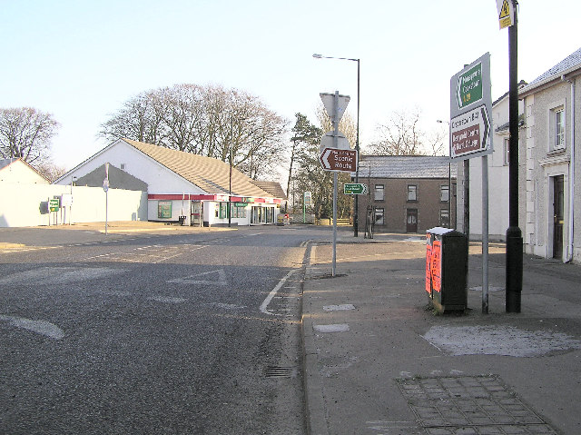
Tobermore
Tobermore (/ˌtʌbərˈmɔːr/), from Irish An Tobar Mór, meaning 'the great well') is a small village in County Londonderry, Northern Ireland named after the townland of Tobermore. The village, which has a predominantly Protestant population, lies 2.5 miles (4.0 km) south-south-west of Maghera and 5.5 miles (8.9 km) north-west of Magherafelt. Tobermore is within the civil parish of Kilcronaghan and is part of Mid-Ulster District. It was also part of the former barony of Loughinsholin.
Tobermore has won the Best Kept Small Village award four times and the Best Kept Large Village award in 1986. In September 2011, Tobermore won the Translink Ulster in Bloom village category for the third year in a row.
Tobermore is named after the townland of Tobermore which is an anglicisation of the Irish words tobar meaning "well" and mór meaning "big/great", thus Tobermore means "big/great well". During the seventeenth century, Tobermore was also known as Tobarmore and Tubbermore, with Tubbermore being the preferred usage of the Masonic Order even to this day.
Tobermore lies on the descending slope of Slieve Gallion. Prominent hills are: Calmore Hill (in Calmore), 268 feet (82 m); and Fortwilliam (in Tobermore), 200 feet (61 m) high.
A large oak tree called the Royal Oak grew near Calmore Castle in Tobermore. Until it was destroyed in a heavy storm, the Royal Oak was said to have been so large that horsemen on horseback could not touch one another with their whips across it. From this vague description, it is conjectured that the Royal Oak was about 10 feet (3.0 m) in diameter or 30 feet (9.1 m) in circumference. Another oak tree that once grew near Tobermore was so tall and straight that it was known as the Fishing Rod. Tradition is that all of the townlands were once covered with magnificent oak trees.
The Moyola River runs from west to east half a mile to the north of Tobermore village, heading through the townlands of Ballynahone Beg and Ballynahone More. In these two townlands lies Ballynahone Bog, one of the largest lowland raised bogs in Northern Ireland.
The earliest reference to the actual settlement of Tobermore is in the mid-18th century of a house built in 1727 that belonged to a James Moore. At some point in the 18th century, the fair that was held at the Gort of the parish church was relocated to Tobermore, which is described as consisting of only Moore's house and a few mud huts. The development and growth of the village can be traced back to this period.
Fortwilliam Hill is situated between the Fortwilliam, Lisnamuck, and Maghera roads in Tobermore, overlooking the River Moyola. Upon it lies Fortwilliam rath, which was built c. 700–1000 AD, and Fortwilliam House, a listed building, built in 1795 by John Stevenson Esq of "The Stevensons the Linen People". The rath was historically known under variations of Donnagrenan, which is most likely derived from the Irish Dún na Grianán, meaning "fort of the eminent place". Its modern name like that of the adjacent house were bestowed upon them by Mr. Jackson, who named it after Fort William, Scotland, which was named in honour of King William III in 1690. A contradictory reason mentioned by John O'Donovan is that the O'Hagans of Ballynascreen claimed it was built and named for Sir William O'Hagan, however, O'Donovan discounts their claims due to other claims they make that are contrary to reality.
Hub AI
Tobermore AI simulator
(@Tobermore_simulator)
Tobermore
Tobermore (/ˌtʌbərˈmɔːr/), from Irish An Tobar Mór, meaning 'the great well') is a small village in County Londonderry, Northern Ireland named after the townland of Tobermore. The village, which has a predominantly Protestant population, lies 2.5 miles (4.0 km) south-south-west of Maghera and 5.5 miles (8.9 km) north-west of Magherafelt. Tobermore is within the civil parish of Kilcronaghan and is part of Mid-Ulster District. It was also part of the former barony of Loughinsholin.
Tobermore has won the Best Kept Small Village award four times and the Best Kept Large Village award in 1986. In September 2011, Tobermore won the Translink Ulster in Bloom village category for the third year in a row.
Tobermore is named after the townland of Tobermore which is an anglicisation of the Irish words tobar meaning "well" and mór meaning "big/great", thus Tobermore means "big/great well". During the seventeenth century, Tobermore was also known as Tobarmore and Tubbermore, with Tubbermore being the preferred usage of the Masonic Order even to this day.
Tobermore lies on the descending slope of Slieve Gallion. Prominent hills are: Calmore Hill (in Calmore), 268 feet (82 m); and Fortwilliam (in Tobermore), 200 feet (61 m) high.
A large oak tree called the Royal Oak grew near Calmore Castle in Tobermore. Until it was destroyed in a heavy storm, the Royal Oak was said to have been so large that horsemen on horseback could not touch one another with their whips across it. From this vague description, it is conjectured that the Royal Oak was about 10 feet (3.0 m) in diameter or 30 feet (9.1 m) in circumference. Another oak tree that once grew near Tobermore was so tall and straight that it was known as the Fishing Rod. Tradition is that all of the townlands were once covered with magnificent oak trees.
The Moyola River runs from west to east half a mile to the north of Tobermore village, heading through the townlands of Ballynahone Beg and Ballynahone More. In these two townlands lies Ballynahone Bog, one of the largest lowland raised bogs in Northern Ireland.
The earliest reference to the actual settlement of Tobermore is in the mid-18th century of a house built in 1727 that belonged to a James Moore. At some point in the 18th century, the fair that was held at the Gort of the parish church was relocated to Tobermore, which is described as consisting of only Moore's house and a few mud huts. The development and growth of the village can be traced back to this period.
Fortwilliam Hill is situated between the Fortwilliam, Lisnamuck, and Maghera roads in Tobermore, overlooking the River Moyola. Upon it lies Fortwilliam rath, which was built c. 700–1000 AD, and Fortwilliam House, a listed building, built in 1795 by John Stevenson Esq of "The Stevensons the Linen People". The rath was historically known under variations of Donnagrenan, which is most likely derived from the Irish Dún na Grianán, meaning "fort of the eminent place". Its modern name like that of the adjacent house were bestowed upon them by Mr. Jackson, who named it after Fort William, Scotland, which was named in honour of King William III in 1690. A contradictory reason mentioned by John O'Donovan is that the O'Hagans of Ballynascreen claimed it was built and named for Sir William O'Hagan, however, O'Donovan discounts their claims due to other claims they make that are contrary to reality.