
Recent from talks
Towra Point Nature Reserve
Knowledge base stats:
Talk channels stats:
Members stats:
Towra Point Nature Reserve
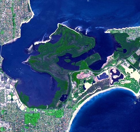
The Towra Point Nature Reserve is a protected nature reserve that is located in Sutherland Shire, Southern Sydney, New South Wales, in eastern Australia. The 603-hectare (1,490-acre) reserve is situated on the southern shores of Botany Bay at Kurnell, within the Sutherland Shire. The reserve is protected under the Ramsar Convention as a wetland of international importance as an important breeding ground for many vulnerable, protected, or endangered species. The Towra Point Aquatic Nature Reserve is located in the surrounding waterways.
Kurnell was inhabited by the Dharawal people, and there are three middens and one relic that still remain today at the Towra Point Nature Reserve.
Captain Cook mapped Botany Bay when he landed in 1770, including Towra Point. Early European colonialists ran horses and cattle on Towra Point, despite the poor condition of the land for such a purpose. In 1827, "Towra Point" and "Towra Bay" were recorded as local names by the surveyor Robert Dixon. Another name known for the area was "Stinkpot Bay". In 1861, Thomas Holt bought Towra Point, and divided it into paddocks for grazing or growing corn. Sheep grazing was particularly disastrous, and many thousands of sheep died of footrot and are buried at Towra Point. In the late 1870s, Thomas Holt began oyster farming at Weeney Bay in Towra Point. In 1935, the Parks and Playgrounds Movement of NSW opposed an application to mine for shell at Towra Point. During World War II, a radar station was established, and a causeway built. In 1946, Towra Point was considered as a location for a second Sydney airport.
In the 1960s, movement began to preserve Towra Point led initially by the President of Sutherland Shire, Arthur Gietzelt, and Tom Uren, the then Federal Minister for Urban Affairs. In 1965 Ian Griffith, state MP for Cronulla, praised the idea, but was met by community backlash. In March 1969, the then Prime Minister, John Gorton ruled out Towra Point as a potential site for a second airport, citing community noise problems. The opening to Botany Bay was dredged in the 1970s to assist shipping, but this refracted the wave patterns in the bay, focusing them on Towra Point, causing erosion. The building of the revetment wall in Port Botany was also thought to contribute to the changed wave patterns. In 1974 and 1975, the waves off Towra were so strong that teens surfed there.
Following lobbying by Ray Thorburn, the reserve was bought by the Government of Australia in 1975, attempting to fulfil obligations to JAMBA, which would come into force in April 1981. This was the first time that the Australian Government had bought land for nature conservation purposes within a state. On 10 September 1979 the oil tanker World Encouragement spilled approximately 95 tonnes (105 short tons) of crude oil into Botany Bay. Mangroves at Quibray Bay, Weeney Bay and Towra Point were impacted – 100 hectares (250 acres) of mangroves were affected, and 4.4 hectares (11 acres) died.
In 1981, another oil spill occurred at the Matraville refinery, causing more damage to the mangroves. In 1982, Towra Point was officially made a nature reserve. In 1983 Towra was suffering from erosion – the Elephant's Trunk, a peninsula of Towra had shrunk to 3 metres wide. The seagrasses were also being eaten by sea-urchins – the population had exploded from 20,000 per hectare in 1979 to 80,000 by 1983. It was declared a Ramsar site (or wetland of international importance) in 1984, at the time meeting Ramsar criteria 1, 2, 3 and 6. In 2009, Towra Point met Ramsar criteria 2, 3, 4 and 8. In 1987, the Towra Point Aquatic Nature Reserve was created, covering 1,400 hectares (3,500 acres) in the waterways surrounding Towra Point. Towra Point Nature Reserve also attempts to meet the Federal government's obligations to CAMBA, which came into force in 1988.[citation needed]
In 1990, the Elephant's Trunk was eroded so much that the tip broke off into an island. By this time, Towra Beach was so eroded that trees that were part of the forest were "tumbling into the water". The Friends of Towra Point volunteer group was founded in February 1997 and they do such activities as bush regeneration, seed collection, vegetation surveys and habitat creation for the little tern. They also coordinate the annual Clean Up Australia Day activities at Towra Point. Habitat creation involves sandbagging the eroding Towra Lagoon, nest tagging, and clearing areas around nests.
In 2003, it was proposed to undertake beach nourishment at Towra Point, involving 60,000 cubic metres of sand. While this had an immediate negative effect on some amphipod species, they had recovered by 2005. In January 2004, 24 little tern were killed after picnickers and a dog accidentally landed on Towra Spit Island. In 2004, a A$1.5 million dredging project was undertaken to cut off Towra Spit Island from the rest of Towra Point to provide a fox-free environment. In around 2007, the La Perouse Aboriginal Community began sending trainees to work in the area for the NSW National Parks & Wildlife Service as part of the "Towra Team", combining bush regeneration work with learning traditional Aboriginal cultural skills.
Hub AI
Towra Point Nature Reserve AI simulator
(@Towra Point Nature Reserve_simulator)
Towra Point Nature Reserve
The Towra Point Nature Reserve is a protected nature reserve that is located in Sutherland Shire, Southern Sydney, New South Wales, in eastern Australia. The 603-hectare (1,490-acre) reserve is situated on the southern shores of Botany Bay at Kurnell, within the Sutherland Shire. The reserve is protected under the Ramsar Convention as a wetland of international importance as an important breeding ground for many vulnerable, protected, or endangered species. The Towra Point Aquatic Nature Reserve is located in the surrounding waterways.
Kurnell was inhabited by the Dharawal people, and there are three middens and one relic that still remain today at the Towra Point Nature Reserve.
Captain Cook mapped Botany Bay when he landed in 1770, including Towra Point. Early European colonialists ran horses and cattle on Towra Point, despite the poor condition of the land for such a purpose. In 1827, "Towra Point" and "Towra Bay" were recorded as local names by the surveyor Robert Dixon. Another name known for the area was "Stinkpot Bay". In 1861, Thomas Holt bought Towra Point, and divided it into paddocks for grazing or growing corn. Sheep grazing was particularly disastrous, and many thousands of sheep died of footrot and are buried at Towra Point. In the late 1870s, Thomas Holt began oyster farming at Weeney Bay in Towra Point. In 1935, the Parks and Playgrounds Movement of NSW opposed an application to mine for shell at Towra Point. During World War II, a radar station was established, and a causeway built. In 1946, Towra Point was considered as a location for a second Sydney airport.
In the 1960s, movement began to preserve Towra Point led initially by the President of Sutherland Shire, Arthur Gietzelt, and Tom Uren, the then Federal Minister for Urban Affairs. In 1965 Ian Griffith, state MP for Cronulla, praised the idea, but was met by community backlash. In March 1969, the then Prime Minister, John Gorton ruled out Towra Point as a potential site for a second airport, citing community noise problems. The opening to Botany Bay was dredged in the 1970s to assist shipping, but this refracted the wave patterns in the bay, focusing them on Towra Point, causing erosion. The building of the revetment wall in Port Botany was also thought to contribute to the changed wave patterns. In 1974 and 1975, the waves off Towra were so strong that teens surfed there.
Following lobbying by Ray Thorburn, the reserve was bought by the Government of Australia in 1975, attempting to fulfil obligations to JAMBA, which would come into force in April 1981. This was the first time that the Australian Government had bought land for nature conservation purposes within a state. On 10 September 1979 the oil tanker World Encouragement spilled approximately 95 tonnes (105 short tons) of crude oil into Botany Bay. Mangroves at Quibray Bay, Weeney Bay and Towra Point were impacted – 100 hectares (250 acres) of mangroves were affected, and 4.4 hectares (11 acres) died.
In 1981, another oil spill occurred at the Matraville refinery, causing more damage to the mangroves. In 1982, Towra Point was officially made a nature reserve. In 1983 Towra was suffering from erosion – the Elephant's Trunk, a peninsula of Towra had shrunk to 3 metres wide. The seagrasses were also being eaten by sea-urchins – the population had exploded from 20,000 per hectare in 1979 to 80,000 by 1983. It was declared a Ramsar site (or wetland of international importance) in 1984, at the time meeting Ramsar criteria 1, 2, 3 and 6. In 2009, Towra Point met Ramsar criteria 2, 3, 4 and 8. In 1987, the Towra Point Aquatic Nature Reserve was created, covering 1,400 hectares (3,500 acres) in the waterways surrounding Towra Point. Towra Point Nature Reserve also attempts to meet the Federal government's obligations to CAMBA, which came into force in 1988.[citation needed]
In 1990, the Elephant's Trunk was eroded so much that the tip broke off into an island. By this time, Towra Beach was so eroded that trees that were part of the forest were "tumbling into the water". The Friends of Towra Point volunteer group was founded in February 1997 and they do such activities as bush regeneration, seed collection, vegetation surveys and habitat creation for the little tern. They also coordinate the annual Clean Up Australia Day activities at Towra Point. Habitat creation involves sandbagging the eroding Towra Lagoon, nest tagging, and clearing areas around nests.
In 2003, it was proposed to undertake beach nourishment at Towra Point, involving 60,000 cubic metres of sand. While this had an immediate negative effect on some amphipod species, they had recovered by 2005. In January 2004, 24 little tern were killed after picnickers and a dog accidentally landed on Towra Spit Island. In 2004, a A$1.5 million dredging project was undertaken to cut off Towra Spit Island from the rest of Towra Point to provide a fox-free environment. In around 2007, the La Perouse Aboriginal Community began sending trainees to work in the area for the NSW National Parks & Wildlife Service as part of the "Towra Team", combining bush regeneration work with learning traditional Aboriginal cultural skills.
Recent media