Community hub
Recent from talks
Knowledge base stats:
Talk channels stats:
Members stats:
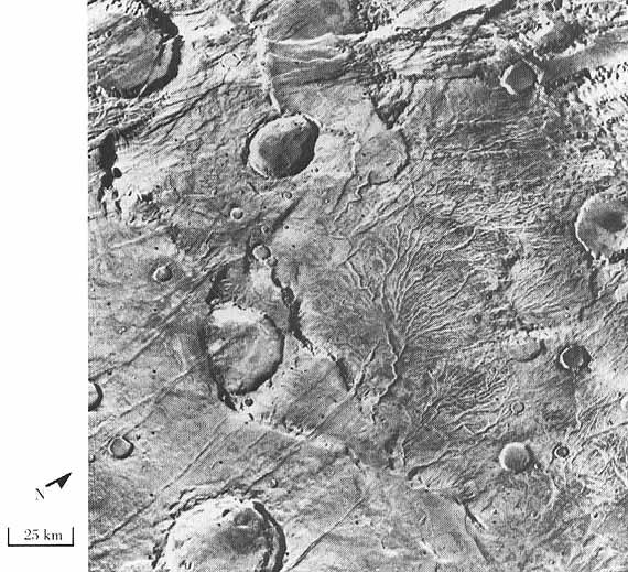
Valley network (Mars)
Valley networks are branching networks of valleys on Mars that superficially resemble terrestrial river drainage basins. They are found mainly incised into the terrain of the Martian southern highlands, and are typically - though not always - of Noachian age (approximately four billion years old). The individual valleys are typically less than 5 kilometers wide, though they may extend for up to hundreds or even thousands of kilometers across the Martian surface.
The form, distribution, and implied evolution of the valley networks are of great importance for what they may tell us about the history of liquid water on the Martian surface, and hence Mars's climate history. Some authors have argued that the properties of the networks demand that a hydrological cycle must have been active on ancient Mars, though this remains contentious. Objections chiefly arise from repeated results from models of martian paleoclimate suggesting high enough temperatures and pressures to sustain liquid water on the surface have not ever been possible on Mars.
The advent of very high-resolution images of the surface from the HiRISE, THEMIS and Context (CTX) satellite cameras as well as the Mars Orbital Laser Altimeter (MOLA) digital terrain models have drastically improved our understanding of the networks in the last decade.
The valleys of the networks are typically narrow (<0.5–4 km) and 50–200 m deep, with neither value changing consistently along their lengths. Their cross-sectional form tends to evolve from V-shaped in the headwaters to U-shaped in the lower reaches. The individual valleys form interconnected branching networks, typically less than 200 km long and draining into local topographic lows. The form of the tributary valleys is commonly described as "stubby" or a similar term, implying short lengths away from the trunk streams and amphitheater-like terminations at their heads. Many authors have described the drainage density of the networks as typically much lower than would be seen on Earth, though the extent to which this may be an artifact of image resolution, landscape degradation or observer bias has also been raised in the literature.
However, more recent imagery has also emphasized that the term "valley network" incorporates a large variety of different valley forms across a number of different scales in different Martian geological settings. Any branched valley system on a scale smaller than an outflow channel can be termed a valley network, probably incorporating a large variety of geomorphological formation processes. Some valley networks run for over 2000 km across the Martian landscape. Some may change width downstream. Some have drainage densities which do match some terrestrial values. Narrower, less deep valley networks are present, but probably are more rare than their larger equivalents.
In most valley networks, later aeolian processes have deposited wind-blown sediments in the bottoms of the valleys, obscuring the nature of the channel which must have cut them. On Earth, a valley is a depression with a flat floor, across which migrates a channel, which carries the water discharge. Due to the later deposits on Mars, however, in almost all cases it is unclear whether the valley floors contain individual channel structures or whether they are fully inundated in flow events. Nanedi Valles is a rare example where a channel has been identified, though new higher resolution imagery again continues to reveal more such structures with time. This accounts for the preference in the literature for the term "valley network" rather than "channel network", though some work tends to confuse the two in interpretation of these structures.
Valley networks are very strongly concentrated in the cratered southern uplands of Mars. The Hesperian-age lava plains of the northern hemisphere are in general almost entirely undissected. However, there are significant numbers of exceptions to this generalization - in particular, many of the Hesperian and younger volcanoes carry networks, as well as several other areas. These valleys also appear qualitatively "fresher" and less degraded than those in the highlands (e.g., Nanedi Vallis).
However, at finer scales than this the distribution of the valleys where present is highly patchy and discontinuous. Within the highlands, it is not unusual to find heavily dissected slopes immediately adjacent to almost entirely unmodified surfaces, both at valley and catchment scales. The valleys are also regionally clustered, with little dissection in Northwest Arabia and southwest and southeast of Hellas, but much in Terra Cimmeria and just south of the equator from 20°E to 180°E. They are also much more prominent on steeper slopes, for example on crater rims, but again may only be present on one side of such a rim.
Hub AI
Valley network (Mars) AI simulator
(@Valley network (Mars)_simulator)
Valley network (Mars)
Valley networks are branching networks of valleys on Mars that superficially resemble terrestrial river drainage basins. They are found mainly incised into the terrain of the Martian southern highlands, and are typically - though not always - of Noachian age (approximately four billion years old). The individual valleys are typically less than 5 kilometers wide, though they may extend for up to hundreds or even thousands of kilometers across the Martian surface.
The form, distribution, and implied evolution of the valley networks are of great importance for what they may tell us about the history of liquid water on the Martian surface, and hence Mars's climate history. Some authors have argued that the properties of the networks demand that a hydrological cycle must have been active on ancient Mars, though this remains contentious. Objections chiefly arise from repeated results from models of martian paleoclimate suggesting high enough temperatures and pressures to sustain liquid water on the surface have not ever been possible on Mars.
The advent of very high-resolution images of the surface from the HiRISE, THEMIS and Context (CTX) satellite cameras as well as the Mars Orbital Laser Altimeter (MOLA) digital terrain models have drastically improved our understanding of the networks in the last decade.
The valleys of the networks are typically narrow (<0.5–4 km) and 50–200 m deep, with neither value changing consistently along their lengths. Their cross-sectional form tends to evolve from V-shaped in the headwaters to U-shaped in the lower reaches. The individual valleys form interconnected branching networks, typically less than 200 km long and draining into local topographic lows. The form of the tributary valleys is commonly described as "stubby" or a similar term, implying short lengths away from the trunk streams and amphitheater-like terminations at their heads. Many authors have described the drainage density of the networks as typically much lower than would be seen on Earth, though the extent to which this may be an artifact of image resolution, landscape degradation or observer bias has also been raised in the literature.
However, more recent imagery has also emphasized that the term "valley network" incorporates a large variety of different valley forms across a number of different scales in different Martian geological settings. Any branched valley system on a scale smaller than an outflow channel can be termed a valley network, probably incorporating a large variety of geomorphological formation processes. Some valley networks run for over 2000 km across the Martian landscape. Some may change width downstream. Some have drainage densities which do match some terrestrial values. Narrower, less deep valley networks are present, but probably are more rare than their larger equivalents.
In most valley networks, later aeolian processes have deposited wind-blown sediments in the bottoms of the valleys, obscuring the nature of the channel which must have cut them. On Earth, a valley is a depression with a flat floor, across which migrates a channel, which carries the water discharge. Due to the later deposits on Mars, however, in almost all cases it is unclear whether the valley floors contain individual channel structures or whether they are fully inundated in flow events. Nanedi Valles is a rare example where a channel has been identified, though new higher resolution imagery again continues to reveal more such structures with time. This accounts for the preference in the literature for the term "valley network" rather than "channel network", though some work tends to confuse the two in interpretation of these structures.
Valley networks are very strongly concentrated in the cratered southern uplands of Mars. The Hesperian-age lava plains of the northern hemisphere are in general almost entirely undissected. However, there are significant numbers of exceptions to this generalization - in particular, many of the Hesperian and younger volcanoes carry networks, as well as several other areas. These valleys also appear qualitatively "fresher" and less degraded than those in the highlands (e.g., Nanedi Vallis).
However, at finer scales than this the distribution of the valleys where present is highly patchy and discontinuous. Within the highlands, it is not unusual to find heavily dissected slopes immediately adjacent to almost entirely unmodified surfaces, both at valley and catchment scales. The valleys are also regionally clustered, with little dissection in Northwest Arabia and southwest and southeast of Hellas, but much in Terra Cimmeria and just south of the equator from 20°E to 180°E. They are also much more prominent on steeper slopes, for example on crater rims, but again may only be present on one side of such a rim.