Recent from talks
Nothing was collected or created yet.
Valley
View on WikipediaThis article needs additional citations for verification. (May 2013) |


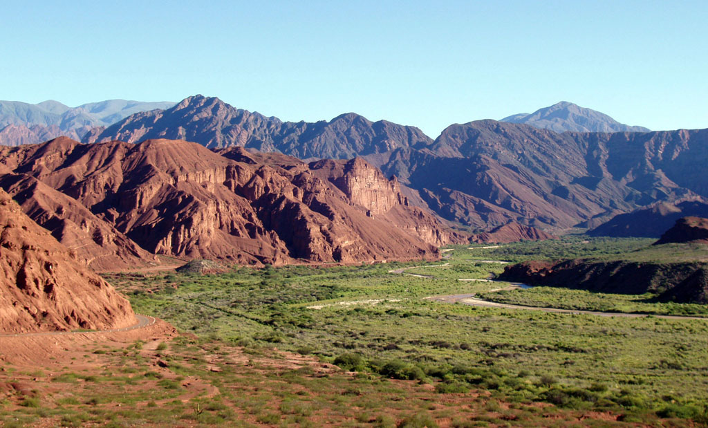
A valley is an elongated low area often running between hills or mountains and typically containing a river or stream running from one end to the other. Most valleys are formed by erosion of the land surface by rivers or streams over a very long period. Some valleys are formed through erosion by glacial ice. These glaciers may remain present in valleys in high mountains or polar areas.
At lower latitudes and altitudes, these glacially formed valleys may have been created or enlarged during ice ages but now are ice-free and occupied by streams or rivers. In desert areas, valleys may be entirely dry or carry a watercourse only rarely. In areas of limestone bedrock, dry valleys may also result from drainage now taking place underground rather than at the surface. Rift valleys arise principally from earth movements, rather than erosion. Many different types of valleys are described by geographers, using terms that may be global in use or else applied only locally.
Formation of valleys
[edit]Valleys may arise through several different processes. Most commonly, they arise from erosion over long periods by moving water and are known as river valleys. Typically small valleys containing streams feed into larger valleys which in turn feed into larger valleys again, eventually reaching the ocean or perhaps an internal drainage basin. In polar areas and at high altitudes, valleys may be eroded by glaciers; these typically have a U-shaped profile in cross-section, in contrast to river valleys, which tend to have a V-shaped profile. Other valleys may arise principally through tectonic processes such as rifting. All three processes can contribute to the development of a valley over geological time. The flat (or relatively flat) portion of a valley between its sides is referred to as the valley floor. The valley floor is typically formed by river sediments and may have fluvial terraces.
River valleys
[edit]

The development of a river valley is affected by the character of the bedrock over which the river or stream flows, the elevational difference between its top and bottom, and indeed the climate. Typically the flow will increase downstream and the gradient will decrease. In the upper valley, the stream will most effectively erode its bed through corrasion to produce a steep-sided V-shaped valley. The presence of more resistant rock bands, of geological faults, fractures, and folds may determine the course of the stream and result in a twisting course with interlocking spurs.
In the middle valley, as numerous streams have coalesced, the valley is typically wider, the flow slower and both erosion and deposition may take place. More lateral erosion takes place in the middle section of a river's course, as strong currents on the outside of its curve erode the bank. Conversely, deposition may take place on the inside of curves where the current is much slacker, the process leading to the river assuming a meandering character. In the lower valley, gradients are lowest, meanders may be much broader and a broader floodplain may result. Deposition dominates over erosion.[1][2] A typical river basin or drainage basin will incorporate each of these different types of valleys.
Some sections of a stream or river valleys may have vertically incised their course to such an extent that the valley they occupy is best described as a gorge, ravine, or canyon. Rapid down-cutting may result from localized uplift of the land surface or rejuvenation of the watercourse as a result for example of a reduction in the base level to which the river is eroded, e.g. lowered global sea level during an ice age. Such rejuvenation may also result in the production of river terraces.[3]
Glacial valleys
[edit]

There are various forms of valleys associated with glaciation. True glacial valleys are those that have been cut by a glacier which may or may not still occupy the valley at the present day. Such valleys may also be known as glacial troughs. They typically have a U-shaped cross-section and are characteristic landforms of mountain areas where glaciation has occurred or continues to take place.[4]
The uppermost part of a glacial valley frequently consists of one or more 'armchair-shaped' hollows, or 'cirques', excavated by the rotational movement downslope of a cirque glacier. During glacial periods, for example, the Pleistocene ice ages, it is in these locations that glaciers initially form and then, as the ice age proceeds, extend downhill through valleys that have previously been shaped by water rather than ice. Abrasion by rock material embedded within the moving glacial ice causes the widening and deepening of the valley to produce the characteristic U or trough shape with relatively steep, even vertical sides and a relatively flat bottom.
Interlocking spurs associated with the development of river valleys are preferentially eroded to produce truncated spurs, typical of glaciated mountain landscapes. The upper end of the trough below the ice-contributing cirques may be a trough-end. Valley steps (or 'rock steps') can result from differing erosion rates due to both the nature of the bedrock (hardness and jointing for example) and the power of the moving ice. In places, a rock basin may be excavated which may later be filled with water to form a ribbon lake or else by sediments. Such features are found in coastal areas as fjords. The shape of the valley which results from all of these influences may only become visible upon the recession of the glacier that forms it.[5] A river or stream may remain in the valley; if it is smaller than one would expect given the size of its valley, it can be considered an example of a misfit stream.

Other interesting glacially carved valleys include:
- Yosemite Valley (United States)
- Side valleys of the Austrian river Salzach for their parallel directions and hanging mouths.
- That of the St. Mary River in Glacier National Park in Montana, United States.
Tunnel
[edit]A tunnel valley is a large, long, U-shaped valley originally cut under the glacial ice near the margin of continental ice sheets such as that now covering Antarctica and formerly covering portions of all continents during past glacial ages.[6] Such valleys can be up to 100 km (62 mi) long, 4 km (2.5 mi) wide, and 400 m (1,300 ft) deep (its depth may vary along its length). Tunnel valleys were formed by subglacial water erosion. They once served as subglacial drainage pathways carrying large volumes of meltwater. Their cross-sections exhibit steep-sided flanks similar to fjord walls, and their flat bottoms are typical of subglacial glacial erosion.
Meltwater
[edit]In northern Central Europe, the Scandinavian ice sheet during the various ice ages advanced slightly uphill against the lie of the land. As a result, its meltwaters flowed parallel to the ice margin to reach the North Sea basin, forming huge, flat valleys known as Urstromtäler. Unlike the other forms of glacial valleys, these were formed by glacial meltwaters.
Transition forms and shoulders
[edit]
Depending on the topography, the rock types, and the climate, a variety of transitional forms between V-, U- and plain[clarification needed] valleys can form. The floor or bottom of these valleys can be broad or narrow, but all valleys have a shoulder. The broader a mountain valley, the lower its shoulders are located in most cases. An important exception is canyons where the shoulder almost is near the top of the valley's slope. In the Alps – e.g. the Tyrolean Inn valley – the shoulders are quite low (100–200 meters above the bottom). Many villages are located here (esp. on the sunny side) because the climate is very mild: even in winter when the valley's floor is filled with fog, these villages are in sunshine.
In some stress-tectonic regions of the Rocky Mountains or the Alps (e.g. Salzburg), the side valleys are parallel to each other, and are hanging. Smaller streams flow into rivers as deep canyons or waterfalls.
Hanging tributary
[edit]
A hanging valley is a tributary valley that is higher than the main valley. They are most commonly associated with U-shaped valleys, where a tributary glacier flows into a glacier of larger volume. The main glacier erodes a deep U-shaped valley with nearly vertical sides, while the tributary glacier, with a smaller volume of ice, makes a shallower U-shaped valley. Since the surfaces of the glaciers were originally at the same elevation, the shallower valley appears to be 'hanging' above the main valley. Often, waterfalls form at or near the outlet of the upper valley.[7]
Hanging valleys also occur in fjord systems underwater. The branches of Sognefjord are much shallower than the main fjord. The mouth of Fjærlandsfjord is about 400 meters (1,300 ft) deep while the main fjord nearby is 1,200 meters (3,900 ft) deep. The mouth of Ikjefjord is only 50 meters (160 ft) deep while the main fjord is around 1,300 meters (4,300 ft) at the same point.[8]
Glaciated terrain is not the only site of hanging streams and valleys. Hanging valleys are also simply the product of varying rates of erosion of the main valley and the tributary valleys. The varying rates of erosion are associated with the composition of the adjacent rocks in the different valley locations. The tributary valleys are eroded and deepened by glaciers or erosion at a slower rate than that of the main valley floor; thus the difference in the two valleys' depth increases over time. The tributary valley, composed of more resistant rock, then hangs over the main valley.[9]
Trough-shaped
[edit]Trough-shaped valleys also form in regions of heavy topographic denudation. By contrast with glacial U-shaped valleys, there is less downward and sideways erosion. The severe downslope denudation results in gently sloping valley sides; their transition to the actual valley bottom is unclear. Trough-shaped valleys occur mainly in periglacial regions and in tropical regions of variable wetness. Both climates are dominated by heavy denudation.[10]
Box
[edit]Box valleys have wide, relatively level floors and steep sides. They are common in periglacial areas and occur in mid-latitudes, but also occur in tropical and arid regions.[11]
Rift
[edit]Rift valleys, such as the Albertine Rift and Gregory Rift are formed by the expansion of the Earth's crust due to tectonic activity beneath the Earth's surface.
Terms for valleys
[edit]There are many terms used for different sorts of valleys. They include:
- Cove: A small valley, closed at one or both ends, in the central or southern Appalachian Mountains which sometimes results from the erosion of a geologic window.
- Dell: A small, secluded, and often wooded valley.
- Dry valley: A valley not created by sustained surface water flow.
- Erosional valley: A valley formed by erosion.
- Hollow: A term used regionally for a small valley surrounded by mountains or ridges. In Ireland, New England, Appalachia, and the Ozarks of Arkansas and Missouri, a hollow is a small valley or dry stream bed; often called a holler.
- Longitudinal valley: An elongated valley found between two nearly-parallel mountain chains.
- Steephead valley: A deep, narrow, flat-bottomed valley with an abrupt ending.
- Strike valley: A valley typically developed parallel to a cuesta from more readily eroded strata.
- Structural valley: A valley formed by geologic events such as drop faults or the rise of highlands.[12]
Similar geographical features such as gullies, chines, and kloofs, are not usually referred to as valleys.
British regional terms for valleys
[edit]
The terms corrie, glen, and strath are all Anglicisations of Gaelic terms and are commonly encountered in place-names in Scotland and other areas where Gaelic was once widespread. Strath signifies a wide valley between hills, the floor of which is either level or slopes gently.[13] A glen is a river valley which is steeper and narrower than a strath.[14] A corrie is a basin-shaped hollow in a mountain.[15] Each of these terms also occurs in parts of the world formerly colonized by Britain. Corrie is used more widely by geographers as a synonym for (glacial) cirque, as is the word cwm borrowed from Welsh.[16]
The word dale occurs widely in place names in the north of England and, to a lesser extent, in southern Scotland. As a generic name for a type of valley, the term typically refers to a wide valley, though there are many much smaller stream valleys within the Yorkshire Dales which are named "(specific name) Dale".[17] Clough is a word in common use in northern England for a narrow valley with steep sides.[18] Gill is used to describe a ravine containing a mountain stream in Cumbria and the Pennines.[19] The term combe (also encountered as coombe) is widespread in southern England and describes a short valley set into a hillside.[20] Other terms for small valleys such as hope, dean, slade, slack and bottom are commonly encountered in place-names in various parts of England but are no longer in general use as synonyms for valley.
The term vale is used in England and Wales to describe a wide river valley, usually with a particularly wide flood plain or flat valley bottom. In Southern England, vales commonly occur between the outcrops of different relatively erosion-resistant rock formations, where less resistant rock, often claystone has been eroded. An example is the Vale of White Horse in Oxfordshire.
Human settlement
[edit]Some of the first human complex societies originated in river valleys, such as that of the Nile, Tigris-Euphrates, Indus, Ganges, Yangtze, Yellow River, Mississippi, and arguably the Amazon. In prehistory, the rivers were used as a source of fresh water and food (fish and game), as well as a place to wash and a sewer. The proximity of water moderated temperature extremes and provided a source for irrigation, stimulating the development of agriculture. Most of the first civilizations developed from these river valley communities. Siting of settlements within valleys is influenced by many factors, including the need to avoid flooding and the location of river crossing points.
Notable examples
[edit]
Africa
[edit]- Albertine Rift
- East African Rift
- Ethiopian Rift Valley
- Great Rift Valley
- Nile Valley (Egypt/Sudan/Ethiopia/Uganda)
- Nugaal Valley (Somalia)
- Umba Valley (Tanzania)
- Valley of the Kings (Egypt)
Asia
[edit]
- List of valleys in India
- List of valleys in Pakistan
- Beqaa Valley (Lebanon)
- Dang Valley (Western Nepal)
- Emin Valley (Kazakhstan)
- Ihlara, Turkey
- Jordan Rift Valley (Jordan - Israel)
- Jordan Valley
- Kathmandu (Nepal)
- Klang Valley (Malaysia)
- Mahaweli (Sri Lanka)
- Panjshir Valley (Afghanistan)
- Valleys of China
Oceania
[edit]
- Barossa Valley (Australia)
- Bulolo Valley (Papua New Guinea)
- Cagayan Valley (Philippines)
- Capertee Valley (Australia)
- Hunter Valley (Australia)
- Hutt Valley (New Zealand)
- Kangaroo Valley (Australia)
- Markham Valley (Papua New Guinea)
- Strath Taieri (New Zealand)
- Swan Valley (Australia)
Europe
[edit]- Bergensdalen (Vestland, Norway)
- Dalen, Telemark (Telemark, Norway)
- Danube Valley (Eastern Europe)
- Evrotas Valley, Sparta (Greece)
- Glen Coe (Scotland, United Kingdom)
- Great Glen (Scotland, United Kingdom)
- Gudbrandsdalen (Oppland, Norway)
- Hallingdalen (Buskerud, Norway)
- Heddal (Telemark, Norway)
- Iron Gates (Romania/Serbia)
- Lauterbrunnen Valley (Bern, Switzerland)
- Loire Valley with its famous castles (France)
- Midt-Telemark (Telemark, Norway)
- Nant Ffrancon (Wales, United Kingdom)
- Numedalen (Buskerud, Norway)
- Østerdalen (Hedmark, Norway)
- Po Valley, (Italy)
- Rhone Valley from the Matterhorn to Grenoble and Lyon (France)
- Romsdalen (Møre Og Romsdal, Norway)
- Setesdal (Agder, Norway)
- South Wales Valleys (Wales, United Kingdom)
- Upper Rhine Valley or Upper Rhine Plain, an old graben system. (France and Germany)
- Vestfjorddalen (Norway)
North America
[edit]
- Central Valley (California)
- Coachella Valley (California)
- Cumberland Valley (Maryland/Pennsylvania)
- Cuyahoga Valley (Ohio)
- Death Valley (California)
- Fraser Canyon (British Columbia)
- Fraser Valley (British Columbia)
- Grand Canyon (Arizona, United States)
- Hell's Gate (British Columbia)
- Hudson Valley (New York)
- Imperial Valley (California)
- Las Vegas Valley (Nevada)
- Missouri River Valley (Missouri)
- Monument Valley (Arizona, Utah)
- Napa Valley (California)
- Okanagan Valley (British Columbia)
- Ottawa Valley (Ontario/Quebec)
- Palo Duro Canyon (Texas)
- Valley of the Sun (Arizona)
- Rio Grande Valley (Texas)
- Rocky Mountain Trench (British Columbia/Montana)
- Saint Lawrence Valley (Ontario/Quebec/New York)
- Salt Lake Valley (Utah)
- San Fernando Valley (California)
- Shenandoah Valley (Virginia/West Virginia)
- Sonoma Valley (California)
- Toluca Valley (Mexico)
- Valley of the Gods (Utah)
- Valley of Mexico (Mexico)
- Willamette Valley (Oregon)
- Yosemite Valley (California)
South America
[edit]- Aburra Valley (Colombia)
- Calchaquí Valleys (Argentina)
- Cauca Valley (Colombia)
- Ischigualasto Valley of the Moon (Argentina)
- Paraíba Valley (Brazil)
Antarctica
[edit]Extraterrestrial valleys
[edit]Numerous elongate depressions have been identified on the surface of Mars, Venus, the Moon, and other planets and their satellites and are known as valles (singular: 'vallis'). Deeper valleys with steeper sides (akin to canyons) on certain of these bodies are known as chasmata (singular: 'chasma'). Long narrow depressions are referred to as fossae (singular: 'fossa').[21] These are the Latin terms for 'valley, 'gorge' and 'ditch' respectively. The German term 'rille' or Latin term 'rima' (signifying 'cleft') is used for certain other elongate depressions on the Moon.[22]
See also:
See also
[edit]- Canyon – Deep chasm between cliffs
- Grass valley – Meadow within a forested and relatively small drainage basin
- Gully – Landform created by running water and/or mass movement eroding sharply into soil
- Paleovalley – Inactive river or stream channel that has been filled or buried
- Stream channel – Narrow body of water
References
[edit]- ^ Monkhouse, F.J. (1971). Principles of Physical Geography (Seventh ed.). London: University of London Press Ltd. pp. 152–157. ISBN 0340090227.
- ^ Morisawa, Marie (1968). Rhodes W. Fairbridge (ed.). Classification of Rivers. New York: Reinhold Book Corporation. pp. 956–957. OCLC 2968.
- ^ Monkhouse, F.J. (1971). Principles of Physical Geography (Seventh ed.). London: University of London Press Ltd. pp. 161–164. ISBN 0340090227.
- ^ "Vale of Eden". Britannica. Retrieved 20 December 2020.
- ^ Monkhouse, F.J. (1971). Principles of Physical Geography (Seventh ed.). London: University of London Press Ltd. pp. 230–234. ISBN 0340090227.
- ^ Jørgensen, Flemming; Peter B.E. Sandersen (June 2006). "Buried and open tunnel valleys in Denmark—erosion beneath multiple ice sheets". Quaternary Science Reviews. 25 (11–12): 1339–1363. Bibcode:2006QSRv...25.1339J. doi:10.1016/j.quascirev.2005.11.006.
- ^ "Glossary of Glacier Terminology". U.S. Geological Survey. May 28, 2004. Retrieved 2007-05-24.
- ^ Nesje, A., & Whillans, I. M. (1994). Erosion of Sognefjord, Norway. Geomorphology, 9(1), 33-45.
- ^ "Illustrated Glossary of Alpine Glacial Landforms - Hanging Valley". .uwsp.edu. Archived from the original on 2011-06-09. Retrieved 2011-10-03.
- ^ Rowley, Taylor; Giardino, John R.; Granados-Aguilar, Raquel; Vitek, John D. (2015-01-01), Giardino, John R.; Houser, Chris (eds.), Chapter 13 - Periglacial Processes and Landforms in the Critical Zone, Developments in Earth Surface Processes, vol. 19, Elsevier, pp. 397–447, doi:10.1016/B978-0-444-63369-9.00013-6, ISBN 978-0-444-63369-9, retrieved 2023-10-19
- ^ Goudie, Andrew, ed. (2004). Encyclopedia of Geomorphology. Psychology Press. p. 98. ISBN 9780415327381.
- ^ "Early History, Santa Clara County". National Park Service. Archived from the original on July 3, 2007. Retrieved January 16, 2015.
Santa Clara Valley is a structural valley, created by mountain building, as opposed to an erosional valley, or one which has undergone the wearing away of the earth's surface by natural agents.
- ^ Ross, David (2001). Scottish Place-names (First ed.). Edinburgh: Birlinn. p. 203. ISBN 1841581739.
- ^ Ross, David (2001). Scottish Place-names (First ed.). Edinburgh: Birlinn. p. 99. ISBN 1841581739.
- ^ Ross, David (2001). Scottish Place-names (First ed.). Edinburgh: Birlinn. p. 53. ISBN 1841581739.
- ^ Whitten, D.G.A.; Brooks, J.R.V. (1972). Dictionary of Geology (First ed.). London: Penguin. p. 83. ISBN 0140510494.
- ^ "Bing maps". Microsoft Bing. Retrieved 20 December 2020.
- ^ Gelling, Margaret (1984). Place-names in the Landscape: the Geographical roots of Britain's place-names (First ed.). London: J M Dent. p. 88. ISBN 0460860860.
- ^ Gelling, Margaret (1984). Place-names in the Landscape: the Geographical roots of Britain's place-names (First ed.). London: J M Dent. p. 99. ISBN 0460860860.
- ^ "Combe". Merriam–Webster's Dictionary. Merriam–Webster. 2011.
- ^ "Gazetteer of Planetary Nomenclature, feature types". International Astronomical Union. Retrieved 20 December 2020.
- ^ "Gazetteer of Planetary Nomenclature, Welcome". International Astronomical Union. Retrieved 20 December 2020.
External links
[edit]- Valley Development Four Stages of Valley Development
- NPS.gov, University of Wisconsin
- UWSP.edu, Glossary of Alpine Glacial Landforms
- "BGU.ac.il" (PDF)., SAR interferometry (analysis of valley forms in Fig.2 and 6)
- Valleys.com, Valleys of the World
- Valley definitions, YourDictionary
Extraterrestrial valleys
[edit]- ESA image: Vallis Alpes, bisecting the Lunar Alps
- Valles Marineris and Ophir Chasma, bilingual website (English and German)
Valley
View on GrokipediaDefinition and Characteristics
Geological Definition
A valley is an elongated, low-lying depression in the Earth's surface, typically situated between higher elevations such as hills or mountains, and often occupied by a watercourse running along its floor. This landform represents a fundamental feature of geomorphology, distinguished by its linear extent and bounded flanks. Valleys form primarily through erosional processes that carve down surrounding terrain or via tectonic forces that create structural depressions, with the majority exhibiting a combination of these influences over geological timescales.[9][6][10] Key characteristics of valleys include their pronounced elongation, where length far exceeds both width and depth, often by orders of magnitude, enabling them to serve as conduits for drainage systems. The longitudinal profile traces the valley's gradient from an upstream source—typically steeper and narrower—to a downstream mouth, where it broadens and flattens, forming a generally concave curve that reflects progressive sediment transport and deposition. In contrast, the cross-sectional profile displays variability based on formative agents, such as steep, narrow incisions or broader floors, but always emphasizes the relative shallowness compared to overall length. These attributes underscore valleys as dynamic expressions of landscape evolution, integrating surface and subsurface processes.[4] The geological recognition of valleys as erosional features traces back to the early 19th century, when Scottish natural philosopher John Playfair articulated the principle that rivers actively incise their own channels, linking valley morphology directly to fluvial action rather than solely to depositional or catastrophic origins. In his seminal 1802 work, Illustrations of the Huttonian Theory of the Earth, Playfair provided observational evidence from British landscapes, establishing erosion as a primary mechanism and influencing subsequent uniformitarian views in geomorphology.[11] This foundational insight shifted understanding from static to process-driven interpretations of valleys. Measurement of valleys focuses on essential parameters to quantify their scale and form: depth, measured as the vertical distance from the valley floor to the surrounding rim; width, the horizontal span across the depression at the rim or floor level; and aspect ratio, typically the ratio of width to depth, which highlights morphological differences—for instance, low ratios (e.g., <1:1) in narrow, steep-walled valleys versus higher ratios (e.g., >10:1) in broader, flat-bottomed ones. These metrics provide context for assessing landscape stability and erosional history without exhaustive detail, prioritizing ratios that capture overall proportionality.[10][12]Morphological Features
Valleys display distinctive cross-sectional shapes that reflect the dominant erosional agents involved. Fluvial valleys often exhibit V-shaped profiles characterized by steep side slopes converging to a narrow floor, resulting from predominant vertical incision by running water. In contrast, glacial valleys typically feature U-shaped cross-sections with broad, rounded bottoms and near-vertical walls, formed through extensive lateral scouring and basal abrasion by ice masses. Mature or widened valleys, particularly in humid environments, may develop flat floors as ongoing erosion broadens the base while side slopes retreat.[13][14][15] Longitudinal profiles of valleys generally follow a concave-upward trajectory, with steep gradients and high relief near the source areas transitioning to gentler slopes and lower gradients downstream as the valley approaches base level. This profile arises from the cumulative effects of headward erosion and downstream sediment deposition. In alluvial settings, the lower reaches may include sinuous meanders, where the valley floor broadens to accommodate lateral channel migration and floodplain development.[16][17][18] Associated morphological features enhance the structural complexity of valleys. At valley mouths, alluvial fans commonly form as sediment-laden streams debouch onto adjacent plains, creating cone-shaped depositional aprons. Terraces appear as stepped benches along valley sides, representing former floodplain levels exposed by subsequent incision. Shoulders or lateral benches may also occur, marking zones of reduced erosion where resistant rock layers or changes in slope promote sediment accumulation. These features collectively indicate phases of aggradation and degradation within the valley system.[18][19] Valleys vary widely in scale, ranging from narrow gorges less than 1 km in width and depth to expansive basins exceeding 10 km across, with overall dimensions relative to surrounding uplands determined by the intensity and duration of erosional activity. Such variations underscore the role of local topography in defining valley relief. Morphology is further modulated by influencing factors including rock type, which dictates resistance to erosion; climate, which controls precipitation and vegetation cover affecting runoff and weathering; and base level, which sets the lower limit of downcutting and influences profile concavity. These elements interact to produce the diverse physical attributes observed in valley landscapes.[20][15]Formation Processes
Fluvial Processes
Fluvial processes involve the erosional, transportational, and depositional actions of rivers and streams, which primarily shape valleys through the continuous interaction of flowing water with the underlying bedrock and sediment. These processes dominate in non-glaciated landscapes, where rivers incise downward and laterally to form characteristic landforms. Erosion begins with the river's ability to pick up and move material, facilitated by water's kinetic energy, which varies with discharge, velocity, and sediment load.[21] Key erosion mechanisms include hydraulic action, where the forceful impact and pressure fluctuations of turbulent water dislodge particles from the riverbed and banks; abrasion (or corrasion), in which entrained sediment acts like sandpaper to scour the channel; corrosion (or solution), the chemical dissolution of soluble rocks such as limestone by slightly acidic river water; and attrition, the breakdown of transported particles through collisions with each other or the bed. During transportation, rivers carry sediment as bedload—larger particles that roll, slide, or saltate along the bottom—or suspended load, finer particles held aloft in the water column. These mechanisms are most effective in the upper reaches of rivers, where high gradients accelerate flow and enable vertical incision, progressively deepening valleys.[22][23] Valley development progresses through stages outlined in the geographical cycle of erosion, as proposed by William Morris Davis. In the youthful stage, steep gradients and high energy promote rapid downcutting, resulting in narrow, steep-sided V-shaped valleys with minimal floodplain development. As the river approaches base level—the lowest point to which it can erode, often sea level—the gradient lessens, shifting focus to lateral erosion in the mature stage, where the valley widens, meanders form through undercutting of outer banks, and floodplains emerge from sediment deposition during overflows. In the old stage, further erosion is minimal, yielding broad, flat-bottomed valleys with extensive meandering channels and thick alluvial fills. Changes in base level, such as a fall due to sea-level lowering or tectonic uplift, trigger rejuvenation, renewing incision and creating stepped valley profiles with knickpoints where the river's gradient steepens abruptly.[24] Tributary interactions further modify fluvial valleys, as smaller streams entering the main channel often deposit alluvial fans at junctions due to sudden velocity reduction, contributing to floodplain aggradation. Lateral erosion along the main river promotes meander migration, where concave banks erode while convex banks accrete sediment, gradually widening the valley floor. Climate exerts significant control, with higher precipitation in humid regions increasing river discharge and erosional efficiency, thereby accelerating valley incision and relief reduction compared to arid areas where sporadic high-magnitude flows dominate but overall rates are lower.[25][26]Glacial Processes
Glacial erosion primarily occurs through two mechanisms: plucking, also known as quarrying, where the glacier freezes to bedrock irregularities and lifts or tears away chunks of rock as it moves, and abrasion, where debris embedded in the basal ice scrapes and polishes the underlying bedrock like sandpaper.[27][28] These processes transform pre-existing V-shaped fluvial valleys into characteristic U-shaped glacial valleys by widening the sides through lateral erosion and deepening the floor through vertical erosion, resulting in steep walls and flat bottoms.[29][30] Overdeepening often accompanies this, where erosion extends below the surrounding base level, creating elongated troughs that can exceed 100 meters in depth and serve as sediment traps during deglaciation.[31][30] Among the subtypes of glacially influenced valleys, tunnel valleys form as subglacial channels incised by high-pressure meltwater flows, often triggered by sudden bursts from subglacial reservoirs, resulting in narrow, sinuous incisions up to several kilometers long and tens of meters deep.[32][33] Meltwater valleys, in contrast, arise from surface meltwater streams or catastrophic jökulhlaups—outburst floods from ice-dammed lakes—that erode broad channels during rapid discharge events, with peak flows capable of excavating meters of sediment and bedrock in hours.[34][35] At the head of many glacial valleys, cirques develop as amphitheater-like basins through rotational sliding, where ice at the glacier's upper margin rotates and slides over a frozen bed, plucking and abrading the headwall to form steep, bowl-shaped depressions often 100-500 meters deep.[36] Following deglaciation, valleys undergo post-glacial adjustments, including isostatic rebound where the Earth's crust rises at rates of 1-10 mm per year to compensate for the removed ice load, potentially steepening valley gradients and enhancing fluvial incision.[30] Paraglacial sedimentation then fills these overdeepened troughs with debris from unstable slopes, such as rockfalls and landslides, depositing up to hundreds of meters of sediment that can partially infill the valley floor over millennia.[37] Diagnostic evidence of glacial processes in valleys includes roche moutonnées—asymmetrical, smoothed bedrock knobs with a gentle up-ice slope and steeper down-ice face from plucking—glacial striations as linear scratches on bedrock indicating ice flow direction, and erratics as large boulders transported far from their source bedrock and deposited by melting ice.[39][40][41]Tectonic and Other Processes
Tectonic processes play a crucial role in valley formation through crustal movements that involve faulting and uplift, often independent of surface erosion. In extensional settings, divergent plate boundaries lead to normal faulting, where blocks of the Earth's crust drop down along faults to create rift valleys, also known as grabens, flanked by elevated horst blocks.[42] These structures form when the lithosphere stretches and thins, allowing the central block to subside and produce elongated depressions that can span hundreds of kilometers.[43] In compressional environments, such as convergent plate margins, reverse faulting and block faulting uplift crustal blocks while adjacent areas subside, forming fault-block valleys bounded by steep escarpments.[44][45] Karst processes contribute to valley development through the chemical dissolution of soluble bedrock, primarily limestone, dolomite, and gypsum, resulting in subsurface drainage and surface collapse features. Sinkhole valleys, or dolines, emerge as closed depressions where overlying soil and rock dissolve and collapse into underlying voids, often measuring tens to hundreds of meters in diameter and depth.[46] Larger karst valleys, such as poljes, form in broader depressions where dissolution enlarges underground conduits, leading to surface lowering and flat-floored basins that can extend several kilometers. These features are prevalent in humid to semi-arid regions with carbonate rocks, where groundwater acidity accelerates the removal of material without significant mechanical erosion.[47] Volcanic activity can produce valley-like depressions through caldera formation and lava infilling, while aeolian processes carve wind-eroded hollows that mimic valley morphology. Calderas arise from the collapse of volcanic structures following massive eruptions, creating broad, basin-shaped depressions that may later fill with lava flows, forming lava-dammed or infilled valleys.[48][49] In arid environments, aeolian deflation removes loose surface sediments, excavating deflation hollows or blowouts that develop into elongated, shallow depressions resembling dry valleys, often stabilized by vegetation or dunes.[50][51] Mass wasting processes, driven by gravity, shape valley sides through landslides and slumps that redistribute material downslope, contributing to valley widening and deepening. Rotational slumps occur when saturated slopes fail along curved shear planes, forming amphitheater-shaped scars that enlarge valley heads.[52] Debris flows, involving rapid movement of saturated soil and rock, deposit fans at valley mouths and erode sidewalls, promoting asymmetric valley profiles in steep terrains.[53] These events are triggered by factors like heavy rainfall or earthquakes, and their cumulative action can significantly alter valley morphology over time. Hybrid formations arise when tectonic uplift interacts with other processes to enhance valley incision, as elevated terrains expose rocks to greater stress, accelerating structural and chemical weathering rates. In regions of active uplift, such as fault-bounded blocks, the increased gradient and exposure promote faster development of depressions through combined faulting and dissolution. For instance, tectonic doming can initiate rift-like valleys that evolve under ongoing vertical motion, as seen in continental interiors.[54] This interplay underscores how tectonic forces provide the structural framework for subsequent landscape evolution.[55]Types of Valleys
V-Shaped and U-Shaped Valleys
V-shaped valleys form primarily through fluvial processes in youthful river systems, where vertical downcutting by the stream dominates over lateral erosion, producing a cross-section with steep sides converging to a narrow, pointed bottom that resembles the letter "V".[56] This shape arises because rivers incise downward more rapidly than they widen the valley floor, especially in areas of high gradient and resistant bedrock, leading to narrow channels flanked by precipitous slopes.[29] Such valleys are common in the upper courses of river networks, where sediment load is low and stream power is concentrated on bedrock incision.[57] In contrast, U-shaped valleys result from glacial erosion, where the immense weight and abrasive power of moving ice scours the valley floor laterally as well as vertically, creating a broad, flat bottom with near-vertical walls that give the cross-section a "U" profile.[6] Glaciers achieve this through basal abrasion and plucking, which enlarge pre-existing valleys by eroding the sides and base uniformly across their width, often over-steepening the walls beyond the angle of repose.[58] These features are prevalent in formerly glaciated mountain regions, with the flat floor reflecting the glacier's bed and the sheer sides indicating intense sidewall erosion.[56] The transition from V-shaped to U-shaped valleys occurs when glacial advance overtakes fluvial landscapes, modifying existing river-cut forms through prolonged ice occupancy and altering their profiles under shifting climatic regimes.[59] During this evolution, intermediate landforms such as shoulders—flat, abraded benches along the valley sides—emerge from selective glacial erosion that polishes and levels resistant rock ledges while sparing weaker materials.[60] These benches mark stages of profile adjustment, where initial V-profiles broaden and deepen unevenly before achieving the characteristic U configuration.[61] Diagnostic criteria for classifying valley shapes rely on cross-sectional morphology, particularly the aspect ratio of depth to width; V-shaped valleys exhibit higher ratios, with depth exceeding width due to dominant incision, while U-shaped valleys show lower ratios featuring a wide base relative to depth from extensive lateral modification.[62] This distinction aids in reconstructing past erosional environments, as the steeper, narrower V-form signals fluvial dominance, whereas the broader U-form indicates glacial overprinting.[28]Hanging and Tributary Valleys
Hanging valleys form when tributary valleys join a main valley at an elevated position, creating a steep drop at the confluence. This occurs primarily through glacial erosion, where smaller tributary glaciers erode their valleys less deeply than the larger main glacier, resulting in the tributary floor remaining "hung" above the deepened main valley floor after deglaciation.[63] The differential erosion rates stem from the greater ice volume and erosive power of the main glacier, which overdeepens the trunk valley while tributary glaciers contribute less excavation.[57] Post-glacial examples often feature waterfalls cascading from these elevated mouths, as seen in Yosemite National Park's Yosemite Falls, where tributary valleys hang above the main Sierra Nevada trough.[6] Tributary dynamics in such systems lead to asymmetrical junctions due to varying erosion rates between the main and side valleys, causing tributaries to enter at oblique angles or mismatched elevations.[64] In glacial contexts, underfit streams—rivers too small to have carved the oversized valleys they occupy—commonly flow through these hanging tributaries, as the valleys were shaped by larger meltwater flows or ice during glaciation, leaving modern streams with insufficient discharge to maintain equilibrium.[65] This mismatch arises from the rapid downcutting of the main valley relative to slower tributary incision, often exacerbated by lithologic differences or drainage area disparities.[66] Geomorphically, hanging valleys produce rapids and gorges at their mouths where steep gradients accelerate flow, enhancing local erosion and creating knickpoints that propagate upstream. These features play a key role in sediment delivery, as tributaries deposit coarse material via cascading falls or debris flows into the main valley, contributing to aggradation, delta formation, or constriction that forms rapids downstream. In fjord systems, for instance, hanging valley sediments influence coastal sediment budgets by supplying material that bypasses direct fluvial transport.[6] The evolution of hanging valleys can shift from matched elevations to hanging configurations through mechanisms like base level fall in fluvial settings, where rapid main valley incision outpaces tributary adjustment, or glacial overdeepening, where main ice erodes basins hundreds of meters below tributary levels.[29] In post-glacial landscapes, such as those in the European Alps, initial fluvial equilibrium is disrupted by ice overexcavation, leading to persistent hanging forms that degrade slowly via knickpoint retreat unless climatic changes accelerate tributary incision.[30] Fluvial examples, like those in tectonically active regions, demonstrate how uplift-induced base level lowering creates transient hanging valleys that evolve toward equilibrium over millennia.[67]Box and Rift Valleys
Box canyons are narrow, steep-sided valleys enclosed on three sides by sheer rock walls, often accessed only through a single narrow opening, and are predominantly found in arid or semi-arid regions where erosion is intense but lateral widening is limited by sparse vegetation and resistant bedrock. These features typically develop through episodic flash flooding that exploits vertical jointing in the rock, carving deep incisions with minimal broadening, as seen in basaltic terrains like those in Malad Gorge, Idaho.[68] Groundwater sapping, where seeping water undermines cliff faces, also contributes to their amphitheater-like heads and vertical profiles, preventing the sloped sides common in wetter climates.[69] In dry environments, the lack of sustained river flow results in box canyons that maintain their box-like cross-sections over time, with depths often exceeding widths by factors of ten or more.[70] Rift valleys, in contrast, represent vast linear depressions spanning hundreds of kilometers, formed along divergent plate boundaries where continental crust is pulled apart, creating elongated grabens bounded by uplifted horst blocks that form prominent escarpments.[71] These structures arise from normal faulting during tectonic extension, with down-dropped valley floors accumulating alluvium and sediments that create relatively flat bases, while ongoing seismic activity along fault scarps further defines their steep margins and influences overall morphology.[43] For instance, the East African Rift exemplifies this process, where repeated faulting and volcanic infilling have produced a valley system over 3,000 kilometers long with escarpments rising sharply from sediment-filled basins.[72] The infill of alluvium not only levels the valley floor but also supports unique ecosystems, distinguishing rift valleys from narrower erosional forms by their tectonic scale and structural complexity.[73]Terminology and Regional Variations
General Terms
The term "valley" originates from the Middle English word valey, borrowed from Anglo-French valee, which traces back to the Latin vallis, denoting a valley, vale, or low-lying depression between higher elevations.[74][75] In English usage, it evolved by the 14th century to specifically describe a relatively low, level expanse of land between hills or mountains, often drained by a river or stream, emphasizing its role as a natural corridor shaped by erosional processes.[76] This etymological root highlights the concept of enclosure and containment, distinguishing valleys from broader plains or steeper ravines. Core terms for valleys and similar landforms provide nuanced descriptions based on scale, shape, and environmental context. A dale refers to a small, open valley or vale, typically broad and gently sloping with a stream running through it, derived from Old English dæl meaning "valley" or "gorge."[77][78] A glen denotes a narrow, secluded valley, often bounded by gently sloped, concave sides in mountainous terrain, originating from Scottish Gaelic gleann for "mountain valley."[79][80] In arid regions, a wadi describes a dry river valley or intermittent stream channel that fills only during flash floods, a term from Arabic wādī commonly applied in North Africa and the Middle East.[81][82] A canyon, by contrast, is a deep, narrow gorge with steep, sheer walls, usually incised by river erosion through resistant rock layers, borrowed from Spanish cañón meaning "tube" or "pipe."[83][3] Related landforms extend these concepts to variations in depth, enclosure, and hydrology. A gulch is a steep-sided, V-shaped ravine or narrow valley formed by rapid water flow, often dry except during heavy rains, a term prevalent in western North American geography.[84][85] A hollow indicates a small, bowl-shaped depression or shallow valley, frequently wooded and containing a minor stream, used regionally to describe low-lying, enclosed terrain.[86] A basin, as a broader enclosed valley, encompasses a large, low-lying area surrounded by higher ground, often accumulating sediments and serving as a drainage convergence point for multiple streams.[87] Descriptive modifiers further classify valleys by their structural or hydrological characteristics. A blind valley ends abruptly at a closed headwall, typically where a stream disappears underground into karst systems, preventing further surface drainage.[88] A dry valley lacks a perennial watercourse, occurring in arid climates or due to subterranean diversion, with flow limited to ephemeral events like rainfall.[89] An incised valley is one deeply entrenched below the surrounding plain through aggressive downcutting by a river, often exposing older strata and amplifying erosional features.[89][10]British and Other Regional Terms
In British English, regional terminology for valleys often derives from Old English, Celtic, or Gaelic roots, reflecting variations in landscape and geology. In southern England, particularly in chalk downlands, the term "combe" (also spelled "coombe") denotes a deep, narrow valley or basin-shaped depression adjacent to hillsides, typically formed in soft rock and often wooded.[90] In northern England, especially in Lancashire and Yorkshire, "clough" describes a steep-sided, narrow ravine or wooded valley, commonly associated with millstone grit or carboniferous limestone terrains where streams carve dramatic incisions.[91] Scottish usage favors "strath," a Gaelic term for a broad, flat-bottomed river valley, contrasting with narrower glens and suited to the expansive lowlands of the Highlands.[92] In Wales, "cwm" (pronounced "koom") refers to a bowl-shaped valley or cirque, often glacial in origin, highlighting the rugged, mountainous terrain of regions like Snowdonia.[93] These terms underscore cultural and linguistic influences, with "combe" and "cwm" sharing Celtic etymology tied to enclosed, basin-like forms in softer sedimentary rocks, while "clough" and "strath" adapt to the wetter, more dissected northern landscapes shaped by heavier rainfall and peat moorlands.[94] Beyond Britain, similar locale-specific nomenclature emerges. In Norway, "fjord" designates a long, narrow, drowned glacial valley with steep sides, where post-glacial sea level rise floods U-shaped troughs, creating deep inlets characteristic of the Scandinavian coast.[29] In arid regions of Spain and Mexico, "arroyo" applies to a dry, flat-floored gully or intermittent stream channel with steep banks, incised into unconsolidated sediments and active only during flash floods.[95] In India, "nullah" denotes a seasonal ravine or dry watercourse, often a tributary valley that carries monsoon runoff, reflecting the subcontinent's alternating wet-dry climate.[96] These terms persist in modern place names and mapping, embedding regional geology and history into toponymy—for instance, Combe Martin in Devon, Clough Head in Lancashire, Strath Naver in Scotland, Cwm Idwal in Wales, Sognefjord in Norway, Arroyo Seco in California (of Mexican influence), and Nullah Leh in Kashmir—facilitating precise geographical description in surveys and conservation efforts.[97]Human Aspects
Settlement and Land Use
Valleys have long attracted human settlement due to their natural advantages, including fertile alluvial soils deposited by rivers, reliable access to water for drinking and irrigation, and protection from prevailing winds provided by surrounding slopes. These features create productive environments for agriculture and habitation, often resulting in linear or ribbon-like settlement patterns along valley floors where flat land is most abundant. For instance, communities frequently develop in elongated strips following river courses, maximizing use of the limited arable space while minimizing exposure to steeper terrains.[98] Settlement patterns in valleys vary by topography; in narrow valleys, ribbon developments predominate, with buildings aligned linearly along transportation routes or waterways to optimize connectivity and resource access. On broader valley slopes, terracing is commonly employed to create level fields for cultivation, preventing soil erosion and enabling intensive farming on otherwise challenging inclines. Historically, these patterns supported early civilizations, such as those in the Nile Valley where annual floods enriched soils for sustained agriculture, and in the Indus Valley where river proximity facilitated urban centers like Harappa and Mohenjo-Daro. In medieval Europe, nucleated villages often clustered in valley bottoms for defensive advantages and shared access to water and fields, as seen in compact agrarian communities across regions like England and Italy.[99][100][101][102][103] Despite these benefits, valleys pose significant challenges to settlement, including heightened risks of flooding from river overflows and slope instability leading to landslides, particularly in areas with steep gradients or heavy rainfall. Flooding can inundate low-lying areas, destroying crops and infrastructure, while unstable slopes threaten buildings through erosion or mass movement. Modern mitigation strategies, such as constructing dams to regulate water flow and levees to contain floods, have been widely implemented to reduce these hazards, though they require ongoing maintenance to remain effective.[104][105][106][107]Economic and Cultural Significance
Valleys have long been vital for resource extraction due to their geological features. The steep gradients in many valleys facilitate hydropower generation, where water flow from higher elevations is harnessed to produce electricity, as seen in the Columbia River Basin where hydroelectric dams contribute significantly to regional energy needs.[108] Rift valleys, formed by tectonic activity, often contain rich mineral deposits such as copper, nickel, and gold, with the East African Rift System hosting extensive reserves that support mining industries.[109] Additionally, the forested slopes of valleys provide timber resources, harvested using specialized techniques like cable yarding to navigate steep terrain, as practiced in regions like the Pacific Northwest.[110] In industrial contexts, valleys serve as natural transportation corridors, accommodating railroads and roads along their relatively flat bottoms to minimize construction challenges, exemplified by the Shenandoah Valley's historic rail lines that facilitated trade and mobility.[111] Terraced valleys are particularly suited for agriculture, including wine production, where the microclimates and soil drainage in areas like Portugal's Douro Valley enable the cultivation of grapes on hand-built stone terraces, producing renowned ports and contributing to global viticulture economies.[112] Culturally, valleys hold symbolic importance in mythology and literature, often representing fertility and renewal, as in ancient Greek tales of the lush Nysa valley where nymphs nurtured the god Dionysus, or biblical references to fertile lowlands symbolizing abundance.) They also evoke isolation and trials, depicted in art and stories as secluded spaces of introspection or hardship, such as in landscape paintings by Romantic artists like Caspar David Friedrich, who used misty valleys to convey emotional depth and human solitude.[113] A modern metaphorical use appears in the "uncanny valley" concept, coined by roboticist Masahiro Mori to describe the discomfort elicited by near-humanlike figures, drawing on the valley's imagery of an unsettling dip in familiarity.[114] Environmental concerns arise from human activities in valleys, including deforestation on slopes that increases erosion and landslide risks, as observed in Appalachian regions where timber harvesting has altered hydrology and biodiversity.[115] Valley topography can trap air pollutants under thermal inversions, leading to concentrated smog in basins like those in Utah, where cold air pools exacerbate health issues from vehicle emissions.[116] Conservation efforts mitigate these impacts through protected areas and restoration, such as the Hudson Valley Conservation Strategy, which prioritizes habitat preservation and sustainable land use to maintain ecological integrity.[117]Notable Valleys on Earth
Valleys in Africa and Asia
In Africa, the Great Rift Valley represents a major tectonic feature formed by the divergence of the Nubian and Somalian plates, extending approximately 3,000 kilometers from the Afar Triangle in Ethiopia southward through Kenya, Tanzania, and into Mozambique. This rift system, characterized by fault-block mountains and grabens, hosts a biodiversity hotspot with unique ecosystems such as alkaline lakes (e.g., Lake Natron) that support specialized fauna including flamingos and endemic fish species. The valley's environmental variability, including pulsed climate changes during the Pleistocene, influenced early human evolution, with paleoanthropological evidence from sites like Olduvai Gorge indicating key hominin developments from around 1.8 million years ago. Volcanism is prominent in the East African Rift, with active centers like Ol Doinyo Lengai in Tanzania erupting carbonatite lava, contributing to soil fertility and landscape modification. Tectonic activity along the rift generates frequent earthquakes, as evidenced by seismic swarms near Lake Tanganyika, where faults displace up to 700 meters in young rift segments. The Nile Valley, a fluvial system carved by the world's longest river, spans over 1,600 kilometers through Egypt and Sudan, depositing nutrient-rich silt that enabled ancient agriculture. Basin irrigation, developed by 5000 BCE, involved dikes and canals to capture annual floods, supporting staple crops like wheat and barley and fostering one of the earliest centralized states. Modern irrigation in the valley relies on the Aswan High Dam (completed 1970), which regulates flow for perennial cropping on 3.5 million hectares, though it has increased soil salinity in some areas. In Asia, the Indus Valley, an extensive alluvial plain in present-day Pakistan and northwest India, formed by sediment deposition from the Indus River and its tributaries, sustained the Harappan civilization (circa 2600–1900 BCE). This urban society, with planned cities like Mohenjo-Daro, depended on monsoon-fed river flows for agriculture, including wheat, barley, and cotton cultivation via early canal systems. The Ganges Valley, stretching across northern India and Bangladesh, experiences intense monsoon flooding, with over 80% of the river's annual discharge occurring during the four-month wet season, leading to sediment buildup and fertile floodplains that support rice paddies but also cause widespread inundation affecting millions annually. The Dead Sea Rift, an endorheic extension of the African-Arabian rift system bordering Israel, Jordan, and the West Bank, encompasses the Dead Sea—the Earth's lowest land-based elevation at approximately 440 meters below sea level as of 2025—and features hypersaline lakes with no outlet to the ocean.[118] Human impacts in these valleys are profound, with high population densities—exceeding 500 people per square kilometer in parts of the Nile and Ganges valleys—driving intensive land use and urbanization. Irrigation systems, from ancient basin methods in the Nile and Indus to modern drip technologies in Egypt covering 95% of arable land with Nile water, have boosted productivity but strained resources, leading to groundwater depletion and ecosystem degradation in the Great Rift Valley's protected areas. In the East African Rift, growing human pressure through agriculture and settlement encroaches on biodiversity hotspots, while tectonic hazards like earthquakes exacerbate vulnerabilities in densely populated zones.Valleys in Europe and North America
In Europe, the Rhine Valley exemplifies fluvial valley formation, where the Rhine River has incised through sedimentary layers over millions of years, creating a broad, fertile lowland shaped by the Alpine Orogeny and subsequent erosion. This tectonic and erosional history has produced a landscape conducive to viticulture, with the valley's loess soils and temperate climate supporting renowned wine regions like those in Germany's Rheingau and France's Alsace, where Riesling and Pinot Noir thrive due to the river's moderating influence on microclimates.[119] The valley's gentle gradients and alluvial terraces, formed by repeated flooding and sediment deposition, have historically facilitated agriculture and trade, contributing to its designation as a UNESCO World Heritage site for cultural landscapes. The Alps showcase profound glacial legacies, with numerous U-shaped troughs and hanging valleys carved by Pleistocene ice sheets, mirroring features in Yosemite National Park.[120] These valleys, such as the Chamonix Valley in France and the Engadine in Switzerland, resulted from glaciers eroding pre-existing V-shaped fluvial channels into broad, flat-bottomed forms with steep walls, often exceeding 1,000 meters in depth.[6] Hanging valleys, formed where tributary glaciers joined larger trunk glaciers, now host cascading waterfalls like those at Staubbach in the Lauterbrunnen Valley, highlighting differential glacial erosion rates.[120] In Scandinavia, fjords like Sognefjord in Norway represent drowned U-shaped valleys subject to ongoing post-glacial rebound, where the crust rises at rates up to 10 mm per year as ice meltwater isostasy continues, elevating former sea floors and altering coastal morphology.[121] This isostatic adjustment, ongoing since the Last Glacial Maximum around 20,000 years ago, has raised shorelines by over 200 meters in some areas, exposing raised beaches and influencing modern hydrology.[122] In North America, the Grand Canyon illustrates fluvial incision superimposed on tectonic uplift, where the Colorado River has downcut through nearly 2 billion years of stratified rocks since the uplift of the Colorado Plateau began in the Laramide Orogeny around 70 million years ago.[123] This plateau, elevated approximately 1.9 km above surrounding basins due to mantle-driven buoyancy, provided the structural high for the river's entrenchment, reaching depths of 1.8 km and exposing a continuous record of Earth's geologic history.[124] Glacial influences are evident in higher elevations, as in Yosemite Valley, where multiple glaciations sculpted U-shaped troughs and hanging valleys like those at Bridalveil Fall, with ice thicknesses exceeding 1 km during the Tioga stage around 25,000 years ago.[6] Death Valley, by contrast, formed as an arid tectonic basin within the Basin and Range Province, where extensional faulting has dropped the floor 86 meters below sea level along the Death Valley Fault, creating the continent's lowest point amid extreme heat (up to 56.7°C) and aridity (average annual rainfall under 50 mm).[125][126] The basin's evolution involves clockwise rotation of fault blocks, trapping sediments and evaporites in Badwater Basin, with post-Miocene extension rates of 10-20 mm per year enhancing its depth.[127] Human activities have profoundly shaped these valleys, with national parks preserving glacial and fluvial features while driving tourism economies. In North America, Yosemite, Grand Canyon, and Death Valley National Parks attracted approximately 10.6 million visitors in 2024, contributing to a national economic impact of $56.3 billion from all national park tourism that year, supporting around 340,000 jobs across the U.S.[128][129][130][131] In Europe, Alpine valleys like those in the Swiss and Austrian national parks host millions for hiking and skiing, contributing significantly to regional GDP but pressuring ecosystems through infrastructure expansion and habitat fragmentation.[132] Historically, valleys served as migration corridors; the Rhine Valley facilitated prehistoric human movements during interglacials, with evidence of Neanderthal and early modern human sites spanning 40,000 years, while post-glacial recolonization routes through Alpine passes enabled Neolithic expansions around 8,000 years ago.[133] Today, these legacies underscore valleys' roles in cultural heritage and sustainable land use, balancing conservation with economic vitality.Valleys in South America, Oceania, and Antarctica
In South America, valleys along the margins of the Amazon Basin are characterized by humid fluvial processes, where extensive river networks carve broad, sediment-laden lowlands influenced by Andean sediment influx. These fluvial systems have evolved over the Cenozoic era, with tectonic controls shaping paleovalleys and drainage patterns in response to uplift and subsidence.[134][135] In contrast, the dry valleys of the Atacama Desert represent extreme arid environments, where hyperaridity limits precipitation to near zero, yet fog from the Pacific Ocean sustains unique microbial and plant life in lomas formations. These valleys, such as those near Antofagasta, support fog-dependent ecosystems like Tillandsia landbeckii communities, which capture atmospheric moisture in an otherwise barren landscape.[136][137] Tectonic activity in the Andes further defines South American valleys, as ongoing subduction and flat-slab dynamics drive uplift and faulting that control valley incision and morphology.[138][139] Oceania features diverse valley types shaped by sedimentary and glacial histories. The Hunter Valley in eastern Australia is a sedimentary basin formed during the Permian-Triassic periods, with undulating terrain dominated by coal-rich deposits and fluvial incision into less resistant rocks, influencing modern land use and geomorphology.[140][141] In New Zealand, fjords such as those in Fiordland represent drowned glacial valleys, carved by Pleistocene glaciers into U-shaped troughs and subsequently inundated by post-glacial sea-level rise, creating steep-walled inlets with hanging valleys.[142][143] These features highlight the region's glacial legacy, with minimal fluvial modification due to the dominance of tectonic and isostatic rebound processes.[144] Antarctica's valleys exemplify polar desert conditions, particularly in the McMurdo Dry Valleys, which are ice-free due to katabatic winds that erode snow and ice, exposing wind-sculpted landscapes with ventifacts and low erosion rates of about 1 meter per million years.[145][146] Within this region, Taylor Valley hosts endorheic lakes like Lake Fryxell and Lake Bonney, which are closed basins fed by glacial melt and groundwater, maintaining perennial ice covers and supporting microbial communities in hypersaline waters.[147][148] The McMurdo Dry Valleys' hyperaridity, with no precipitation for over two million years in some areas, mirrors Martian surface conditions, aiding astrobiology research on potential life in extreme environments.[149][150]Extraterrestrial Valleys
Valleys on Mars and Other Bodies
Valleys on Mars, the most extensively studied extraterrestrial examples, were first identified through imagery from the Mariner 9 orbiter in 1971 and detailed by Viking orbiters in the mid-1970s, with higher-resolution mapping provided by the Mars Global Surveyor starting in 1997. The prominent Valles Marineris system stretches approximately 4,000 kilometers in length, reaches widths up to 200 kilometers, and plunges to depths of over 7 kilometers in places, dwarfing Earth's Grand Canyon, which is about 446 kilometers long and 1.8 kilometers deep.[151] This vast canyon complex, located along the Martian equator, exhibits tectonic origins linked to crustal extension and faulting associated with the nearby Tharsis volcanic province, though some segments show evidence of fluvial modification by ancient water flows.[152] Martian outflow channels, such as those in Chryse Planitia, represent another major category of valley-like features, characterized by broad, deeply incised paths with streamlined islands and scalloped margins indicative of massive erosion.[153] These channels are widely interpreted as resulting from catastrophic floods releasing enormous volumes of water from subsurface aquifers, potentially forming temporary oceans in the northern lowlands around 3.2 billion years ago.[154] The debate persists regarding the primary erosive agent for some channels, with evidence supporting both water-driven floods and lava flows; for instance, sinuous paths and levees in certain networks like Mangala Valles could align with either mechanism, though thermophysical models favor water for the largest outflows.[155][156] On Venus, tesserae terrains—highly deformed regions covering about 8% of the surface—feature intersecting ridges, grooves, and fractures that resemble valley networks, formed through intense crustal compression and extension.[157] These structures, observed via radar imaging from NASA's Magellan mission in the 1990s, include linear troughs up to hundreds of kilometers long, potentially influenced by early volcanic or even fluvial processes under a denser ancient atmosphere. Saturn's moon Titan hosts dendritic channel networks and steep-sided canyons, such as those in the Xanadu region, carved by liquid methane and ethane flows from rainfall and seasonal cycles, as revealed by Cassini spacecraft radar data from 2004 to 2017.[158] These features, reaching depths of over 1 kilometer and widths of several kilometers, demonstrate a hydrological cycle analogous to Earth's but driven by hydrocarbons in Titan's nitrogen-methane atmosphere.[159]Formation and Study of Extraterrestrial Valleys
Extraterrestrial valleys form through diverse mechanisms distinct from terrestrial processes, primarily driven by the unique environmental conditions of their host bodies. On Mars, many ancient valley networks are attributed to fluvial erosion by liquid water during the planet's early history, around 3.5 to 4 billion years ago, when a thicker atmosphere and warmer climate allowed surface runoff and groundwater sapping to carve branching channels resembling dendritic drainage systems on Earth.[160] These features, such as those in the Warrego Valles region, suggest episodic rainfall or aquifer discharge as key drivers, with morphological evidence including tributaries and alluvial fans indicating sustained flow rather than catastrophic flooding alone.[161] In contrast, on Jupiter's moon Europa, linear features known as lineae may result from cryovolcanic activity, where subsurface briny water or slushy mixtures erupt through fractures in the ice shell, potentially forming low-albedo margins and elongated depressions via intrusive or explosive cryomagma processes.[162] At Mars' polar regions, aeolian processes dominate valley formation, with wind erosion sculpting troughs and spiral valleys in the layered terrain through abrasion by saltating particles and sublimation of seasonal CO2 ice, enhanced by katabatic winds during summer.[163][164] Studying these valleys faces significant challenges due to the physical properties of extraterrestrial environments. Low surface gravity, such as Mars' 0.38g compared to Earth's, reduces the shear stress on sediments, slowing erosion rates and leading to wider, shallower channels that require longer timescales for development than on Earth.[165] Thin atmospheres, like Mars' 0.6% of Earth's pressure, limit aerodynamic drag on particles, restricting wind speeds below the threshold for widespread erosion except in localized high-velocity zones, while also minimizing chemical weathering.[166] The absence of plate tectonics on most solar system bodies, including Mars and Europa, prevents large-scale uplift and crustal recycling, resulting in stagnant topography where valleys form primarily through external forcings like impacts or volatiles rather than endogenous mountain-building.[167] These factors complicate direct analogies to Earth, necessitating adjusted models for sediment transport and landscape evolution.[168] Scientific investigation of extraterrestrial valleys relies on remote sensing, in-situ exploration, and computational modeling to reconstruct formation histories. Orbital spectroscopy, such as data from the Compact Reconnaissance Imaging Spectrometer for Mars (CRISM) aboard the Mars Reconnaissance Orbiter, identifies hydrated minerals like phyllosilicates in valley floors, providing evidence of past aqueous alteration.[169] Rover missions offer ground-truthing; for instance, the Perseverance rover in Jezero Crater has analyzed sedimentary rocks in ancient delta-like structures using instruments like SuperCam and PIXL, revealing chemical signatures of water-lain deposition and potential biosignatures through redox variations.[170] Climate modeling simulates early Martian conditions, integrating greenhouse gas effects and orbital parameters to explain valley incision under intermittent warm-wet episodes, with general circulation models predicting precipitation patterns consistent with observed network geometries.[171] For icy moons like Europa, radar sounding from missions such as JUICE will probe subsurface structures to link lineae to cryovolcanic reservoirs.[172] The study of extraterrestrial valleys has profound implications for assessing planetary habitability and advancing exogeology. Fluvial valleys on Mars indicate prolonged surface water stability, extending the window for potential microbial life to at least 3 billion years ago and suggesting environments with wet-dry cycles conducive to prebiotic chemistry.[173] Cryovolcanic features on Europa imply active exchange between a subsurface ocean and the surface, enhancing prospects for extant life in briny habitats by facilitating nutrient and energy transport.[174] Comparisons with Earth reveal scaling differences—Martian valleys often exhibit narrower branching angles akin to arid terrestrial networks, informing models of erosion under low-pressure atmospheres and aiding the search for biosignatures on exoplanets.[175] These insights underscore how extraterrestrial geomorphology refines our understanding of life's prerequisites beyond Earth.[176]References
- ftp://ww4.dnr.wa.gov/geology/polenz/refs/Ballantyne%202002%20-Paraglacial%20geomorphology_QSR%2021_6-11-07.pdf