Hubbry Logo
RiftRiftMain
Open search
Rift
Community hub
Rift
logo
8 pages, 0 posts
0 subscribers
Be the first to start a discussion here.
Contribute something
Rift
Rift
from Wikipedia
Block view of a rift formed cut of three segments, showing the location of the accommodation zones between them at changes in fault location or polarity (dip direction).
Gulf of Suez Rift showing main extensional faults

In geology, a rift is a linear zone where the lithosphere is being pulled apart[1][2] and is an example of extensional tectonics.[3] Typical rift features are a central linear downfaulted depression, called a graben, or more commonly a half-graben with normal faulting and rift-flank uplifts mainly on one side.[4] Where rifts remain above sea level they form a rift valley, which may be filled by water forming a rift lake. The axis of the rift area may contain volcanic rocks, and active volcanism is a part of many, but not all, active rift systems.

Major rifts occur along the central axis of most mid-ocean ridges, where new oceanic crust and lithosphere is created along a divergent boundary between two tectonic plates.

Failed rifts are the result of continental rifting that failed to continue to the point of break-up. Typically the transition from rifting to spreading develops at a triple junction where three converging rifts meet over a hotspot. Two of these evolve to the point of seafloor spreading, while the third ultimately fails, becoming an aulacogen.

Geometry

[edit]
Topographic profile of the Malawi Lake

Most rifts consist of a series of separate segments that together form the linear zone characteristic of rifts. The individual rift segments have a dominantly half-graben geometry, controlled by a single basin-bounding fault. Segment lengths vary between rifts, depending on the elastic thickness of the lithosphere.

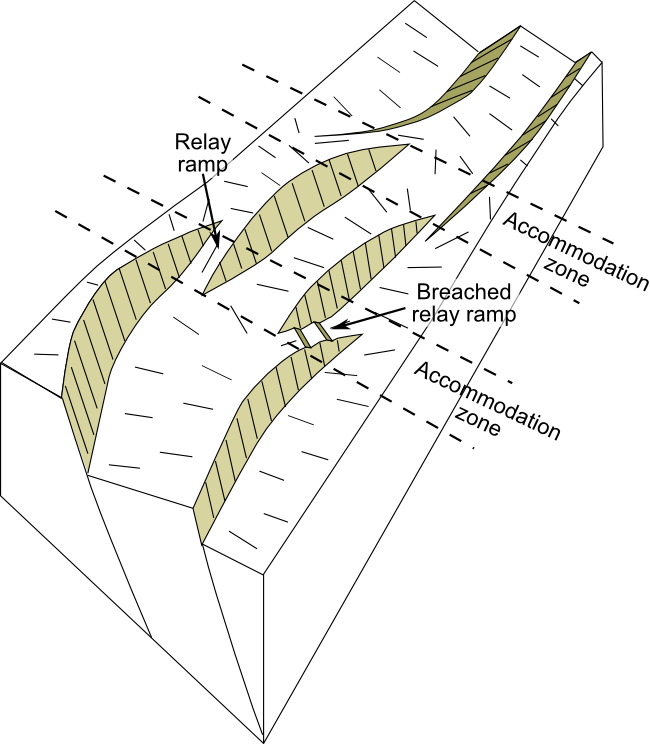
Areas of thick colder lithosphere, such as the Baikal Rift, have segment lengths in excess of 80 km, while in areas of warmer thin lithosphere, segment lengths may be less than 30 km.[5] Along the axis of the rift the position, and in some cases the polarity (the dip direction), of the main rift bounding fault changes from segment to segment. Segment boundaries often have a more complex structure and generally cross the rift axis at a high angle. These segment boundary zones accommodate the differences in fault displacement between the segments and are therefore known as accommodation zones.

Accommodation zones take various forms, from a simple relay ramp at the overlap between two major faults of the same polarity, to zones of high structural complexity, particularly where the segments have opposite polarity. Accommodation zones may be located where older crustal structures intersect the rift axis. In the Gulf of Suez rift, the Zaafarana accommodation zone is located where a shear zone in the Arabian-Nubian Shield meets the rift.[6]

Rift flanks or shoulders are elevated areas around rifts. Rift shoulders are typically about 70 km wide.[7] Contrary to what was previously thought, elevated passive continental margins (EPCM) such as the Brazilian Highlands, the Scandinavian Mountains and India's Western Ghats, are not rift shoulders.[7]

Rift development

[edit]

Rift initiation

[edit]

The formation of rift basins and strain localization reflects rift maturity. At the onset of rifting, the upper part of the lithosphere starts to extend on a series of initially unconnected normal faults, leading to the development of isolated basins.[8] In subaerial rifts, for example, drainage at the onset of rifting is generally internal, with no element of through drainage.

Mature rift stage

[edit]

As the rift evolves, some of the individual fault segments grow, eventually becoming linked together to form the larger bounding faults. Subsequent extension becomes concentrated on these faults. The longer faults and wider fault spacing leads to more continuous areas of fault-related subsidence along the rift axis. Significant uplift of the rift shoulders develops at this stage, strongly influencing drainage and sedimentation in the rift basins.[8]

During the climax of lithospheric rifting, as the crust is thinned, the Earth's surface subsides and the Moho becomes correspondingly raised. At the same time, the mantle lithosphere becomes thinned, causing a rise of the top of the asthenosphere. This brings high heat flow from the upwelling asthenosphere into the thinning lithosphere, heating the orogenic lithosphere for dehydration melting, typically causing extreme metamorphism at high thermal gradients of greater than 30 °C. The metamorphic products are high to ultrahigh temperature granulites and their associated migmatite and granites in collisional orogens, with possible emplacement of metamorphic core complexes in continental rift zones but oceanic core complexes in spreading ridges. This leads to a kind of orogeneses in extensional settings, which is referred as to rifting orogeny.[9]

Post-rift subsidence

[edit]

Once rifting ceases, the mantle beneath the rift cools and this is accompanied by a broad area of post-rift subsidence. The amount of subsidence is directly related to the amount of thinning during the rifting phase calculated as the beta factor (initial crustal thickness divided by final crustal thickness), but is also affected by the degree to which the rift basin is filled at each stage, due to the greater density of sediments in contrast to water. The simple 'McKenzie model' of rifting, which considers the rifting stage to be instantaneous, provides a good first order estimate of the amount of crustal thinning from observations of the amount of post-rift subsidence.[10][11] This has generally been replaced by the 'flexural cantilever model', which takes into account the geometry of the rift faults and the flexural isostasy of the upper part of the crust.[12]

Multiphase rifting

[edit]

Some rifts show a complex and prolonged history of rifting, with several distinct phases. The North Sea rift shows evidence of several separate rift phases from the Permian through to the Earliest Cretaceous,[13] a period of over 100 million years.

Rifting to break-up

[edit]

Rifting may lead to continental breakup and formation of oceanic basins. Successful rifting leads to seafloor spreading along a mid-oceanic ridge and a set of conjugate margins separated by an oceanic basin.[14] Rifting may be active, and controlled by mantle convection. It may also be passive, and driven by far-field tectonic forces that stretch the lithosphere. Margin architecture develops due to spatial and temporal relationships between extensional deformation phases. Margin segmentation eventually leads to the formation of rift domains with variations of the Moho topography, including proximal domain with fault-rotated crustal blocks, necking zone with thinning of crustal basement, distal domain with deep sag basins, ocean-continent transition and oceanic domain.[15]

Deformation and magmatism interact during rift evolution. Magma-rich and magma-poor rifted margins may be formed.[15] Magma-rich margins include major volcanic features. Globally, volcanic margins represent the majority of passive continental margins.[16] Magma-starved rifted margins are affected by large-scale faulting and crustal hyperextension.[17] As a consequence, upper mantle peridotites and gabbros are commonly exposed and serpentinized along extensional detachments at the seafloor.

Magmatism

[edit]
Volcano-tectonic landforms connected to rifting on Reykjanes Peninsula, Iceland: faults, fissures, elongated volcanoes of subglacial origin, postglacial lava fields

Many rifts are the sites of at least minor magmatic activity, particularly in the early stages of rifting.[18] Alkali basalts and bimodal volcanism are common products of rift-related magmatism.[19][20]

Recent studies indicate that post-collisional granites in collisional orogens are the product of rifting magmatism at converged plate margins.[citation needed]

Economic importance

[edit]

The sedimentary rocks associated with continental rifts host important deposits of both minerals and hydrocarbons.[21]

Mineral deposits

[edit]

SedEx mineral deposits are found mainly in continental rift settings. They form within post-rift sequences when hydrothermal fluids associated with magmatic activity are expelled at the seabed.[22]

Oil and gas

[edit]

Continental rifts are the sites of significant oil and gas accumulations, such as the Viking Graben and the Gulf of Suez Rift. Thirty percent of giant oil and gas fields are found within such a setting.[23] In 1999 it was estimated that there were 200 billion barrels of recoverable oil reserves hosted in rifts. Source rocks are often developed within the sediments filling the active rift (syn-rift), forming either in a lacustrine environment or in a restricted marine environment, although not all rifts contain such sequences. Reservoir rocks may be developed in pre-rift, syn-rift and post-rift sequences.

Effective regional seals may be present within the post-rift sequence if mudstones or evaporites are deposited. Just over half of estimated oil reserves are found associated with rifts containing marine syn-rift and post-rift sequences, just under a quarter in rifts with a non-marine syn-rift and post-rift, and an eighth in non-marine syn-rift with a marine post-rift.[24]

Examples

[edit]

See also

[edit]

References

[edit]

Further reading

[edit]
Revisions and contributorsEdit on WikipediaRead on Wikipedia
from Grokipedia
In geology, a rift is defined as a fundamental flaw in the continental crust along which the entire has ruptured under extension, leading to thinning of the crust and the development of normal fault systems. These zones represent sites of divergent tectonics, where plates or crustal blocks pull apart, often forming elongated valleys known as grabens flanked by uplifted shoulders or horsts. Rifts originate from tensile stresses that stretch the , causing it to fracture and subside in the central basin while the surrounding regions elevate due to isostatic rebound and asthenospheric upwelling. This process frequently triggers volcanism as rises through weakened crust, producing flood basalts, cinder cones, and fissures, alongside frequent from fault reactivation. If extension continues over tens of millions of years, a successful rift may evolve into a passive and oceanic spreading center; however, many become inactive "failed rifts" or aulacogens preserved in the geologic record. Notable examples of active continental rifts include the East African Rift System, a feature approximately 3,000 km long that extends from the Afar Triple Junction in to the southwest , potentially destined to separate the Somalian plate from the rest of Africa. In , the traces a north-south path from to , characterized by en echelon basins and ongoing extension, while the ancient Keweenawan Rift—also known as the Midcontinent Rift—formed around 1.1 billion years ago beneath the Lake Superior region but stalled before reaching the ocean stage. These structures not only shape landscapes but also influence resource distribution, including hydrocarbons in rift basins and metallic ores associated with rift-related .

Introduction

Definition

A rift is an elongated zone of crustal extension within the continental , where tectonic forces cause the crust to stretch, thin, and potentially fracture, leading to the development of linear depressions and, in some cases, the eventual breakup of continents into separate plates that form ocean basins. This occurs at divergent plate boundaries, where the is pulled apart, allowing of hotter asthenospheric material. Key characteristics of rifts include their narrow width, typically ranging from tens to hundreds of kilometers, and their formation through normal faulting that creates fault-block mountains flanking central basins. These linear features often exhibit elevated topography due to isostatic uplift from lithospheric thinning, accompanied by volcanic activity from of the rising and in subsiding basins that fill with eroded material and volcanic debris. The geological concept of rifts was first described in the late 19th century through explorations of prominent features such as the in , with detailed accounts emerging from expeditions in the . Modern understanding of rifts as integral components of developed in the 1960s, following the accumulation of evidence from and global seismic data that revolutionized earth sciences. Rifts are distinct from strike-slip faults, which involve lateral shearing without significant extension, and subduction zones, which feature convergence and crustal consumption rather than divergence.

Role in Plate Tectonics

Continental rifts represent incipient divergent plate boundaries within the continental , where extensional forces lead to crustal thinning and the potential formation of new basins. In the framework of , these features mark sites where continents begin to split, serving as precursors to passive continental margins and, ultimately, mid-ocean ridges if extension progresses to . For instance, successful rifts like the one that formed the transitioned from continental extension to oceanic spreading, illustrating how rifts bridge intraplate deformation and full plate divergence. Rifting constitutes the initial breakup phase in the , a model describing the episodic assembly and disassembly of over hundreds of millions of years. During this stage, tensional stresses fracture a stable , often triggered by underlying mantle dynamics, leading to the separation of continental blocks and the inception of new ocean basins. A classic example is the fragmentation of the in the era, where rifting initiated the opening of the Atlantic Ocean, progressing from embryonic continental splitting to mature . Globally, continental rifts predominantly occur in intraplate settings, away from established plate boundaries, and are influenced by far-field forces such as slab pull from distant zones or localized upwelling from plumes. Unlike oceanic spreading centers, which operate at established divergent boundaries with consistent supply, continental rifts often exploit pre-existing lithospheric weaknesses and exhibit variable success rates, with many failing to reach breakup. Prominent examples include the East African Rift System, driven partly by the African Superplume, and the in , contrasting with more uniform oceanic ridges. Observational evidence from seismic imaging and GPS measurements confirms active extension in these zones, with rates typically ranging from 1 to 10 mm/year, indicating ongoing plate boundary formation. In the , for example, GPS data reveal extension rates of approximately 6 ± 1.5 mm/year near the northern segment, localized along fault systems and accompanied by that highlights the dynamic interplay of tectonic forces. Such data underscore rifts' role in accommodating continental deformation within the broader plate tectonic regime.

Causes and Mechanisms

Driving Forces

The initiation and sustenance of continental rifting are primarily driven by far-field tectonic stresses originating from global plate boundary interactions and by active mantle processes such as upwelling plumes. Far-field stresses, including slab pull from subducting oceanic lithosphere and collisional forces at convergent margins, transmit extensional forces across plates to weak intracontinental zones, promoting localized and faulting. Slab pull represents a dominant component, with force magnitudes estimated at around 30 TN/m, sufficient to drive plate velocities that are three to four times faster for plates with active compared to those without. These stresses are particularly effective in edge-driven rifting scenarios, where proximity to plate boundaries amplifies the tensile regime, as seen in the influenced by the Arabia-Eurasia collision. Mantle plumes provide an additional key driver through thermal destabilization of the , inducing buoyancy-driven upwelling and weakening that localizes extension in intraplate settings. Proposed as narrow, deep-sourced convection cells rising from the core-mantle boundary, plumes elevate dynamic by 700–1400 m and generate extensional forces of about 3 TN/m per kilometer of uplift, while associated further reduces lithospheric strength by up to an . In plume-dominated rifts, such as the system, these processes combine with far-field stresses to sustain extension, though intraplate examples like the highlight plumes' role in initiating rifting far from plate edges. Quantitative models illustrate how these forces lead to strain localization, with the extension model depicting uniform lithospheric stretching that thins the crust and mantle, producing and elevated heat flow in rift basins. Extension rates vary by rift type, typically 5–7 mm/yr in plume-influenced intraplate settings like the versus 15–25 mm/yr in stress-driven edge rifts like the , reflecting the interplay of force magnitudes and lithospheric resistance. Evidence for plume contributions includes geochemical signatures in rift basalts, such as high ³He/⁴He ratios (up to 15 Rₐ) and ocean island basalt (OIB)-like enrichments (e.g., high Nb/Y), indicating a deep, primordial mantle source distinct from shallow asthenospheric melting. These signatures, observed in Ethiopian and Kenyan lavas, support plume upwelling as a critical driver in sustaining prolonged rifting phases.

Lithospheric Processes

The lithosphere in continental rifts undergoes significant thinning in response to extensional forces, primarily through a combination of brittle deformation in the upper crust and ductile flow in the lower crust and mantle. Brittle faulting accommodates extension via normal fault systems that create grabens and horsts, while ductile processes involve viscous flow and shear zones that redistribute material at depth, allowing the crust to thin without fracturing extensively. This dual mechanism enables overall lithospheric extension factors (β) of 50-100% or more, where β represents the of initial to final crustal thickness, as observed in mature rift systems. Lithospheric weakening plays a crucial role in facilitating these thinning processes by reducing the mechanical strength of the crust and mantle. Magmatic intrusions, often associated with , lower the of the lower crust and mantle through thermal softening, promoting localized strain and further extension. Additionally, fluid infiltration along fault zones can weaken the brittle upper crust by promoting , hydration, and elevated pore pressures that reduce frictional resistance. These factors collectively lower the yield strength of the , enabling prolonged rifting. Theoretical models describe rifting as either symmetric or asymmetric, influencing the distribution of . Symmetric rifting, akin to pure-shear deformation, involves uniform extension across a central zone with balanced faulting on both sides, suitable for wide rifts with distributed strain. In contrast, asymmetric rifting features simple-shear mechanisms along low-angle detachment faults, leading to one-sided and exhumation of lower crustal and mantle rocks, as exemplified in magma-poor margins. Observational evidence from anomalies reveals negative Bouguer anomalies over rift axes due to crustal and mantle thinning, while receiver function studies indicate Moho uplift, with depths shallowed by 10-15 km beneath active rifts like the .

Geometry and Structure

Fault Systems

In continental rifts, the dominant fault types are high-angle normal faults that typically dip at 45°–60° and accommodate extension through the formation of asymmetric half-grabens. These structures feature a major border fault on one side, with the hanging wall tilted toward the fault, while the opposite side forms a less steep or minor antithetic faults. Border faults, which define the rift margins, can extend up to 100 km in length and accumulate significant displacement, controlling the overall of the rift system. Rift fault patterns vary based on the orientation of extension relative to pre-existing structures, with orthogonal rifting producing symmetric arrays of long, straight border faults perpendicular to the extension direction and intra-rift faults that are similarly aligned. In contrast, oblique rifting, which occurs when extension is at an angle to the rift trend, results in asymmetric patterns with faults oriented obliquely to the rift axis. Transtensional settings, common in oblique rifts, often develop en echelon arrays of normal and strike-slip faults that segment the rift into offset basins, facilitating strain partitioning between extension and shear. Over time, rift faults evolve through several key processes that enhance their efficiency in accommodating extension. Many normal faults exhibit listric geometry, curving concave-upward to flatten into ductile shear zones at depths of 10–15 km, which allows for greater displacement without excessive crustal thinning. The rolling hinge mechanism further modifies fault dip, where isostatic rebound of the footwall progressively rotates and flattens the fault plane, enabling continued slip on what becomes a low-angle detachment at depth. Fault linkage is a critical evolutionary step, as isolated segments propagate, interact via breach or structures, and coalesce to form longer, more mature faults capable of handling larger offsets. Seismically, rift faults exhibit throws of 1–5 km, with border faults often accumulating the majority of displacement and generating moderate to large earthquakes (magnitude 5–7) along their lengths. patterns typically cluster along active fault segments, showing shallow focal depths (5–15 km) and normal faulting mechanisms that reflect ongoing extension, though activity may migrate as faults link and new segments activate. These patterns highlight the role of fault maturity in controlling , with mature border faults posing risks for prolonged rupture propagation.

Basin Characteristics

Rift basins exhibit diverse morphological configurations, primarily manifesting as half-grabens and full-grabens, with accommodation zones delineating distinct segments. Half-grabens, the most common type, form asymmetric depressions bounded by a dominant border fault on one side and a gently dipping antithetic fault or flexure on the other, resulting in a tilted basin floor that facilitates sediment accumulation toward the main fault. Full-grabens, less prevalent but observed in symmetric rift settings, feature parallel normal faults on both margins, creating a central zone without pronounced asymmetry. Accommodation zones serve as transitional regions between adjacent half-grabens, often involving complex fault interactions or transfer faults that accommodate changes in fault polarity and segment the overall rift architecture, as exemplified in the Rift where such zones separate the North, Central, and South basins. In terms of scale, continental rift basins typically extend 100–1000 km in length along the rift axis, reflecting segmented fault systems, while achieving subsidence depths of 5–10 km through combined faulting and flexural mechanisms. Flexural subsidence plays a key role in basin evolution, arising from the elastic response of the lithosphere to loading by syn-rift sediments and unloading along fault margins, which broadens the basin and enhances accommodation space beyond pure fault-controlled drop. Surface expressions of rift basins include prominent rift valleys, steep escarpments, and volcanic plateaus. Rift valleys form as elongated lowlands within depressions, often hosting lakes or fluvial systems, while escarpments develop along active border faults as sharp topographic rises marking the rift flanks. Volcanic plateaus emerge in areas of significant , such as the volcano-sedimentary terrains flanking the basins, where basaltic flows cap uplifted margins. Geophysically, rift basins are characterized by elevated heat flow and low-velocity zones indicative of thinned and asthenospheric upwelling. Heat flow values in rift settings, such as the , exceed surrounding cratonic regions, often ranging from 80–100 mW/m² due to enhanced . Low-velocity zones appear in the beneath rift axes, with P-wave velocities dropping to approximately 7.6 km/s at depths of 90 km, signaling and reduced rigidity. These signatures, coupled with crustal thinning to around 30 km, underscore the thermal weakening that sustains rifting.

Stages of Development

Initiation Phase

The initiation phase of continental rifting represents the early stage where extensional deformation begins to localize within the , often exploiting pre-existing zones of weakness such as ancient suture zones, faults, or rheological heterogeneities. Strain localization occurs as tectonic forces induce brittle fracturing in the upper crust and ductile shear zones in the lower crust and mantle, leading to the development of an initial array of small-scale, distributed normal faults that accommodate minor extension. This process is typically driven by far-field tectonic stresses, including slab pull from distant zones or mantle convective forces, which generate extensional stresses on the order of 10-30 MPa. The duration of the initiation phase commonly spans 10-50 million years, during which total extension remains low, generally less than 10% crustal thinning, with rates often around 1 mm/year or less, resulting in diffuse deformation across broad regions rather than focused basins. Precursors to rifting include pre-rift uplift associated with dynamic from underlying mantle plumes or lithospheric , which can elevate the surface by several hundred meters, and minor reflecting early stress accumulation along incipient faults. For instance, in the , uplift preceded faulting by several million years, linked to the African Superplume. Two primary models describe rift initiation: reactive and magmatic. In the reactive model, deformation localizes passively along inherited crustal weaknesses under plate-boundary forces, without significant melt involvement, as seen in numerical simulations of the Rhine Graben where strain softens the through fault maturation. Conversely, the magmatic model involves active of hot mantle material, such as plumes, that weakens the via heating and , promoting fault arrays; simulations of the demonstrate how plume-induced buoyancy forces accelerate strain localization by factors of up to 10 times once thermal weakening exceeds a threshold. Numerical models, including finite-element simulations, illustrate that in reactive scenarios, initial fault arrays form over 5-10 million years with extension velocities increasing from <1 mm/year to 5-10 mm/year as necking instability develops, while magmatic cases show faster localization due to melt-enhanced .

Mature Phase

The mature phase of continental rifting represents the period of intensified extension following initial localization, characterized by focused strain localization within the as the thins progressively toward eventual breakup. During this stage, deformation concentrates along major border faults and intra-rift structures, leading to the development of large-offset normal faults that accommodate the bulk of the extension. These faults often exhibit displacements exceeding 10 km, as observed in continental core complexes within wide rifts, such as those in the Whipple Mountains of the . Significant subsidence occurs in the hanging walls of these faults, forming deep sedimentary basins with depths reaching up to 10 km due to combined tectonic and isostatic adjustment. This phase typically lasts 20 to 100 million years, with total extension rates ranging from 50% to 200% (β factors of 1.5 to 3), reflecting substantial crustal stretching that can hyper-extend the in successful rifts. Extension velocities accelerate markedly, often increasing tenfold from initial millimeter-per-year rates to centimeter-per-year scales once the weakens sufficiently through and potential magmatic underplating. Rifting during this mature stage is frequently multiphase, interrupted by periods of tectonic quiescence lasting 20 to 60 million years, during which thermal relaxation and cooling allow partial lithospheric strengthening before reactivation. For instance, the Turkana Rift in experienced dormancy from 60 to 50 million years ago, followed by renewed extension 25 to 15 million years ago. These quiescence intervals complicate the rift by enabling strain migration or reactivation of inherited weaknesses, altering the locus of extension between phases. Key indicators of the mature phase include the accumulation of thick syn-rift sedimentary sequences, often several kilometers deep, that fill subsiding basins and record the depositional response to ongoing faulting. Increased also marks this stage, with potential for large-magnitude events up to moment magnitude (M_w) ~7, driven by strain accumulation along mature fault systems. Such features underscore the transition to a structurally mature rift capable of sustaining prolonged extension prior to potential continental separation.

Breakup and Post-Rift

The breakup phase represents the culmination of continental rifting, where extreme lithospheric extension leads to the complete separation of continents and the initiation of oceanic spreading. This stage involves significant unroofing, with exhumation of the lower crust and through low-angle detachment faults, often resulting in the exposure of serpentinized peridotites at the surface or shallow depths. In hyper-extended domains, the continental crust thins dramatically to thicknesses below 10 km over widths exceeding 100 km, accommodating up to 300-400 km of total extension prior to final separation; these domains form as a consequence of ductile flow in the lower crust and localized necking near the rift axis. Transition to ocean basin formation occurs through the development of proto-oceanic crust, a hybrid lithospheric domain transitional between continental and mature oceanic crust, often underlain by exhumed mantle rather than full magmatic underplating. Seaward-dipping reflectors (SDRs), thick packages of subaerial to shallow-marine basalt flows dipping oceanward at 10-30 degrees, mark this initiation and are emblematic of volcanic rifted margins, recording syn-breakup magmatism and the onset of seafloor spreading. These features, typically 5-15 km thick, evolve from rift-related volcanism into the earliest oceanic sequences, as observed in margins like the South Atlantic where they overlie hyper-extended continental crust. Post-breakup evolution is characterized by thermal driven by conductive cooling and rethickening of the asthenosphere-depleted , following the principles of the uniform stretching model. This process generates broad sag basins through isostatic adjustment, with accumulating 2-5 km of sediment accommodation over 100-150 million years, as the recovers from initial factors of 2-5 or more. In hyperextended margins, may be delayed due to persistent small-scale and proximity to the nascent spreading , maintaining elevated heat flow for up to 100 million years and resulting in thinner-than-expected lithospheric thicknesses. The enduring structural legacy manifests in passive continental margins, where arrays of tilted fault blocks from the rift stage are preserved beneath a veneer of post-rift sediments, delineating proximal to distal domains with varying degrees of hyper-extension. These architectures, including rotated half-grabens and detachment systems, influence margin asymmetry and control the distribution of post-rift sedimentary prisms, as seen in classic examples like the North Atlantic and southern South Atlantic margins.

Associated Geological Processes

Magmatism

plays a central role in continental rifting by facilitating extension through thermal weakening and intrusive/extrusive activity, often triggered by lithospheric thinning that enables decompression of the . In many rifts, igneous activity is predominantly syn-rift, involving underplating of melts at the base of the crust and emplacement of dikes that propagate along the rift axis to accommodate strain. This underplating can postpone by maintaining thick crust during early rifting stages. Dike swarms, such as those in the northern Rift, form early syn-rift intrusive networks that localize deformation over scales of 50-100 km. Rift-related magmatism is frequently bimodal, dominated by basalts and rhyolites or trachytes, reflecting of the followed by extensive fractional and limited crustal assimilation. In magma-rich systems like the , this bimodality arises during the mature phase, with peralkaline rhyolites forming from evolved basaltic parents stored in crustal chambers. Volumes of emplaced vary widely but can reach 10-100 km³ per km of rift length in plume-influenced settings, where elevated mantle temperatures enhance melt production. Plume activity, as in the Ethiopia-Afar system, amplifies these volumes by promoting widespread within-plate and continental provinces, such as the Oligocene Trap Series covering over 600,000 km². Geochemically, rift magmas often exhibit ocean island basalt (OIB)-like signatures, characterized by enriched trace elements (e.g., high Nb/Y ratios) and radiogenic isotopes indicative of melting rather than lithospheric sources. This is evident in the Main Ethiopian Rift, where basalts show low δ¹⁸O values (5.5-6.5‰) and Rb/Nb ratios below 1.5, pointing to minimal interaction with fusible Pan-African crust and dominant decompression melting of fertile mantle. Such compositions distinguish rift from arc-related volcanism and underscore the role of upwelling in driving rift evolution across systems like the , where OIB-type basalts reflect similar processes.

Sedimentation

Sedimentation in rift basins is fundamentally shaped by the interplay of tectonic extension and depositional processes, resulting in distinct stratigraphic architectures and distributions. The stratigraphic record typically initiates with a pre-rift , where or non-deposition on older precedes the onset of rifting, creating a sharp boundary with overlying syn-rift . During the syn-rift phase, accumulate as wedge-shaped packages that progressively thicken toward active normal faults, filling hangingwall depocenters in structures. This thickening reflects fault-controlled , with growth strata—layers that thin away from faults and onlap older units—serving as key indicators of syndepositional . Following rift cessation, the post-rift stage features a broad sag basin due to lithospheric cooling and isostatic adjustment, promoting more laterally extensive and uniform layers over the tilted fault blocks. Depositional environments in rift basins vary systematically with proximity to fault zones and basin hydrology. In hangingwall depocenters, underfilled conditions often foster deep lacustrine systems, where fine-grained muds and carbonates accumulate in subsiding lows, while fluvial networks drain axial or marginal inputs. Alluvial fans develop at the mouths of fault-bounded canyons along footwall scarps, supplying coarse detritus to adjacent basins, and transition basinward into braided or meandering fluvial systems that redistribute sediments toward central lows. These environments evolve as fault propagation and linkage alter drainage patterns, shifting from isolated, closed basins with playa lakes to open systems connected to regional rivers. The nature of sedimentation is governed by the relative rates of tectonic subsidence and sediment supply, which dictate whether basins become underfilled, balanced, or overfilled. High subsidence rates outpacing supply lead to starved depocenters dominated by lacustrine facies, whereas increased erosion from uplifted footwalls can overwhelm accommodation, promoting progradational fluvial and fan deltas. Climate fluctuations further modulate supply, with arid conditions favoring evaporites in closed lakes and humid regimes enhancing fluvial input. Facies belts reflect this gradient: coarse conglomerates and breccias prevail in proximal footwall-derived fans near faults, fining progressively to sandstones in medial fluvial zones and mudstones or evaporites in distal lacustrine centers. Such lateral and vertical facies variations preserve a record of rift progression, with syn-rift units often exceeding several kilometers in thickness in active depocenters.

Economic Significance

Hydrocarbon Resources

Rift basins are renowned for hosting substantial hydrocarbon accumulations, primarily due to their syn-rift sedimentary sequences that include organic-rich source rocks. These source rocks are typically lacustrine shales deposited in restricted, anoxic environments during active rifting, often containing Type I derived from algal blooms and preserving high (TOC) contents exceeding 2-5%. Such shales, as seen in the Lower sequences of the , exhibit excellent oil-prone potential, with types transitioning from mixed I-III in early rift phases to predominantly Type I in later stages, facilitating prolific oil generation. Hydrocarbons migrate into adjacent reservoirs and are trapped by structures inherent to rift tectonics. Reservoir rocks commonly comprise syn-rift sandstones and carbonates deposited in alluvial fans, fluvial systems, or lacustrine deltas within half-grabens, offering porosities up to 20-25%. Traps form primarily as fault blocks along listric normal faults, rollover anticlines in hanging-wall synclines, and stratigraphic pinch-outs at the margins of depocenters, effectively sealing hydrocarbons against basement highs or impermeable shales. These configurations are exemplified in the North Sea rift system, where fault-block traps host over 70% of discovered fields, having produced more than 47 billion barrels of oil equivalent as of 2025 and serving as a major supplier to Europe's energy needs. Rapid subsidence and burial in rift basins accelerate source rock maturation, often reaching the oil window within 10-20 million years post-deposition. This enhanced , driven by thinned and elevated heat flow, promotes efficient expulsion, with modeling indicating peak generation during late syn-rift to early post-rift phases. However, faces challenges such as fault seal , where reactivation can breach traps and cause leakage, and overpressures from disequilibrium compaction, complicating and risking blowouts. These factors necessitate advanced seismic and geomechanical modeling to assess trap stability.

Mineral Deposits

Rift-related mineral deposits encompass a variety of metallic and non-metallic resources formed through and associated igneous activity. Volcanogenic massive sulfide (VMS) deposits are prominent in rift volcanics, where submarine or volcanic environments facilitate the precipitation of sulfide minerals rich in , , lead, and precious metals. These deposits form in extensional settings akin to back-arc basins or rifted continental margins, with bimodal mafic-felsic assemblages providing the necessary heat and fluids for mineralization. Pegmatites associated with alkaline intrusions represent another key type, occurring as coarse-grained differentiates in anorogenic settings within continental rifts. These pegmatites, often enriched in rare earth elements (REE), , and , develop in peralkaline granites or syenites during late-stage magmatic differentiation. In rift valleys like the Oslo Rift, such intrusions host pegmatites with accessory minerals such as , reflecting trace-element enrichment from mantle-derived melts. Gold mineralization is a significant example in Archean greenstone belts, which originated in ancient rift systems. These belts, such as the Abitibi in and those in , contain orogenic deposits within supracrustal sequences deformed during rift evolution, with production exceeding 6,100 metric tons from the Abitibi alone. Evaporites, including and , accumulate as non-metallic resources in pull-apart basins along strike-slip faults within rifts, as seen in isolated grabens of the coast where marine incursions lead to thick saline sequences. Formation of these deposits involves hydrothermal systems driven by rift , where ascending mantle-derived melts heat circulating fluids that leach and transport metals through fractures. Sedimentary concentration further enhances non-metallic deposits like evaporites, as restricted basin circulation promotes and in arid, extensional lows. In VMS and systems, magmatism supplies the thermal energy for fluid , often linking to alkaline or tholeiitic intrusions. Economically, rift settings yield substantial and resources, particularly in the rift's Deep, where hydrothermal brines have deposited an estimated 0.4 million tonnes of and 1.9 million tonnes of in metalliferous muds. These reserves, analogous to ancient VMS, underscore the potential of active rifts for modern , though extraction challenges persist due to deep-sea conditions.

Notable Examples

East African Rift System

The East African Rift System (EARS) represents the archetypal active continental rift, spanning approximately 3,000 km from the Afar Triple Junction in northern to the coastal lowlands of . This intra-continental feature divides the African plate into the Nubian and Somalian plates, forming a complex network of rift branches that include the Eastern (Kenyan) and Western (Albertine) rifts, linked by accommodation zones. The system originated in the Eocene to (around 45–29 Ma) with initial volcanism in the , evolving into a zone of ongoing lithospheric extension driven by mantle upwelling. Extension across the EARS occurs at rates of 6–7 mm/year in the northern segments, such as the , decreasing southward to 1–4 mm/year, reflecting variable plate boundary forces and plume interactions. Key geomorphic features include basins bounded by normal faults, with volcanic provinces dominating the landscape; notable examples are the and the , where , an isolated reaching 5,895 m, exemplifies rift-flank alkaline unrelated to . The rift valleys contain several of Africa's , including in the Western Branch, a 673 km-long, 1,470 m-deep tectonic basin that preserves a record of rift evolution through lacustrine sedimentation. Oblique rifting characterizes segments like the Kenyan Rift, where extension directions deviate 30–45° from the structural trend, leading to partitioned strike-slip and normal faulting along transfer zones. Currently, the EARS exhibits signs of incipient continental breakup, with the northern transitioning toward oceanic spreading, as evidenced by in the and extensions. Seismic activity is concentrated along border faults and volcanic centers, with moderate earthquakes (M_w 5–7) reflecting brittle failure in the upper crust, while lower-crustal indicates migration. Magmatic processes are active, including dyke intrusions and eruptions from shields like Meru and Oldoinyo Lengai, a unique . These dynamics highlight the system's role as a natural laboratory for rifting. Research on the EARS draws insights from paleo-rifts, such as the Anza Rift in , which reveal how inherited crustal weaknesses influence and why some branches failed while others persisted. Modern monitoring through GPS networks and InSAR has mapped strain accumulation, showing localized extension maxima up to 13 mm/year in the Natron Basin and linking seismic swarms to magmatic unrest, as during the 2007 Karonga sequence. further elucidates contributions, with low-velocity anomalies beneath the Craton indicating asthenospheric that sustains . Recent 2025 studies highlight climate-induced acceleration of rifting near through increased fault activity from lake level changes and the role of failed rifts in strengthening continental plates, informed by geophysical experiments in . These multidisciplinary approaches underscore the EARS's value in understanding continental breakup mechanics.

Rio Grande Rift

The is a continental rift zone characterized by east-west crustal extension, stretching approximately 1,000 kilometers from central through to western and northern Chihuahua, . It consists of a series of en echelon, north-south trending basins separated by basement-cored mountain ranges, with the rift axis generally following the course of the river. The structure formed through lithospheric thinning and faulting, superimposing on older Laramide-age structures from the , and represents an active intraplate rift not directly at a plate boundary. Rifting initiated around 35–30 million years ago in the southern segments, with northern extension beginning about 26–20 million years ago, driven by the westward migration of the relative to the stable Great Plains . Extension peaked between 16 and 10 million years ago, achieving total crustal stretching of 7–22% across the region, locally up to 170% near , resulting in a thinned crust averaging 35–40 kilometers thick compared to over 50 kilometers in surrounding areas. A 2025 study in Trans-Pecos Texas reveals rotation of crustal extension directions and narrowing of rift faulting, based on new fault-kinematic data and U-Pb dating. The basins, such as the deep (up to 3 kilometers of sediments) and the , are asymmetric half-grabens bounded by high-angle normal faults, with volcanic and sedimentary infill dominating the . Associated includes widespread basalt-rhyolite from mantle upwelling, forming clusters that young southward, and recent activity like the 5,000-year-old flows at Valley of Fires. Sedimentation features alluvial fans, playa lakes, and evaporites, exemplified by the dunes of White Sands from the ancient Lake Otero. The rift's significance lies in its control over regional hydrology, with basin aquifers supporting major population centers like Albuquerque and El Paso, and its role in ongoing tectonic processes. Seismic activity reflects active faulting, with paleoseismic evidence indicating prehistoric earthquakes of magnitude 7.0–7.5 along border faults, though current rates are low to moderate; the structure continues to widen at about 2.5 centimeters per century based on GPS measurements. Economically, it hosts geothermal resources from thinned crust and minor mineral deposits tied to volcanism, while influencing biodiversity in the ecosystems. Research, including seismic tomography experiments like LA RISTRA, continues to refine models of its three-dimensional structure and mantle dynamics.

References

Add your contribution
Related Hubs
Contribute something
User Avatar
No comments yet.