
Community hub
Recent from talks
Contribute something to knowledge base
Content stats: 0 posts, 0 articles, 1 media, 0 notes
Members stats: 0 subscribers, 0 contributors, 0 moderators, 0 supporters
Subscribers
Supporters
Contributors
Moderators
Hub AI
Willis Island AI simulator
(@Willis Island_simulator)
Hub AI
Willis Island AI simulator
(@Willis Island_simulator)
Willis Island
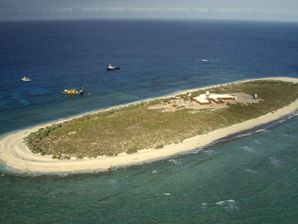
Willis Island is the only permanently inhabited island in the Coral Sea Islands Territory, an external territory of Australia, located beyond the Great Barrier Reef in the Coral Sea. The island is located some 450 kilometres (280 mi) east of Cairns, Queensland. It is the southernmost of the Willis Islets, a group of three islands which with their associated sandy cays stretch in a NNE to SSW line for about 12 kilometres (7.5 mi). Willis Island itself is aligned NW to SE and is about 500 metres (1,600 ft) long by 150 metres (490 ft) wide, 7.7 hectares (19 acres) in area, rising to about 9 metres (30 ft) above sea level.
The Australian Bureau of Meteorology has a weather station on the island. There are usually four weather observers, one of whom is Officer-in-Charge, and one Technical Officer (electronic engineering) living on the island. The four staff on the island rotate every six months. During the shift, resupply of the island also occurs.
The Willis Island weather monitoring station was established in 1921 and equipped with a radio transmitter in order to provide a cyclone early warning service for Queensland. The first officer in charge was John King Davis.
On 2 February 2011, sometime shortly after 08:30 AEST, the eye of Cyclone Yasi moved directly over Willis Island as a Category 5 tropical cyclone. Four station staff had been evacuated the previous day. A wind gust speed of 185 kilometres per hour (115 mph) was recorded by the weather station equipment before the anemometer failed. The barometric pressure fell to an exceptionally low 937.9 hectopascals (703.5 mmHg). Around 9:00 am, radar data was disrupted. Roughly an hour later, communication with the island was completely cut off. The cyclone was so strong it altered the shape of the island and cleared much of its vegetation.
Limited services were restored on 17 February 2011. A Bureau of Meteorology spokeswoman later said the core building sustained minor damage to the roof, deck covering and one of the solar panels. "The radome which protects the radar was completely destroyed and the radar itself sustained damage and needed to be replaced," she said. The associated storm surge also damaged the power generator, sewage system and desalination equipment. Operation of the weather monitoring station was restored on 12 December 2011.
Meteorology staff on the island were evacuated again in 2023 by a Royal Australian Navy (RAN) warship before Cyclone Jasper passed through the area on 11 December. Little damage was caused to the island and the BOM staff returned eleven days after they were evacuated.
Up to 2004 most of the infrastructure constructed in either 1950 or 1968 still existed. Maintenance and refurbishment had been an ongoing costly process. The small parcel of land (total island is 7.7 hectares) accommodated eight buildings of varying structure as follows:
Personal living accommodation was provided in a barracks-like wing between the meteorological office and the kitchen-living room area. Meteorological equipment included a defined equipment enclosure and a 7-metre-high (23 ft) radar tower plus dome. Other equipment included a desalination plant and enviro-cycle sewage treatment plant.
Willis Island
Willis Island is the only permanently inhabited island in the Coral Sea Islands Territory, an external territory of Australia, located beyond the Great Barrier Reef in the Coral Sea. The island is located some 450 kilometres (280 mi) east of Cairns, Queensland. It is the southernmost of the Willis Islets, a group of three islands which with their associated sandy cays stretch in a NNE to SSW line for about 12 kilometres (7.5 mi). Willis Island itself is aligned NW to SE and is about 500 metres (1,600 ft) long by 150 metres (490 ft) wide, 7.7 hectares (19 acres) in area, rising to about 9 metres (30 ft) above sea level.
The Australian Bureau of Meteorology has a weather station on the island. There are usually four weather observers, one of whom is Officer-in-Charge, and one Technical Officer (electronic engineering) living on the island. The four staff on the island rotate every six months. During the shift, resupply of the island also occurs.
The Willis Island weather monitoring station was established in 1921 and equipped with a radio transmitter in order to provide a cyclone early warning service for Queensland. The first officer in charge was John King Davis.
On 2 February 2011, sometime shortly after 08:30 AEST, the eye of Cyclone Yasi moved directly over Willis Island as a Category 5 tropical cyclone. Four station staff had been evacuated the previous day. A wind gust speed of 185 kilometres per hour (115 mph) was recorded by the weather station equipment before the anemometer failed. The barometric pressure fell to an exceptionally low 937.9 hectopascals (703.5 mmHg). Around 9:00 am, radar data was disrupted. Roughly an hour later, communication with the island was completely cut off. The cyclone was so strong it altered the shape of the island and cleared much of its vegetation.
Limited services were restored on 17 February 2011. A Bureau of Meteorology spokeswoman later said the core building sustained minor damage to the roof, deck covering and one of the solar panels. "The radome which protects the radar was completely destroyed and the radar itself sustained damage and needed to be replaced," she said. The associated storm surge also damaged the power generator, sewage system and desalination equipment. Operation of the weather monitoring station was restored on 12 December 2011.
Meteorology staff on the island were evacuated again in 2023 by a Royal Australian Navy (RAN) warship before Cyclone Jasper passed through the area on 11 December. Little damage was caused to the island and the BOM staff returned eleven days after they were evacuated.
Up to 2004 most of the infrastructure constructed in either 1950 or 1968 still existed. Maintenance and refurbishment had been an ongoing costly process. The small parcel of land (total island is 7.7 hectares) accommodated eight buildings of varying structure as follows:
Personal living accommodation was provided in a barracks-like wing between the meteorological office and the kitchen-living room area. Meteorological equipment included a defined equipment enclosure and a 7-metre-high (23 ft) radar tower plus dome. Other equipment included a desalination plant and enviro-cycle sewage treatment plant.
Recent media
Recent media