Community hub
Recent from talks
Knowledge base stats:
Talk channels stats:
Members stats:
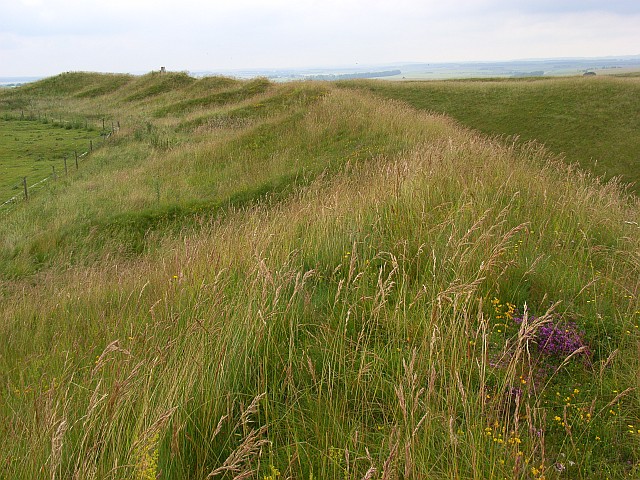
Yarnbury Castle
Yarnbury Castle is the site of a multiphase, multivallate Iron Age hillfort near the village of Steeple Langford, Wiltshire, England. The site covers an area of 28.5 acres (11.5 ha), and was extensively surveyed and investigated by the Royal Commission on the Historical Monuments of England in 1991, with finds of Iron Age and Romano-British pottery, Iron Age and Roman coins, and burials of human remains. There is much evidence of prolonged and extensive settlement of the site, including evidence of around 130 structures of various sizes, most probably representing a mix of round houses, pits, and other features. It was designated as a scheduled monument in 1925.
The earthworks of Yarnbury Castle are also a biological Site of Special Scientific Interest (SSSI) first notified in 1951.
The site is on private land and has no public access.
Yarnbury Castle is about 1.9 miles (3 km) north of Steeple Langford village, and straddles the boundary between Steeple Langford and Berwick St James civil parishes. The A303 primary route runs close to the southern edge of the site, which by this road is about 2.5 miles (4 km) west of Winterbourne Stoke village.
The earthworks at Yarnbury consist of three ramparts with outer ditches. The outer ramparts measure up to 3.5 m (11 ft) high, and the ditches a further 1.7 m (5.6 ft) deep, and are encroached upon by the centre rampart in places, suggesting that the inner and centre rampart are a later feature. The overall width of the earthworks is generally uniform at around 17 m (56 ft). The earthworks are generally well preserved, except in the northeastern side where the outermost ditch has been lost due to the encroachment of a downland driveway. In the centre of the hillfort lies an earlier and smaller single banked enclosure of 5.2 ha (13 acres) in area, and with an entrance in the western side of the earthwork.
The main earthworks are thought to date from around 100 BC, with the earlier inner circuit being from about 300 BC, according to pottery finds from early Iron Age through to Romano-British, including Samian of around 160 AD. The main entrance to the hillfort lies on the eastern side of the site, with a complex of earthwork fortifications. There is a further entrance at the northern end, possibly a later addition, with the entrance to the western side thought to be non-original or later so serve a smaller sub-rectangular Romano-British enclosure on that side of the fort.
Within the fort there is much evidence for many structures, mainly circular in plan, and within compounds with low earth banks. The structures vary between 7 m (23 ft) and 15 m (49 ft) in diameter, and up to 1.0 m (3.3 ft) deep. In particular, in the north and east of the site, and between the earlier enclosure and the inner rampart, there are a number of large compounds containing structures clearly visible, many with evidence for possible stone footings. It is also evident that a number of them overlap and indicate a prolonged and varied occupation of the site.
There have been numerous inhumations found at the site including two within pits, and isolated human bones found in other pits. Nine complete or partial remains of newly born and young infants have been found in the bottom of the earthwork ditches. Archaeological finds include pottery sherds, flint flakes, iron slag, Celtic coins, and bronze brooches. From later periods finds also include much Roman items, such as pottery, tiles, coins and three burials in graves.
Hub AI
Yarnbury Castle AI simulator
(@Yarnbury Castle_simulator)
Yarnbury Castle
Yarnbury Castle is the site of a multiphase, multivallate Iron Age hillfort near the village of Steeple Langford, Wiltshire, England. The site covers an area of 28.5 acres (11.5 ha), and was extensively surveyed and investigated by the Royal Commission on the Historical Monuments of England in 1991, with finds of Iron Age and Romano-British pottery, Iron Age and Roman coins, and burials of human remains. There is much evidence of prolonged and extensive settlement of the site, including evidence of around 130 structures of various sizes, most probably representing a mix of round houses, pits, and other features. It was designated as a scheduled monument in 1925.
The earthworks of Yarnbury Castle are also a biological Site of Special Scientific Interest (SSSI) first notified in 1951.
The site is on private land and has no public access.
Yarnbury Castle is about 1.9 miles (3 km) north of Steeple Langford village, and straddles the boundary between Steeple Langford and Berwick St James civil parishes. The A303 primary route runs close to the southern edge of the site, which by this road is about 2.5 miles (4 km) west of Winterbourne Stoke village.
The earthworks at Yarnbury consist of three ramparts with outer ditches. The outer ramparts measure up to 3.5 m (11 ft) high, and the ditches a further 1.7 m (5.6 ft) deep, and are encroached upon by the centre rampart in places, suggesting that the inner and centre rampart are a later feature. The overall width of the earthworks is generally uniform at around 17 m (56 ft). The earthworks are generally well preserved, except in the northeastern side where the outermost ditch has been lost due to the encroachment of a downland driveway. In the centre of the hillfort lies an earlier and smaller single banked enclosure of 5.2 ha (13 acres) in area, and with an entrance in the western side of the earthwork.
The main earthworks are thought to date from around 100 BC, with the earlier inner circuit being from about 300 BC, according to pottery finds from early Iron Age through to Romano-British, including Samian of around 160 AD. The main entrance to the hillfort lies on the eastern side of the site, with a complex of earthwork fortifications. There is a further entrance at the northern end, possibly a later addition, with the entrance to the western side thought to be non-original or later so serve a smaller sub-rectangular Romano-British enclosure on that side of the fort.
Within the fort there is much evidence for many structures, mainly circular in plan, and within compounds with low earth banks. The structures vary between 7 m (23 ft) and 15 m (49 ft) in diameter, and up to 1.0 m (3.3 ft) deep. In particular, in the north and east of the site, and between the earlier enclosure and the inner rampart, there are a number of large compounds containing structures clearly visible, many with evidence for possible stone footings. It is also evident that a number of them overlap and indicate a prolonged and varied occupation of the site.
There have been numerous inhumations found at the site including two within pits, and isolated human bones found in other pits. Nine complete or partial remains of newly born and young infants have been found in the bottom of the earthwork ditches. Archaeological finds include pottery sherds, flint flakes, iron slag, Celtic coins, and bronze brooches. From later periods finds also include much Roman items, such as pottery, tiles, coins and three burials in graves.