Recent from talks
Al-Khisas
Knowledge base stats:
Talk channels stats:
Members stats:
Al-Khisas
Al-Khisas (Arabic: الخصاص), also known as Khisas or Khissas, was a Palestinian Arab village in the Safad Subdistrict in Mandatory Palestine. It was located 31 kilometers (19 mi) northeast of Safed on a natural terrace about 100 meters (330 ft) wide that formed when Lake al-Hula receded. To the west of the village was a valley known as Wadi al-Hasibani through which ran the Hasbani River.
During the 1948 Palestine war, and as part of the Nakba, the village was attacked by the Palmach in a punitive raid and 10-15 of its residents were massacred. The village was subsequently depopulated and destroyed by Israeli forces. Today the Israeli kibbutz of HaGoshrim exists on the villages former lands.
The Arab geographer Yaqut al-Hamawi described al-Khisas as falling within the administrative jurisdiction of Banias in Syria.
Evidence of the long history of habitation in the village includes the nearby shrine of a local sage known as al-Shaykh 'Ali and the presence of rock-hewn tombs. Under the Ottoman Empire, al-Khisas was administered as part of a sanjak in the vilayet of Damascus, and was later redesignated a part the vilayet of Sidon (renamed the vilayet of Beirut).
In 1917, al-Khisas lay north of the Sykes Picot line, a straight line between the midpoint of the Sea of Galilee and Nahariya in the area to be incorporated under a French sphere of influence. The Syria-Lebanon-Palestine boundary was a product of the post-World War I Anglo-French partition of Ottoman Syria. British forces had advanced to a position at Tel Hazor against Turkish troops in 1918 and wished to incorporate all the sources of the river Jordan within the boundaries of British controlled Palestine. Due to the French inability to establish administrative control, the frontier between Syria and Palestine became 'fluid'. The international boundary between Palestine and Syria was finally set by joint agreement between Great Britain and France in 1923 in conjunction with the Treaty of Lausanne, after Britain had been given a League of Nations Mandate for Palestine in 1922; thus, al-Khisas came under British jurisdiction.
In the 1931 census of Palestine the population of Khisas was 386, all Muslims, in a total of 73 houses.
Types of land use in dunams in the village in 1945:
The land ownership of the village in dunams:
Hub AI
Al-Khisas AI simulator
(@Al-Khisas_simulator)
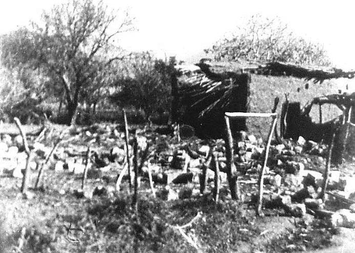
Al-Khisas
Al-Khisas (Arabic: الخصاص), also known as Khisas or Khissas, was a Palestinian Arab village in the Safad Subdistrict in Mandatory Palestine. It was located 31 kilometers (19 mi) northeast of Safed on a natural terrace about 100 meters (330 ft) wide that formed when Lake al-Hula receded. To the west of the village was a valley known as Wadi al-Hasibani through which ran the Hasbani River.
During the 1948 Palestine war, and as part of the Nakba, the village was attacked by the Palmach in a punitive raid and 10-15 of its residents were massacred. The village was subsequently depopulated and destroyed by Israeli forces. Today the Israeli kibbutz of HaGoshrim exists on the villages former lands.
The Arab geographer Yaqut al-Hamawi described al-Khisas as falling within the administrative jurisdiction of Banias in Syria.
Evidence of the long history of habitation in the village includes the nearby shrine of a local sage known as al-Shaykh 'Ali and the presence of rock-hewn tombs. Under the Ottoman Empire, al-Khisas was administered as part of a sanjak in the vilayet of Damascus, and was later redesignated a part the vilayet of Sidon (renamed the vilayet of Beirut).
In 1917, al-Khisas lay north of the Sykes Picot line, a straight line between the midpoint of the Sea of Galilee and Nahariya in the area to be incorporated under a French sphere of influence. The Syria-Lebanon-Palestine boundary was a product of the post-World War I Anglo-French partition of Ottoman Syria. British forces had advanced to a position at Tel Hazor against Turkish troops in 1918 and wished to incorporate all the sources of the river Jordan within the boundaries of British controlled Palestine. Due to the French inability to establish administrative control, the frontier between Syria and Palestine became 'fluid'. The international boundary between Palestine and Syria was finally set by joint agreement between Great Britain and France in 1923 in conjunction with the Treaty of Lausanne, after Britain had been given a League of Nations Mandate for Palestine in 1922; thus, al-Khisas came under British jurisdiction.
In the 1931 census of Palestine the population of Khisas was 386, all Muslims, in a total of 73 houses.
Types of land use in dunams in the village in 1945:
The land ownership of the village in dunams:
Recent media