Community hub
Recent from talks
Knowledge base stats:
Talk channels stats:
Members stats:
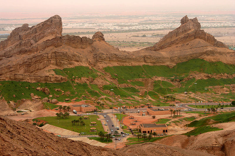
Al Ain
Al Ain (Arabic: ٱلْعَيْن, romanized: Al-ʿAyn, lit. 'The Spring') is a city in the Emirate of Abu Dhabi, United Arab Emirates, and the seat of the administrative division of the Al Ain Region. The city is bordered to the east by the Omani town of Al-Buraimi. Al Ain is the largest inland city in the Emirates, the fourth-largest city (after Dubai, Abu Dhabi, and Sharjah), and the second-largest in the Emirate of Abu Dhabi. The freeways connecting Al Ain, Abu Dhabi, and Dubai form a geographic triangle in the country, each city being roughly 130 kilometres (81 mi) from the others.
Al Ain is known as the "Garden City" (Arabic: مَدِيْنَة ٱلْحَدِيْقَة, romanized: Madīnat Al-Ḥadīqah, lit. 'City of The Garden') of Abu Dhabi, the UAE or the Gulf, due to its greenery, particularly with regard to the city's oases, parks, tree-lined avenues and decorative roundabouts, with strict height controls on new buildings, to no more than seven floors. According to one author, the oases around Al Ain and Al-Hasa in Saudi Arabia are the most important in the region of the Gulf.
The city is located approximately 160 kilometres (99 mi) east of the capital Abu Dhabi, and about 120 kilometres (75 mi) south of Dubai. The eastern region covers an area of approximately 13,100 km2 (5,100 sq mi). Oman lies to the east, Dubai and Sharjah to the north, Abu Dhabi to the west and the Empty Quarter desert and Saudi Arabia to the south. The topography of Al Ain is unique and varies as one travels to the east. The ecologically important Jebel Hafeet ("Mount Hafeet"), an outlier of the main Hajar range, is considered one of the monuments of Al Ain, lying just to the south of the city. Rising to 1,100–1,400 metres (3,600–4,600 feet) in elevation, Jebel Hafeet is one of the highest mountains in the country, and has a number of ridges which stretch to the inner part of the city, two of which are Jabal Al Naqfah (which touches Al Ain Oasis), and the Western ridge. Sand dunes of varying texture that are tinged red with iron oxide lie to the north and east of Al Ain.[citation needed]
The city has a hot desert climate (Köppen climate classification BWh), featuring long, extremely hot summers and warm winters. In Al-Ain, the mean annual rainfall is 96 mm (3.8 in) and the average relative humidity is 60% (United Arab Emirates University, 1993). Low humidity in Al-Ain, particularly during the summers, makes it a popular destination for many people during this time of the year. Boer (1997) classified the UAE climate as hyper-arid and divided it into four climatic regions: the coastal zone along the Persian Gulf, the mountain areas northeast of UAE, the gravel plains around Al Ain, and the central and southern sand desert. More rainfall and lower temperature occur in the northeast than in the southern and western regions. The monthly average rainfall around Al-Ain was 100–120 mm (3.9–4.7 in) from the period 1970 to 1992.[citation needed]
To the south of the city, near Oman, there is the man-made Lake Zakher, which resulted from the release of waste water from desalination plants. Also in this region, to the east of Jebel Hafeet, lies the area of Mezyad, which has a border crossing with Oman, and is where the historic Mezyad Fort is located.
With a population of 846,787 (as of 2021), it has the highest percentage of Emirati nationals (30.8%) in the country, though the majority of its residents are expatriates, particularly from the Indian subcontinent. Many people are from Bangladesh and Pakistan. There is also a significant number of Afghans in the city.
Al Ain is an important services centre for a wide area extending into Oman. There are three major shopping centres, Al Ain Mall, Al Jimi Mall, Al Hili Mall and Al Bawadi Mall (opened in 2009 in Al Khrair area) as well as traditional souqs for fruit and vegetables and livestock. One such souq exists for camels near an IKEA store and Bawadi Mall on Zayed Bin Sultan Street, the road which leads to Mezyad. Industry is growing on a small scale, and includes the Coca-Cola bottling plant and the Al Ain Portland Cement Works. The water in Al-Ain is of good quality. Service industries such as car sales, mechanics and other artisans are located in the area known as Sanaiya and Pattan Market. Social and governmental infrastructure include the Higher Colleges of Technology, well-equipped medical facilities including the teaching hospital at Tawam, Al Ain International Airport, and military training areas.[citation needed] Al Ain also has world's largest dates processing and marketing company, Al Foah Company LLC. The place is also famous for Al Ain Dairy Farm located just outside Al Ain.
Hafit {Tuwwam} abounds in palm trees; it lies in the direction of Hajar {Al-Hasa}, and the mosque is in the markets ... Dibba and Julfar, both in the direction of the Hajar, are close to the sea ... Tuwwam has been dominated by a branch of the Quraysh ...
Hub AI
Al Ain AI simulator
(@Al Ain_simulator)
Al Ain
Al Ain (Arabic: ٱلْعَيْن, romanized: Al-ʿAyn, lit. 'The Spring') is a city in the Emirate of Abu Dhabi, United Arab Emirates, and the seat of the administrative division of the Al Ain Region. The city is bordered to the east by the Omani town of Al-Buraimi. Al Ain is the largest inland city in the Emirates, the fourth-largest city (after Dubai, Abu Dhabi, and Sharjah), and the second-largest in the Emirate of Abu Dhabi. The freeways connecting Al Ain, Abu Dhabi, and Dubai form a geographic triangle in the country, each city being roughly 130 kilometres (81 mi) from the others.
Al Ain is known as the "Garden City" (Arabic: مَدِيْنَة ٱلْحَدِيْقَة, romanized: Madīnat Al-Ḥadīqah, lit. 'City of The Garden') of Abu Dhabi, the UAE or the Gulf, due to its greenery, particularly with regard to the city's oases, parks, tree-lined avenues and decorative roundabouts, with strict height controls on new buildings, to no more than seven floors. According to one author, the oases around Al Ain and Al-Hasa in Saudi Arabia are the most important in the region of the Gulf.
The city is located approximately 160 kilometres (99 mi) east of the capital Abu Dhabi, and about 120 kilometres (75 mi) south of Dubai. The eastern region covers an area of approximately 13,100 km2 (5,100 sq mi). Oman lies to the east, Dubai and Sharjah to the north, Abu Dhabi to the west and the Empty Quarter desert and Saudi Arabia to the south. The topography of Al Ain is unique and varies as one travels to the east. The ecologically important Jebel Hafeet ("Mount Hafeet"), an outlier of the main Hajar range, is considered one of the monuments of Al Ain, lying just to the south of the city. Rising to 1,100–1,400 metres (3,600–4,600 feet) in elevation, Jebel Hafeet is one of the highest mountains in the country, and has a number of ridges which stretch to the inner part of the city, two of which are Jabal Al Naqfah (which touches Al Ain Oasis), and the Western ridge. Sand dunes of varying texture that are tinged red with iron oxide lie to the north and east of Al Ain.[citation needed]
The city has a hot desert climate (Köppen climate classification BWh), featuring long, extremely hot summers and warm winters. In Al-Ain, the mean annual rainfall is 96 mm (3.8 in) and the average relative humidity is 60% (United Arab Emirates University, 1993). Low humidity in Al-Ain, particularly during the summers, makes it a popular destination for many people during this time of the year. Boer (1997) classified the UAE climate as hyper-arid and divided it into four climatic regions: the coastal zone along the Persian Gulf, the mountain areas northeast of UAE, the gravel plains around Al Ain, and the central and southern sand desert. More rainfall and lower temperature occur in the northeast than in the southern and western regions. The monthly average rainfall around Al-Ain was 100–120 mm (3.9–4.7 in) from the period 1970 to 1992.[citation needed]
To the south of the city, near Oman, there is the man-made Lake Zakher, which resulted from the release of waste water from desalination plants. Also in this region, to the east of Jebel Hafeet, lies the area of Mezyad, which has a border crossing with Oman, and is where the historic Mezyad Fort is located.
With a population of 846,787 (as of 2021), it has the highest percentage of Emirati nationals (30.8%) in the country, though the majority of its residents are expatriates, particularly from the Indian subcontinent. Many people are from Bangladesh and Pakistan. There is also a significant number of Afghans in the city.
Al Ain is an important services centre for a wide area extending into Oman. There are three major shopping centres, Al Ain Mall, Al Jimi Mall, Al Hili Mall and Al Bawadi Mall (opened in 2009 in Al Khrair area) as well as traditional souqs for fruit and vegetables and livestock. One such souq exists for camels near an IKEA store and Bawadi Mall on Zayed Bin Sultan Street, the road which leads to Mezyad. Industry is growing on a small scale, and includes the Coca-Cola bottling plant and the Al Ain Portland Cement Works. The water in Al-Ain is of good quality. Service industries such as car sales, mechanics and other artisans are located in the area known as Sanaiya and Pattan Market. Social and governmental infrastructure include the Higher Colleges of Technology, well-equipped medical facilities including the teaching hospital at Tawam, Al Ain International Airport, and military training areas.[citation needed] Al Ain also has world's largest dates processing and marketing company, Al Foah Company LLC. The place is also famous for Al Ain Dairy Farm located just outside Al Ain.
Hafit {Tuwwam} abounds in palm trees; it lies in the direction of Hajar {Al-Hasa}, and the mosque is in the markets ... Dibba and Julfar, both in the direction of the Hajar, are close to the sea ... Tuwwam has been dominated by a branch of the Quraysh ...