Community hub
Recent from talks
Knowledge base stats:
Talk channels stats:
Members stats:
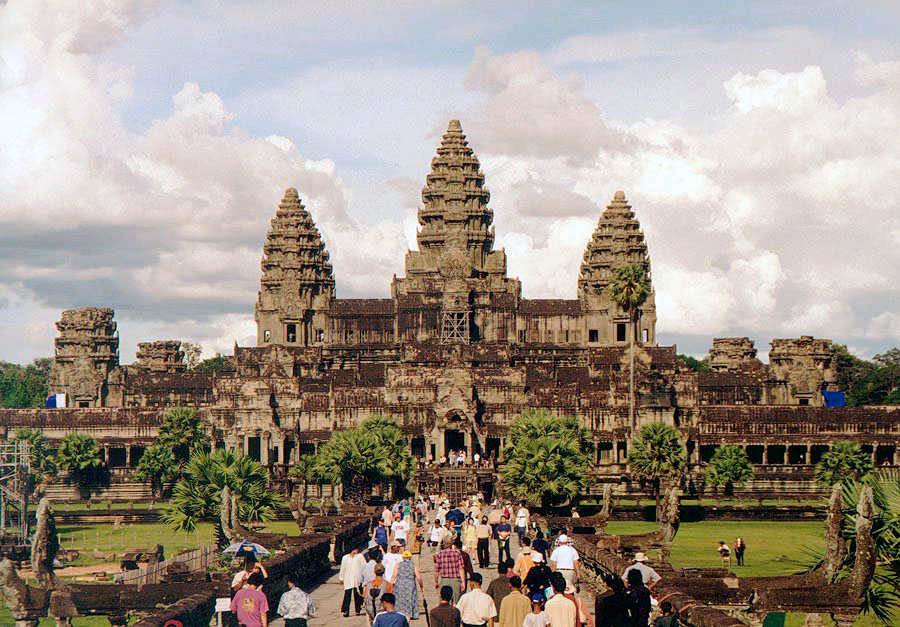
Angkor
Angkor (Khmer: អង្គរ [ʔɑŋkɔː], lit. 'capital city'), also known as Yasodharapura (Khmer: យសោធរបុរៈ; Sanskrit: यशोधरपुर), was the capital city of the Khmer Empire, located in present-day Cambodia. The city and empire flourished from approximately the 9th to the 15th centuries. The city houses the Angkor Wat, a temple complex that is one of Cambodia's most popular tourist attractions.
The name Angkor is derived from nokor (នគរ), a Khmer word meaning "kingdom" which in turn derived from Sanskrit nagara (नगर), meaning "city". The Angkorian period began in AD 802, when the Khmer Hindu monarch Jayavarman II declared himself a "universal monarch" and "god-king", and lasted until the late 14th century, first falling under Ayutthayan suzerainty in 1351. A Khmer rebellion against Siamese authority resulted in the 1431 sacking of Angkor by Ayutthaya, causing its population to migrate south to Longvek. The alternate name, Yasodharapura, was derived from the name of the foster mother of Lord Krishna in Hinduism. Hinduism was the largest religion in the ancient Khmer Empire, and many temples were constructed by Khmer kings dedicated to Hindu deities, including Angkor Wat.
The ruins of Angkor are located amid forests and farmland north of the Great Lake (Tonlé Sap) and south of the Kulen Hills, near modern-day Siem Reap city (13°24′N, 103°51′E), in Siem Reap Province. The temples of the Angkor area number over one thousand, ranging in scale from nondescript piles of brick rubble scattered through rice fields to the Angkor Wat, said to be the world's largest single religious monument. Many of the temples at Angkor have been restored, and together, they comprise the most significant site of Khmer architecture. Visitors approach two million annually, and the entire expanse, including Angkor Wat and Angkor Thom is collectively protected as a UNESCO World Heritage Site. The popularity of the site among tourists presents multiple challenges to the preservation of the ruins.
In 2007, an international team of researchers using satellite photographs and other modern techniques concluded that Angkor had been the largest pre-industrial city in the world by surface area, with an elaborate infrastructure system connecting an urban sprawl of at least 1,000 square kilometres (390 sq mi) to the well-known temples at its core. Angkor is considered to be a "hydraulic city" because it had a complicated water management network, which was used for systematically stabilizing, storing, and dispersing water throughout the area. This network is believed to have been used for irrigation in order to offset the unpredictable monsoon season and to also support the increasing population. Although the size of its population remains a topic of research and debate, newly identified agricultural systems in the Angkor area may have supported between 750,000 and one million people.
The Angkorian period may have begun shortly after 800 AD, when the Khmer King Jayavarman II announced the independence of Kambujadesa (Cambodia) from Java. According to Sdok Kok Thom inscription, circa 781 Indrapura was the first capital of Jayavarman II, located in Banteay Prei Nokor, near today's Kompong Cham. After he eventually returned to his home, the former kingdom of Chenla, he quickly built up his influence, conquered a series of competing kings, and in 790 became king of a kingdom called Kambuja by the Khmer. He then moved his court northwest to Mahendraparvata, in present day Kulen mountains, inland north from the great lake of Tonle Sap.
He also established the city of Hariharalaya (now known as Roluos) at the northern end of Tonlé Sap. Through a program of military campaigns, alliances, marriages and land grants, he achieved a unification of the country bordered by China to the north, Champa (now Central Vietnam) to the east, the ocean to the south and a place identified by a stone inscription as "the land of cardamoms and mangoes" to the west. In 802, Jayavarman articulated his new status by declaring himself "universal monarch" (chakravartin) and, in a move that was to be imitated by his successors and that linked him to the cult of Siva, taking on the epithet of "god-king" (devaraja). Before Jayavarman, Cambodia had consisted of a number of politically independent principalities collectively known to the Chinese by the names Funan and Chenla.
In 889, Yasovarman ascended to the throne. A great king and an accomplished builder, he was celebrated by one inscription as "a lion-man; he tore the enemy with the claws of his grandeur; his teeth were his policies; his eyes were the Veda." Near the old capital of Hariharalaya, Yasovarman constructed a new city, called Yasodharapura, centered on the hill and temple of Phnom Bakheng. In the tradition of his predecessors, he also constructed a massive reservoir called baray.
The significance of such reservoirs has been debated by modern scholars, some of whom have seen in them a means of irrigating rice fields, and others of whom have regarded them as religiously charged symbols of the great mythological oceans surrounding Mount Meru, the abode of the gods. The mountain, in turn, was represented by an elevated temple, in which the "god-king" was represented by a lingam. In accordance with this cosmic symbolism, Yasovarman built his central temple on a low hill known as Phnom Bakheng, surrounding it with a moat fed from the baray. He also built numerous other Hindu temples and ashrams, or retreats for ascetics.
Hub AI
Angkor AI simulator
(@Angkor_simulator)
Angkor
Angkor (Khmer: អង្គរ [ʔɑŋkɔː], lit. 'capital city'), also known as Yasodharapura (Khmer: យសោធរបុរៈ; Sanskrit: यशोधरपुर), was the capital city of the Khmer Empire, located in present-day Cambodia. The city and empire flourished from approximately the 9th to the 15th centuries. The city houses the Angkor Wat, a temple complex that is one of Cambodia's most popular tourist attractions.
The name Angkor is derived from nokor (នគរ), a Khmer word meaning "kingdom" which in turn derived from Sanskrit nagara (नगर), meaning "city". The Angkorian period began in AD 802, when the Khmer Hindu monarch Jayavarman II declared himself a "universal monarch" and "god-king", and lasted until the late 14th century, first falling under Ayutthayan suzerainty in 1351. A Khmer rebellion against Siamese authority resulted in the 1431 sacking of Angkor by Ayutthaya, causing its population to migrate south to Longvek. The alternate name, Yasodharapura, was derived from the name of the foster mother of Lord Krishna in Hinduism. Hinduism was the largest religion in the ancient Khmer Empire, and many temples were constructed by Khmer kings dedicated to Hindu deities, including Angkor Wat.
The ruins of Angkor are located amid forests and farmland north of the Great Lake (Tonlé Sap) and south of the Kulen Hills, near modern-day Siem Reap city (13°24′N, 103°51′E), in Siem Reap Province. The temples of the Angkor area number over one thousand, ranging in scale from nondescript piles of brick rubble scattered through rice fields to the Angkor Wat, said to be the world's largest single religious monument. Many of the temples at Angkor have been restored, and together, they comprise the most significant site of Khmer architecture. Visitors approach two million annually, and the entire expanse, including Angkor Wat and Angkor Thom is collectively protected as a UNESCO World Heritage Site. The popularity of the site among tourists presents multiple challenges to the preservation of the ruins.
In 2007, an international team of researchers using satellite photographs and other modern techniques concluded that Angkor had been the largest pre-industrial city in the world by surface area, with an elaborate infrastructure system connecting an urban sprawl of at least 1,000 square kilometres (390 sq mi) to the well-known temples at its core. Angkor is considered to be a "hydraulic city" because it had a complicated water management network, which was used for systematically stabilizing, storing, and dispersing water throughout the area. This network is believed to have been used for irrigation in order to offset the unpredictable monsoon season and to also support the increasing population. Although the size of its population remains a topic of research and debate, newly identified agricultural systems in the Angkor area may have supported between 750,000 and one million people.
The Angkorian period may have begun shortly after 800 AD, when the Khmer King Jayavarman II announced the independence of Kambujadesa (Cambodia) from Java. According to Sdok Kok Thom inscription, circa 781 Indrapura was the first capital of Jayavarman II, located in Banteay Prei Nokor, near today's Kompong Cham. After he eventually returned to his home, the former kingdom of Chenla, he quickly built up his influence, conquered a series of competing kings, and in 790 became king of a kingdom called Kambuja by the Khmer. He then moved his court northwest to Mahendraparvata, in present day Kulen mountains, inland north from the great lake of Tonle Sap.
He also established the city of Hariharalaya (now known as Roluos) at the northern end of Tonlé Sap. Through a program of military campaigns, alliances, marriages and land grants, he achieved a unification of the country bordered by China to the north, Champa (now Central Vietnam) to the east, the ocean to the south and a place identified by a stone inscription as "the land of cardamoms and mangoes" to the west. In 802, Jayavarman articulated his new status by declaring himself "universal monarch" (chakravartin) and, in a move that was to be imitated by his successors and that linked him to the cult of Siva, taking on the epithet of "god-king" (devaraja). Before Jayavarman, Cambodia had consisted of a number of politically independent principalities collectively known to the Chinese by the names Funan and Chenla.
In 889, Yasovarman ascended to the throne. A great king and an accomplished builder, he was celebrated by one inscription as "a lion-man; he tore the enemy with the claws of his grandeur; his teeth were his policies; his eyes were the Veda." Near the old capital of Hariharalaya, Yasovarman constructed a new city, called Yasodharapura, centered on the hill and temple of Phnom Bakheng. In the tradition of his predecessors, he also constructed a massive reservoir called baray.
The significance of such reservoirs has been debated by modern scholars, some of whom have seen in them a means of irrigating rice fields, and others of whom have regarded them as religiously charged symbols of the great mythological oceans surrounding Mount Meru, the abode of the gods. The mountain, in turn, was represented by an elevated temple, in which the "god-king" was represented by a lingam. In accordance with this cosmic symbolism, Yasovarman built his central temple on a low hill known as Phnom Bakheng, surrounding it with a moat fed from the baray. He also built numerous other Hindu temples and ashrams, or retreats for ascetics.