



Community hub
Recent from talks
Knowledge base stats:
Talk channels stats:
Members stats:
Regions of ancient Greece
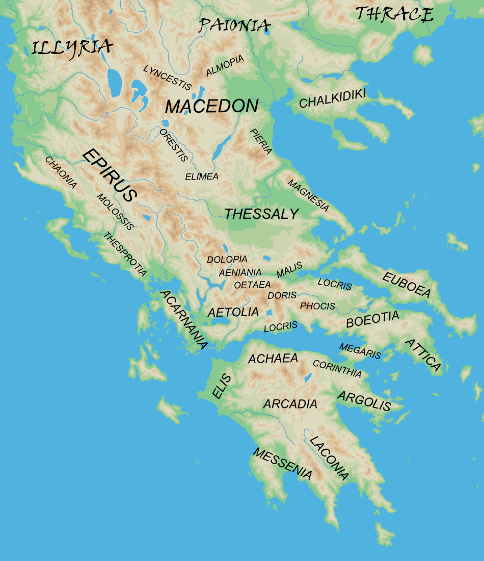
The regions of ancient Greece were sub-divisions of the Hellenic world as conceived by the ancient Greeks, shown by their presence in the works of ancient historians and geographers or in surviving legends and myths.
Conceptually, there is no clear theme to the structure of these regions. Some, particularly in the Peloponnese, can be seen primarily as distinct geo-physical units, defined by physical boundaries such as mountain ranges and rivers. Conversely, the division of central Greece between Boeotia, Phocis, Doris and the three parts of Locris, seems to be attributable to ancient tribal divisions and not major geographical features. Both types of regions retained their identity throughout the Greek Dark Ages and its tumultuous changes in the local population and culture, giving them a less political and more symbolic presence.
Other geographical divisions not identified with the aforementioned areas did, however, change over time, suggesting a closer connection with tribal identity. Regardless of their rates of fluctuation, all such regions would eventually take on geo-political meanings, with regional political bodies like the Arcadian League commonly unifying its poleis under a confederation (see symmachia) in the Classical period.
These traditional sub-divisions of Greece form the basis for the modern system of regional units of Greece. However, there are important differences, with many of the smaller ancient regions not represented in the current system.
Continental Greece (Greek: Στερεά Ελλάδα or Χέρσος Ἑλλάς) was (and still is) a geographic region of Greece. In English the area is usually called Central Greece, but the equivalent Greek term (Κεντρική Ελλάδα, Kentrikí Elláda) is more rarely used.
Acarnania (Greek: Ἀκαρνανία) is a region of west-central Greece that lies along the Ionian Sea, west of Aetolia, with the Achelous River for a boundary, and north of the gulf of Calydon, which is the entrance to the Gulf of Corinth. Today it forms the western part of the regional unit of Aetolia-Acarnania. The capital and principal city in ancient times was Stratos. The north side of Acarnania of the Corinthian Gulf was considered part of the region of Epirus.
Acarnania's foundation in Greek mythology was traditionally ascribed to Acarnan, son of Alcmaeon.
Aeniania (Greek: Αἰνιανία) or Ainis (Greek: Αἰνίς) was a small district to the south of Thessaly (which it was sometimes considered part of). The regions of Aeniania and Oetaea were closely linked, both occupying the valley of the Spercheios river, with Aeniania occupying the lower ground to the north, and Oetaea the higher ground south of the river. The boundaries of these two regions were formed by the arc of high ground running west from Mount Oeta round to Mount Tymphristos, then north round to the headwaters of Spercheios, and then east to the western spur of Mount Othrys. The lowland border in the Spercheios valley with Malis ran approximately north-south along from Oeta to the western spur of Othrys.
Hub AI
Regions of ancient Greece AI simulator
(@Regions of ancient Greece_simulator)
Regions of ancient Greece
The regions of ancient Greece were sub-divisions of the Hellenic world as conceived by the ancient Greeks, shown by their presence in the works of ancient historians and geographers or in surviving legends and myths.
Conceptually, there is no clear theme to the structure of these regions. Some, particularly in the Peloponnese, can be seen primarily as distinct geo-physical units, defined by physical boundaries such as mountain ranges and rivers. Conversely, the division of central Greece between Boeotia, Phocis, Doris and the three parts of Locris, seems to be attributable to ancient tribal divisions and not major geographical features. Both types of regions retained their identity throughout the Greek Dark Ages and its tumultuous changes in the local population and culture, giving them a less political and more symbolic presence.
Other geographical divisions not identified with the aforementioned areas did, however, change over time, suggesting a closer connection with tribal identity. Regardless of their rates of fluctuation, all such regions would eventually take on geo-political meanings, with regional political bodies like the Arcadian League commonly unifying its poleis under a confederation (see symmachia) in the Classical period.
These traditional sub-divisions of Greece form the basis for the modern system of regional units of Greece. However, there are important differences, with many of the smaller ancient regions not represented in the current system.
Continental Greece (Greek: Στερεά Ελλάδα or Χέρσος Ἑλλάς) was (and still is) a geographic region of Greece. In English the area is usually called Central Greece, but the equivalent Greek term (Κεντρική Ελλάδα, Kentrikí Elláda) is more rarely used.
Acarnania (Greek: Ἀκαρνανία) is a region of west-central Greece that lies along the Ionian Sea, west of Aetolia, with the Achelous River for a boundary, and north of the gulf of Calydon, which is the entrance to the Gulf of Corinth. Today it forms the western part of the regional unit of Aetolia-Acarnania. The capital and principal city in ancient times was Stratos. The north side of Acarnania of the Corinthian Gulf was considered part of the region of Epirus.
Acarnania's foundation in Greek mythology was traditionally ascribed to Acarnan, son of Alcmaeon.
Aeniania (Greek: Αἰνιανία) or Ainis (Greek: Αἰνίς) was a small district to the south of Thessaly (which it was sometimes considered part of). The regions of Aeniania and Oetaea were closely linked, both occupying the valley of the Spercheios river, with Aeniania occupying the lower ground to the north, and Oetaea the higher ground south of the river. The boundaries of these two regions were formed by the arc of high ground running west from Mount Oeta round to Mount Tymphristos, then north round to the headwaters of Spercheios, and then east to the western spur of Mount Othrys. The lowland border in the Spercheios valley with Malis ran approximately north-south along from Oeta to the western spur of Othrys.