Recent from talks
Bay Islands Department
Knowledge base stats:
Talk channels stats:
Members stats:
Bay Islands Department
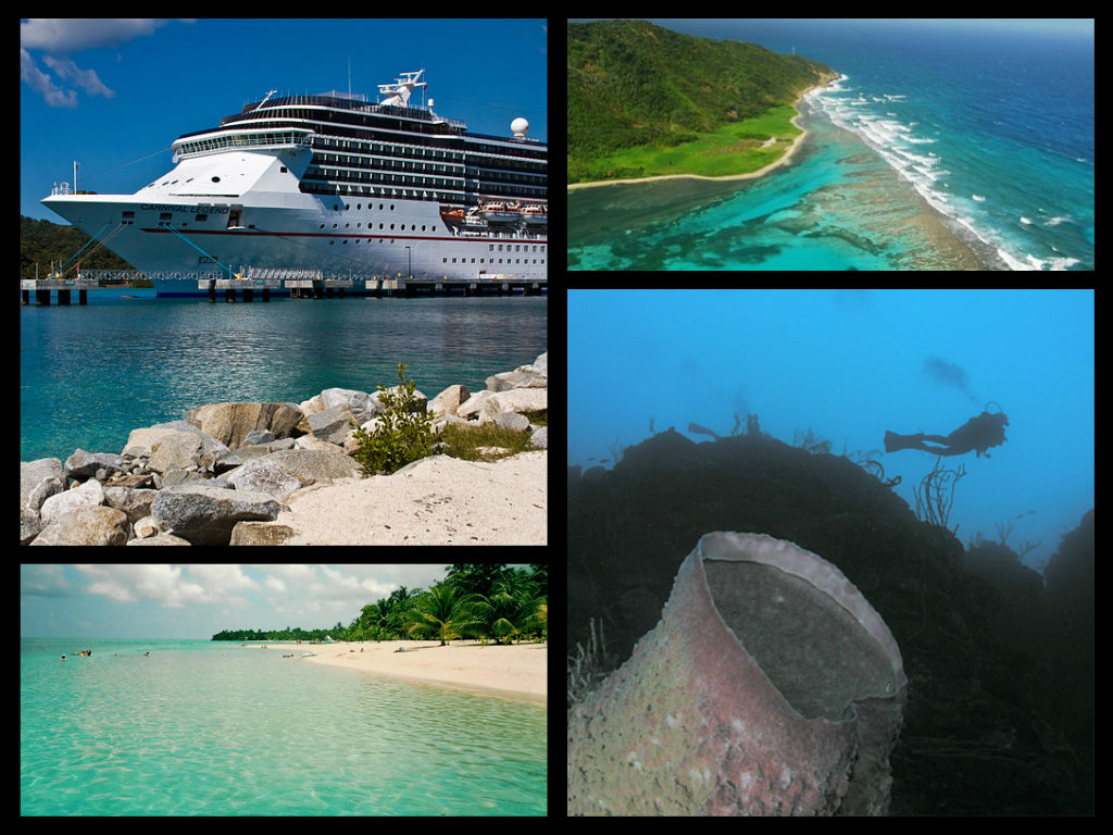
The Bay Islands (Spanish: Islas de la Bahía; pronounced [ˈislas de la βaˈi.a]) is a group of islands off the Caribbean coast of Honduras. Collectively, the islands form one of the 18 departments of Honduras. The departmental capital is Coxen Hole, on the island of Roatán.
The Bay Islands consist of eight islands and 53 small cays lying 15 kilometres (10 mi) to 60 kilometres (40 mi) off the northern coast of Honduras. These islands have been administered as a department of the Republic of Honduras since 1872. Located on the Caribbean Sea, not far east of the entrance to the Gulf of Honduras, they are clearly visible from the mountainous mainland.
The total surface area of the islands is 250 km2 (97 sq mi). In 2013, they had an estimated population of 71,500 people. The islands comprise three separate groups:
Roatán is the largest island, with a length of about 60 kilometres (40 mi) and a maximum width of 14 kilometres (9 mi) at its widest point. Roatán is characterized by its mountainous backbone, composed of hilltops that run west-to-east across the entire island. These hilltops are often crowned by outcrops of exposed metamorphic rocks such as marble, amphibolite, and serpentine. The island's southern coast has an abundance of deep ports and wide inlets, or 'bights', protected by reefs, while its northern coast is, save for a few narrow passages, largely inaccessible, due to extensive coral reef growth.
The island of Saint Helena has been described as a virtual extension of Roatán, since it is separated only by a long stretch of mangrove swamp. This island has a small elevated hill at its center, and is characterized by a large number of caves, most of which are located along a cliff on its western end.
Guanaja is the second largest island and is even more mountainous than Roatán. Geographically it features a series of hills, the highest of which rises to over 350 m above sea level, which is the highest elevation present in the Bay Islands. Alluvial plains characterize the areas between the hills.
Utila is third in size and is characterized by low mangrove swamps and a few small, low hills on its eastern end. The soils on this island are uncharacteristically fertile, perhaps owing to the islands's flat topography as well as volcanic tuffs and basalt lavas through coralline limestone.
Barbareta, Morat, and the Hog Islands are all small and rugged. Barbareta can be distinguished by the fact that it contains numerous hills, the tallest one reaching a height of 143 m (469 ft), above sea level. Approximately one-third of Barbareta is covered by serpentinite, making it the island with the largest deposit of serpentine among the Bay Islands. Morat, the smallest and flattest island, consists of just one ridge with two hills, which are composed mainly of sedimentary rocks, with some serpentinite intrusions.
Hub AI
Bay Islands Department AI simulator
(@Bay Islands Department_simulator)
Bay Islands Department
The Bay Islands (Spanish: Islas de la Bahía; pronounced [ˈislas de la βaˈi.a]) is a group of islands off the Caribbean coast of Honduras. Collectively, the islands form one of the 18 departments of Honduras. The departmental capital is Coxen Hole, on the island of Roatán.
The Bay Islands consist of eight islands and 53 small cays lying 15 kilometres (10 mi) to 60 kilometres (40 mi) off the northern coast of Honduras. These islands have been administered as a department of the Republic of Honduras since 1872. Located on the Caribbean Sea, not far east of the entrance to the Gulf of Honduras, they are clearly visible from the mountainous mainland.
The total surface area of the islands is 250 km2 (97 sq mi). In 2013, they had an estimated population of 71,500 people. The islands comprise three separate groups:
Roatán is the largest island, with a length of about 60 kilometres (40 mi) and a maximum width of 14 kilometres (9 mi) at its widest point. Roatán is characterized by its mountainous backbone, composed of hilltops that run west-to-east across the entire island. These hilltops are often crowned by outcrops of exposed metamorphic rocks such as marble, amphibolite, and serpentine. The island's southern coast has an abundance of deep ports and wide inlets, or 'bights', protected by reefs, while its northern coast is, save for a few narrow passages, largely inaccessible, due to extensive coral reef growth.
The island of Saint Helena has been described as a virtual extension of Roatán, since it is separated only by a long stretch of mangrove swamp. This island has a small elevated hill at its center, and is characterized by a large number of caves, most of which are located along a cliff on its western end.
Guanaja is the second largest island and is even more mountainous than Roatán. Geographically it features a series of hills, the highest of which rises to over 350 m above sea level, which is the highest elevation present in the Bay Islands. Alluvial plains characterize the areas between the hills.
Utila is third in size and is characterized by low mangrove swamps and a few small, low hills on its eastern end. The soils on this island are uncharacteristically fertile, perhaps owing to the islands's flat topography as well as volcanic tuffs and basalt lavas through coralline limestone.
Barbareta, Morat, and the Hog Islands are all small and rugged. Barbareta can be distinguished by the fact that it contains numerous hills, the tallest one reaching a height of 143 m (469 ft), above sea level. Approximately one-third of Barbareta is covered by serpentinite, making it the island with the largest deposit of serpentine among the Bay Islands. Morat, the smallest and flattest island, consists of just one ridge with two hills, which are composed mainly of sedimentary rocks, with some serpentinite intrusions.
Recent media