Recent from talks
Benbulbin
Knowledge base stats:
Talk channels stats:
Members stats:
Benbulbin
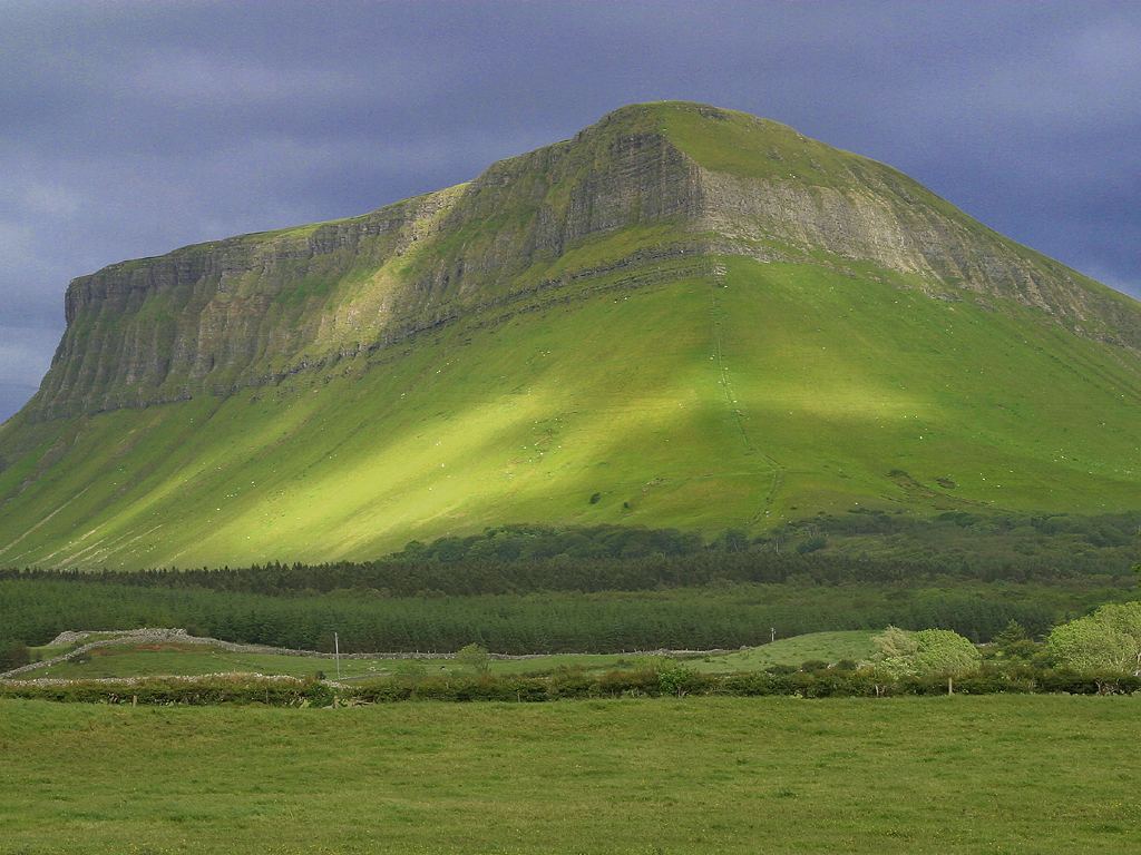
Benbulbin (Irish: Binn Ghulbain), sometimes Benbulben or Ben Bulben, is a steep-sided and flat-topped mountain in County Sligo, Ireland. It is part of the Dartry Mountains, in an area sometimes called "Yeats Country". Benbulbin, 526 m (1,726 ft) high, formed as a nunatak during the last Ice Age.
Benbulbin is a protected site, designated as a County Geological Site by Sligo County Council.
"Benbulbin", "Benbulben" and "Ben Bulben" are all anglicisations of the Irish name "Binn Ghulbain". "Binn" means "peak" or "mountain"; "ghulbain" may mean beak or jaw, or may refer to Conall Gulban, a son of Niall of the Nine Hostages, who was associated with the mountain.
Benbulbin was shaped during the ice age, when Ireland was under glaciers. Originally it was a large plateau. Glaciers moving from the northeast to southwest shaped it into its present distinct formation.
Benbulbin, and the Dartry Mountains as a whole, are composed of limestones on top of mudstones. These rocks formed in the area approximately 345-330 million years ago in the Viséan Stage of the Carboniferous Period. The environment was a shallow sea. Uppermost in the limestone layer is a thicker, harder limestone called the Dartry Limestone Formation. Below this is a thinner transitional limestone formation – the Glencar Limestone Formation. Further down, the lower slopes consist of shaly mudstone known as the Benbulben Shale Formation. Scree deposits are found near the base.
Fossils exist throughout the layers of the mountains. All layers have many fossilised sea shells. The shale layer also holds some corals.
Baryte was mined at Glencarbury near Benbulbin in the Dartry range between 1894 and 1979.
Benbulbin is an established walking destination. If climbed by the north face, it is a hazardous climb. That side bears the brunt of the high winds and storms that come in from the Atlantic Ocean. However, if approached by the south side, it is an easy walk, since that side slopes very gently. From the summit there are views over the coastal plain of north County Sligo and the Atlantic ocean. The land adjacent to the western edge of the ridge is privately owned farmland and not accessible to the general public. However, there is a paved path up the south face to the east near Glencar Waterfall just over the County Leitrim border.
Hub AI
Benbulbin AI simulator
(@Benbulbin_simulator)
Benbulbin
Benbulbin (Irish: Binn Ghulbain), sometimes Benbulben or Ben Bulben, is a steep-sided and flat-topped mountain in County Sligo, Ireland. It is part of the Dartry Mountains, in an area sometimes called "Yeats Country". Benbulbin, 526 m (1,726 ft) high, formed as a nunatak during the last Ice Age.
Benbulbin is a protected site, designated as a County Geological Site by Sligo County Council.
"Benbulbin", "Benbulben" and "Ben Bulben" are all anglicisations of the Irish name "Binn Ghulbain". "Binn" means "peak" or "mountain"; "ghulbain" may mean beak or jaw, or may refer to Conall Gulban, a son of Niall of the Nine Hostages, who was associated with the mountain.
Benbulbin was shaped during the ice age, when Ireland was under glaciers. Originally it was a large plateau. Glaciers moving from the northeast to southwest shaped it into its present distinct formation.
Benbulbin, and the Dartry Mountains as a whole, are composed of limestones on top of mudstones. These rocks formed in the area approximately 345-330 million years ago in the Viséan Stage of the Carboniferous Period. The environment was a shallow sea. Uppermost in the limestone layer is a thicker, harder limestone called the Dartry Limestone Formation. Below this is a thinner transitional limestone formation – the Glencar Limestone Formation. Further down, the lower slopes consist of shaly mudstone known as the Benbulben Shale Formation. Scree deposits are found near the base.
Fossils exist throughout the layers of the mountains. All layers have many fossilised sea shells. The shale layer also holds some corals.
Baryte was mined at Glencarbury near Benbulbin in the Dartry range between 1894 and 1979.
Benbulbin is an established walking destination. If climbed by the north face, it is a hazardous climb. That side bears the brunt of the high winds and storms that come in from the Atlantic Ocean. However, if approached by the south side, it is an easy walk, since that side slopes very gently. From the summit there are views over the coastal plain of north County Sligo and the Atlantic ocean. The land adjacent to the western edge of the ridge is privately owned farmland and not accessible to the general public. However, there is a paved path up the south face to the east near Glencar Waterfall just over the County Leitrim border.
Recent media