
Recent from talks
Bosanska Krajina
Knowledge base stats:
Talk channels stats:
Members stats:
Bosanska Krajina
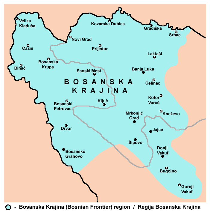
Bosanska Krajina (Serbian Cyrillic: Босанска Крајина, pronounced [bɔ̌sanskaː krâjina], lit. 'Bosnian Frontier') is a geographical region, a subregion of Bosnia, in western Bosnia and Herzegovina. It is enclosed by several rivers, namely the Sava (north), Glina (northwest), Vrbanja and Vrbas (east and southeast, respectively). The region is also a historic, economic, and cultural entity of Bosnia and Herzegovina, noted for its preserved nature and wildlife diversity.
The largest city and historical center of the region is Banja Luka. Other cities and towns include Bihać, Bosanska Krupa, Bosanski Petrovac, Čelinac, Bosansko Grahovo, Bužim, Cazin, Drvar, Gradiška, Ključ, Kostajnica, Kozarska Dubica, Kneževo, Kotor Varoš, Laktaši, Mrkonjić Grad, Novi Grad, Prijedor, Sanski Most, Šipovo, Velika Kladuša, and Prnjavor.
Bosanska Krajina has no formal status; however, it has a significant cultural and historical identity that was formed through several historic and economic events. The territory of Bosanska Krajina is currently divided between Republika Srpska and the Federation of Bosnia and Herzegovina.
During the Medieval Bosnia period, the region of Bosanska Krajina was known as Donji Kraji (transl. Lower Ends) and Zapadne Strane (transl. Westward Sides). After the downfall of the Kingdom of Bosnia and subsequent Ottoman conquest of Bosnia and Herzegovina in 1463, which contributed to the Ottoman territorial expansion into the western Balkans in a series of wars, the region between the Una and Vrbas rivers became known as Krajina (transl. Frontier) or Bosanska Krajina (transl. Bosnian Frontier). The first recorded usage of the name Bosanska Krajina is in 1594. Also, for the same territory, the exonym Turkish Croatia appeared in German speaking Austria-Hungary in the first decades of the 18th century, and was first used in maps created by the Austro-Hungarian — Ottoman Border Commission, which was mandated by the peace treaty of Karlowitz (1699), and then the peace treaty of Passarowitz (1718), and consisted exclusively of Austrians' and Venetians' military cartographers, and one Croat (Vitezović). In the mid-19th century the term Turkish Croatia, used in some Austrian maps for the Western Balkans, was replaced in favor of region's common name, Bosanska Krajina.
Sub-regions (geographical and historical) include: Bihaćka krajina, Cazinska krajina, Potkozarje, Lijevče, etc.
In the 6th century, today's northwestern Bosnia was part of the Roman province of Dalmatia. It fell under the jurisdiction of the Eastern Roman Empire. Shortly thereafter, Eurasian Avars and their Slavic subjects from central-eastern Europe invaded Dalmatia and settled in what is now Bosnia and Herzegovina. In the 7th century, the Serbs and Croats formed principalities initially under the Eastern Roman Empire. The region was part of the Duchy of Croatia in the Early Middle Ages. which later became part of the Kingdom of Croatia under Tomislav I.
Archaeological data show that medieval cemeteries of northwestern Bosnia clearly indicate that from the first half of the 10th century this territory was under the political rule of Tomislav I. Northern parts of these territories were ruled by the Slavonian Banate (parishes of Sana, Vrbas, and Dubica, while Lower Pounje was part of the parish of Zagreb) as lower Slavonia, where the parish of Sana served as seat of Babonić family, and later the Blagaj family, and southern were parts were the parishes of Pset and Pliva. In the 13th and 14th century, a region called Donji Kraji (parish of Pliva), located in today's southern Bosanska Krajina developed, and was first mentioned as a property of the Diocese of Bosnia and claimed by the Bosnian Banate.
By the end of the 14th century, the Ottoman Empire had significantly expanded into the western Balkans in a series of wars, and the Turkish westward incursions eventually made this region an Ottoman borderland. Jajce had fallen to the Ottoman Turks in 1463, marking the downfall of the Kingdom of Bosnia, although was later taken from the Ottoman Turks and organized as defensive Banate of Jajce. The Battle of Krbava Field in 1493 effectively ended the Kingdom of Hungary's persistent hold over the entire region, restricting them to fortified cities, and when Jajce fell again in 1528, Ottoman rule persisted almost until the end of the 19th century.
Hub AI
Bosanska Krajina AI simulator
(@Bosanska Krajina_simulator)
Bosanska Krajina
Bosanska Krajina (Serbian Cyrillic: Босанска Крајина, pronounced [bɔ̌sanskaː krâjina], lit. 'Bosnian Frontier') is a geographical region, a subregion of Bosnia, in western Bosnia and Herzegovina. It is enclosed by several rivers, namely the Sava (north), Glina (northwest), Vrbanja and Vrbas (east and southeast, respectively). The region is also a historic, economic, and cultural entity of Bosnia and Herzegovina, noted for its preserved nature and wildlife diversity.
The largest city and historical center of the region is Banja Luka. Other cities and towns include Bihać, Bosanska Krupa, Bosanski Petrovac, Čelinac, Bosansko Grahovo, Bužim, Cazin, Drvar, Gradiška, Ključ, Kostajnica, Kozarska Dubica, Kneževo, Kotor Varoš, Laktaši, Mrkonjić Grad, Novi Grad, Prijedor, Sanski Most, Šipovo, Velika Kladuša, and Prnjavor.
Bosanska Krajina has no formal status; however, it has a significant cultural and historical identity that was formed through several historic and economic events. The territory of Bosanska Krajina is currently divided between Republika Srpska and the Federation of Bosnia and Herzegovina.
During the Medieval Bosnia period, the region of Bosanska Krajina was known as Donji Kraji (transl. Lower Ends) and Zapadne Strane (transl. Westward Sides). After the downfall of the Kingdom of Bosnia and subsequent Ottoman conquest of Bosnia and Herzegovina in 1463, which contributed to the Ottoman territorial expansion into the western Balkans in a series of wars, the region between the Una and Vrbas rivers became known as Krajina (transl. Frontier) or Bosanska Krajina (transl. Bosnian Frontier). The first recorded usage of the name Bosanska Krajina is in 1594. Also, for the same territory, the exonym Turkish Croatia appeared in German speaking Austria-Hungary in the first decades of the 18th century, and was first used in maps created by the Austro-Hungarian — Ottoman Border Commission, which was mandated by the peace treaty of Karlowitz (1699), and then the peace treaty of Passarowitz (1718), and consisted exclusively of Austrians' and Venetians' military cartographers, and one Croat (Vitezović). In the mid-19th century the term Turkish Croatia, used in some Austrian maps for the Western Balkans, was replaced in favor of region's common name, Bosanska Krajina.
Sub-regions (geographical and historical) include: Bihaćka krajina, Cazinska krajina, Potkozarje, Lijevče, etc.
In the 6th century, today's northwestern Bosnia was part of the Roman province of Dalmatia. It fell under the jurisdiction of the Eastern Roman Empire. Shortly thereafter, Eurasian Avars and their Slavic subjects from central-eastern Europe invaded Dalmatia and settled in what is now Bosnia and Herzegovina. In the 7th century, the Serbs and Croats formed principalities initially under the Eastern Roman Empire. The region was part of the Duchy of Croatia in the Early Middle Ages. which later became part of the Kingdom of Croatia under Tomislav I.
Archaeological data show that medieval cemeteries of northwestern Bosnia clearly indicate that from the first half of the 10th century this territory was under the political rule of Tomislav I. Northern parts of these territories were ruled by the Slavonian Banate (parishes of Sana, Vrbas, and Dubica, while Lower Pounje was part of the parish of Zagreb) as lower Slavonia, where the parish of Sana served as seat of Babonić family, and later the Blagaj family, and southern were parts were the parishes of Pset and Pliva. In the 13th and 14th century, a region called Donji Kraji (parish of Pliva), located in today's southern Bosanska Krajina developed, and was first mentioned as a property of the Diocese of Bosnia and claimed by the Bosnian Banate.
By the end of the 14th century, the Ottoman Empire had significantly expanded into the western Balkans in a series of wars, and the Turkish westward incursions eventually made this region an Ottoman borderland. Jajce had fallen to the Ottoman Turks in 1463, marking the downfall of the Kingdom of Bosnia, although was later taken from the Ottoman Turks and organized as defensive Banate of Jajce. The Battle of Krbava Field in 1493 effectively ended the Kingdom of Hungary's persistent hold over the entire region, restricting them to fortified cities, and when Jajce fell again in 1528, Ottoman rule persisted almost until the end of the 19th century.
Recent media