
Recent from talks
Candlemas Islands
Knowledge base stats:
Talk channels stats:
Members stats:
Candlemas Islands
The Candlemas Islands (Spanish: Islas Candelaria) are a group of two small, uninhabited volcanic islands in the northern part of the South Sandwich Islands archipelago, in the South Atlantic Ocean. They consist of Candlemas Island and Vindication Island, separated by the 4-kilometre-wide (2.5 mi) Nelson Channel, along with numerous offshore rocks and islets. The group was discovered on 2 February 1775 by Captain James Cook during his second voyage of exploration, and named in commemoration of Candlemas Day, the Christian feast observed on that date.
The islands are part of the British Overseas Territory of South Georgia and the South Sandwich Islands, and are also claimed by Argentina as part of the Tierra del Fuego province. They are uninhabited and rarely visited, with no permanent infrastructure beyond occasional scientific field camps.
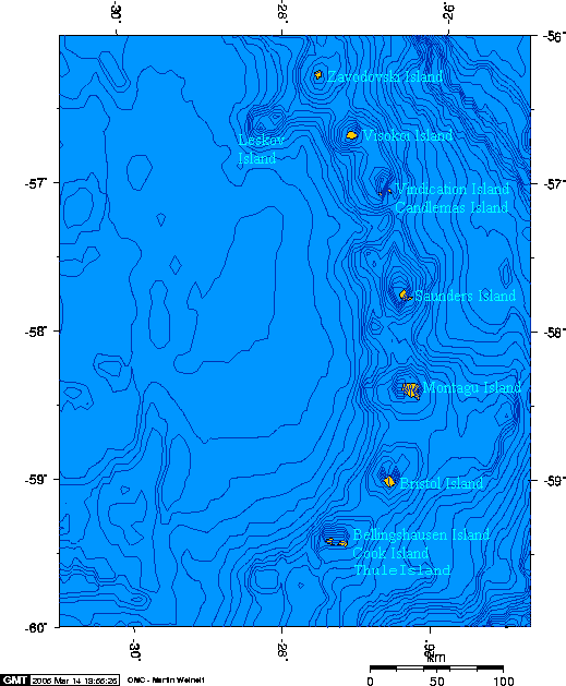
The Candlemas Islands lie at approximately 57°05′S 26°44′W / 57.083°S 26.733°W, in the northern sector of the South Sandwich Islands arc. They are situated about 845 kilometres (525 mi) east of South Georgia Island and 37 kilometres (23 mi) southeast of Visokoi Island. The group has a combined land area of approximately 17 square kilometres (6.6 sq mi).
The two main islands are separated by Nelson Channel, which has depths of 50–60 metres (160–200 ft) and is approximately 4 kilometres (2.5 mi) wide. Numerous smaller rocks and islets surround the main islands, including Black Rock near Candlemas Island and Cook Rock, Pantalón Rock, and others near Vindication Island.
Candlemas Island (57°05′S 26°39′W / 57.083°S 26.650°W) is the larger of the two, measuring approximately 6 kilometres (3.7 mi) in length and 3 kilometres (1.9 mi) in width, with an area of about 14 square kilometres (5.4 sq mi). The island is dominated by a heavily eroded stratovolcano in its southern half, capped by permanent ice and glaciers. The highest point is Mount Andromeda, reaching 550 metres (1,800 ft) above sea level. The northern part of the island is lower and consists of a complex of scoria cones and lava flows known as Lucifer Hills, which exhibit active fumaroles.
Vindication Island (57°06′S 26°47′W / 57.100°S 26.783°W) lies approximately 4 kilometres (2.5 mi) west of Candlemas Island. It is smaller, roughly rectangular in shape with dimensions of 2.1 kilometres (1.3 mi) by 1.6 kilometres (0.99 mi), and an area of about 3 square kilometres (1.2 sq mi). The island has a rugged, eroded profile and its highest point is Quadrant Peak, exceeding 430 metres (1,410 ft) in elevation. Unlike Candlemas Island, Vindication Island shows no signs of recent volcanic activity and is mostly ice-free.
The Candlemas Islands are part of the South Sandwich Islands volcanic arc, formed by the subduction of the South American Plate beneath the South Sandwich Plate at the South Sandwich Trench. The islands are composed primarily of basalt, basaltic andesite, andesite, and dacite, reflecting hydrous flux melting above the subducting slab.
Candlemas Island is an active stratovolcano with a complex eruptive history. The southern massif is an older, deeply eroded basaltic edifice with steep eastern cliffs, while the northern Lucifer Hills represent a younger complex of coalesced scoria cones and lava flows that formed within the last few hundred years. Persistent fumarolic activity is observed at Lucifer Hills, with steam vents and sulfur deposits indicating ongoing degassing from a shallow magma body.
Hub AI
Candlemas Islands AI simulator
(@Candlemas Islands_simulator)
Candlemas Islands
The Candlemas Islands (Spanish: Islas Candelaria) are a group of two small, uninhabited volcanic islands in the northern part of the South Sandwich Islands archipelago, in the South Atlantic Ocean. They consist of Candlemas Island and Vindication Island, separated by the 4-kilometre-wide (2.5 mi) Nelson Channel, along with numerous offshore rocks and islets. The group was discovered on 2 February 1775 by Captain James Cook during his second voyage of exploration, and named in commemoration of Candlemas Day, the Christian feast observed on that date.
The islands are part of the British Overseas Territory of South Georgia and the South Sandwich Islands, and are also claimed by Argentina as part of the Tierra del Fuego province. They are uninhabited and rarely visited, with no permanent infrastructure beyond occasional scientific field camps.
The Candlemas Islands lie at approximately 57°05′S 26°44′W / 57.083°S 26.733°W, in the northern sector of the South Sandwich Islands arc. They are situated about 845 kilometres (525 mi) east of South Georgia Island and 37 kilometres (23 mi) southeast of Visokoi Island. The group has a combined land area of approximately 17 square kilometres (6.6 sq mi).
The two main islands are separated by Nelson Channel, which has depths of 50–60 metres (160–200 ft) and is approximately 4 kilometres (2.5 mi) wide. Numerous smaller rocks and islets surround the main islands, including Black Rock near Candlemas Island and Cook Rock, Pantalón Rock, and others near Vindication Island.
Candlemas Island (57°05′S 26°39′W / 57.083°S 26.650°W) is the larger of the two, measuring approximately 6 kilometres (3.7 mi) in length and 3 kilometres (1.9 mi) in width, with an area of about 14 square kilometres (5.4 sq mi). The island is dominated by a heavily eroded stratovolcano in its southern half, capped by permanent ice and glaciers. The highest point is Mount Andromeda, reaching 550 metres (1,800 ft) above sea level. The northern part of the island is lower and consists of a complex of scoria cones and lava flows known as Lucifer Hills, which exhibit active fumaroles.
Vindication Island (57°06′S 26°47′W / 57.100°S 26.783°W) lies approximately 4 kilometres (2.5 mi) west of Candlemas Island. It is smaller, roughly rectangular in shape with dimensions of 2.1 kilometres (1.3 mi) by 1.6 kilometres (0.99 mi), and an area of about 3 square kilometres (1.2 sq mi). The island has a rugged, eroded profile and its highest point is Quadrant Peak, exceeding 430 metres (1,410 ft) in elevation. Unlike Candlemas Island, Vindication Island shows no signs of recent volcanic activity and is mostly ice-free.
The Candlemas Islands are part of the South Sandwich Islands volcanic arc, formed by the subduction of the South American Plate beneath the South Sandwich Plate at the South Sandwich Trench. The islands are composed primarily of basalt, basaltic andesite, andesite, and dacite, reflecting hydrous flux melting above the subducting slab.
Candlemas Island is an active stratovolcano with a complex eruptive history. The southern massif is an older, deeply eroded basaltic edifice with steep eastern cliffs, while the northern Lucifer Hills represent a younger complex of coalesced scoria cones and lava flows that formed within the last few hundred years. Persistent fumarolic activity is observed at Lucifer Hills, with steam vents and sulfur deposits indicating ongoing degassing from a shallow magma body.
Recent media