
Recent from talks
Carrauntoohil
Knowledge base stats:
Talk channels stats:
Members stats:
Carrauntoohil
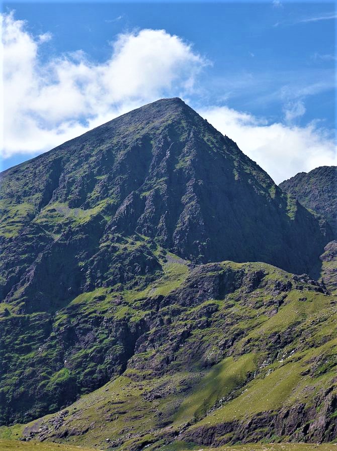
Carrauntoohil, Carrauntoohill or Carrantuohill (/ˌkær.ən.ˈtuː.əl/, KARR-ən-TOO-əl; Irish: Corrán Tuathail [ˌkɔɾˠaːn̪ˠ ˈt̪ˠuəhəlʲ], meaning "Tuathal's sickle") is the highest mountain in Ireland at 1,038.6 metres (3,407 feet 6 inches). It is on the Iveragh Peninsula in County Kerry, close to the centre of Ireland's highest mountain range, MacGillycuddy's Reeks. Carrauntoohil is composed mainly of sandstone, whose glaciation produced distinctive features on the mountain such as the Eagle's Nest corrie and some deep gullies and sharp arêtes in its east and northeastern faces that are popular with rock and winter climbers.
As Ireland's highest mountain, Carrauntoohil is popular with mountain walkers, who most commonly ascend via the Devil's Ladder route; however, Carrauntoohil is also climbed as part of longer mountain walking routes in the MacGillycuddy's Reeks range, including the 15-kilometre (9+1⁄2 mi) Coomloughra Horseshoe or the 26-kilometre (16 mi) MacGillycuddy's Reeks Ridge Walk of the entire mountain range. Carrauntoohil, and most of the range is held in private ownership and is not part of any Irish national park; however, reasonable access is granted to the public for recreational use.
Carrauntoohil is composed of sandstone particles of various sizes which are collectively known as Old Red Sandstone. Old Red Sandstone has a purple-reddish colour (stained green in places), and has virtually no fossils; it dates from the Devonian period (410 to 350 million years ago) when Ireland was in a hot equatorial climate. The sedimentary rocks of the Iveragh Peninsula are composed of three layers that are up to 7 kilometres (4+1⁄2 mi) thick (in ascending order): Lough Acoose Formation, Chloritic Sandstone Formation, and the Ballinskelligs Sandstone Formation.
Carrauntoohil was later subject to significant glaciation during the last ice age, the result of which is deep fracturing of the rock, and the surrounding of Carrauntoohil by U-shaped valleys, sharp arêtes, and deep corries.
Carrauntoohil is the central peak of the MacGillycuddy's Reeks range, and has three major ridges. A narrow rocky ridge, or arête, to the north, known as the Beenkeragh Ridge, contains the summit of The Bones (Na Cnámha), and leads to Ireland's second-highest peak, Beenkeragh (Binn Chaorach) at 1,008 m (3,307 ft). The ridge westward, called the Caher Ridge, also an arête, leads to Ireland's third-highest peak, Caher at 1,000 m (3,300 ft). A third and much wider unnamed south-easterly ridge, or spur, leads down to a col where sits the top of the Devil's Ladder (the classic access route for Carrauntoohil from the Hag's Glen), but then rises back up to Cnoc na Toinne 845 m (2,772 ft), from which the long easterly ridge section of MacGillycuddy's Reeks is accessed.
Carrauntoohil overlooks three U-shaped valleys, each of which containing their own lakes. To the east of Carrauntoohil is the Hag's Glen (Irish: Com Caillí, lit. 'hollow of the Cailleach'), to the west is Coomloughra (Irish: Chom Luachra, lit. 'hollow of the rushes'), and to the south is Curragh More (Irish: Currach Mór, lit. 'great marsh').
Carrauntoohil has a deep corrie, known as the Eagle's Nest, at its north-east face, which is accessed from the Hag's Glen, and rises up through three levels. At the top, the third level, is Lough Cummeenoughter, Ireland's highest lake. The Eagle's Nest gives views of the gullies on Carrauntoohil's north-east face: Curved Gully, Central Gully, and Brother O'Shea's Gully. Sometimes the term Eagle's Nest is used to refer to the small stone Mountain Rescue Hut that sits on the first level of the corrie, where the Heavenly Gates descent gully meets the Eagle's Nest corrie.
Carrauntoohil is the highest mountain in Ireland on all classification scales. It is the 133rd-highest mountain, and 4th most prominent mountain, in Britain and Ireland, on the Simms classification. Carrauntoohil is regarded by the Scottish Mountaineering Club (SMC) as one of 34 Furths, which are defined as mountains above 3,000 feet (914.4 m) in elevation and meeting the SMC criteria for a Munro (i.e. "sufficient separation"), and which are outside (or furth), of Scotland; this is why Carrauntoohil is also referred to as one of the thirteen Irish Munros.
Hub AI
Carrauntoohil AI simulator
(@Carrauntoohil_simulator)
Carrauntoohil
Carrauntoohil, Carrauntoohill or Carrantuohill (/ˌkær.ən.ˈtuː.əl/, KARR-ən-TOO-əl; Irish: Corrán Tuathail [ˌkɔɾˠaːn̪ˠ ˈt̪ˠuəhəlʲ], meaning "Tuathal's sickle") is the highest mountain in Ireland at 1,038.6 metres (3,407 feet 6 inches). It is on the Iveragh Peninsula in County Kerry, close to the centre of Ireland's highest mountain range, MacGillycuddy's Reeks. Carrauntoohil is composed mainly of sandstone, whose glaciation produced distinctive features on the mountain such as the Eagle's Nest corrie and some deep gullies and sharp arêtes in its east and northeastern faces that are popular with rock and winter climbers.
As Ireland's highest mountain, Carrauntoohil is popular with mountain walkers, who most commonly ascend via the Devil's Ladder route; however, Carrauntoohil is also climbed as part of longer mountain walking routes in the MacGillycuddy's Reeks range, including the 15-kilometre (9+1⁄2 mi) Coomloughra Horseshoe or the 26-kilometre (16 mi) MacGillycuddy's Reeks Ridge Walk of the entire mountain range. Carrauntoohil, and most of the range is held in private ownership and is not part of any Irish national park; however, reasonable access is granted to the public for recreational use.
Carrauntoohil is composed of sandstone particles of various sizes which are collectively known as Old Red Sandstone. Old Red Sandstone has a purple-reddish colour (stained green in places), and has virtually no fossils; it dates from the Devonian period (410 to 350 million years ago) when Ireland was in a hot equatorial climate. The sedimentary rocks of the Iveragh Peninsula are composed of three layers that are up to 7 kilometres (4+1⁄2 mi) thick (in ascending order): Lough Acoose Formation, Chloritic Sandstone Formation, and the Ballinskelligs Sandstone Formation.
Carrauntoohil was later subject to significant glaciation during the last ice age, the result of which is deep fracturing of the rock, and the surrounding of Carrauntoohil by U-shaped valleys, sharp arêtes, and deep corries.
Carrauntoohil is the central peak of the MacGillycuddy's Reeks range, and has three major ridges. A narrow rocky ridge, or arête, to the north, known as the Beenkeragh Ridge, contains the summit of The Bones (Na Cnámha), and leads to Ireland's second-highest peak, Beenkeragh (Binn Chaorach) at 1,008 m (3,307 ft). The ridge westward, called the Caher Ridge, also an arête, leads to Ireland's third-highest peak, Caher at 1,000 m (3,300 ft). A third and much wider unnamed south-easterly ridge, or spur, leads down to a col where sits the top of the Devil's Ladder (the classic access route for Carrauntoohil from the Hag's Glen), but then rises back up to Cnoc na Toinne 845 m (2,772 ft), from which the long easterly ridge section of MacGillycuddy's Reeks is accessed.
Carrauntoohil overlooks three U-shaped valleys, each of which containing their own lakes. To the east of Carrauntoohil is the Hag's Glen (Irish: Com Caillí, lit. 'hollow of the Cailleach'), to the west is Coomloughra (Irish: Chom Luachra, lit. 'hollow of the rushes'), and to the south is Curragh More (Irish: Currach Mór, lit. 'great marsh').
Carrauntoohil has a deep corrie, known as the Eagle's Nest, at its north-east face, which is accessed from the Hag's Glen, and rises up through three levels. At the top, the third level, is Lough Cummeenoughter, Ireland's highest lake. The Eagle's Nest gives views of the gullies on Carrauntoohil's north-east face: Curved Gully, Central Gully, and Brother O'Shea's Gully. Sometimes the term Eagle's Nest is used to refer to the small stone Mountain Rescue Hut that sits on the first level of the corrie, where the Heavenly Gates descent gully meets the Eagle's Nest corrie.
Carrauntoohil is the highest mountain in Ireland on all classification scales. It is the 133rd-highest mountain, and 4th most prominent mountain, in Britain and Ireland, on the Simms classification. Carrauntoohil is regarded by the Scottish Mountaineering Club (SMC) as one of 34 Furths, which are defined as mountains above 3,000 feet (914.4 m) in elevation and meeting the SMC criteria for a Munro (i.e. "sufficient separation"), and which are outside (or furth), of Scotland; this is why Carrauntoohil is also referred to as one of the thirteen Irish Munros.
Recent media