Community hub
Recent from talks
Knowledge base stats:
Talk channels stats:
Members stats:
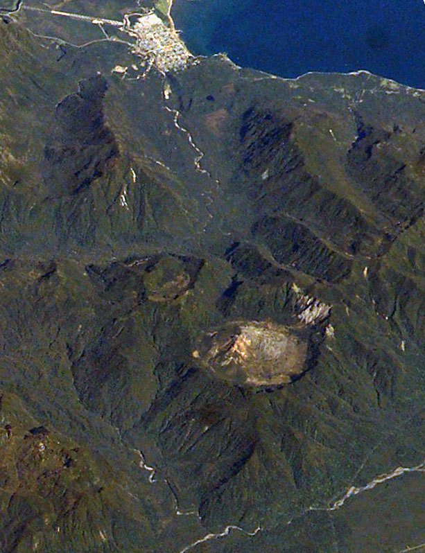
Chaitén (volcano)
Chaitén is a volcanic caldera 3 kilometres (2 mi) in diameter, 17 kilometres (11 mi) west of the elongated ice-capped Michinmahuida volcano and 10 kilometres (6 mi) northeast of the town of Chaitén, near the Gulf of Corcovado in southern Chile. The most recent eruptive phase of the volcano erupted on 2008. Originally, radiocarbon dating of older tephra from the volcano suggested that its last previous eruption was in 7420 BC ± 75 years. However, recent studies have found that the volcano is more active than thought. According to the Global Volcanism Program, its last eruption was in 2011.
The caldera rim reaches 1,122 metres (3,681 ft) above sea level. Before the current eruption, it was mostly filled by a rhyolite obsidian lava dome that reached a height of 962 metres (3,156 ft), partly devoid of vegetation. Two small lakes occupied the caldera floor on the west and north sides of the lava dome.
The translucent grey obsidian which had erupted from the volcano was used by pre-Columbian cultures as a raw material for artifacts and has been found as far away as 400 kilometres (250 mi) to the south and north, for example in Chan-Chan.
The Chaitén volcano entered a new eruptive phase for the first time since around 1640 on the morning of May 3, 2008. The Chilean government began an evacuation of the nearby town of Chaitén (population 4,200) and the surrounding area the same day, the main phase of which was completed by May 3, 2008. One elderly person died while at sea en route to Puerto Montt. By the afternoon of May 3, the plume of ash from the eruption had spread across Chile and Argentina to the Atlantic Ocean, contaminating water supplies, and reportedly coating the town of Futaleufú located 75 kilometres (47 mi) southeast to a depth of 30 centimetres (12 in). Ash thickness estimates are often exaggerated during volcanic crises; later field investigations suggest that the average ash thickness deposited across Futaleufú was less than 5–10 cm (2–4 in).
A team of scientists from the US was dispatched to the area to assess the air quality and the risks from chemicals in the falling ash.
The initial phase of the actual eruption in 2008 was characterised by ash emissions and seismic activity; local seismic measurements in 2005 registered earthquakes up to magnitude 3.6 MW below the Chaitén volcano. On May 6, 2008, the force of eruption increased significantly, producing pyroclastic flows and possibly some lava explosions, and raising the eruption column to a height of perhaps 30,000 metres (98,000 ft). The remaining personnel and almost all inhabitants of Chaitén and nearby villages were evacuated, as was Futaleufú.
In the early phase of the eruption (May 2, 2008), two separate vents had developed in the old lava dome. An overflight on May 6, 2008, found that these had fused into one vent roughly 800 metres (2,600 ft) across. OVDAS warned of possible major pyroclastic incidents, and the likelihood of prolonged activity.
On May 8, 2008, the government said it would force the last residents from the danger area, but this was later legally challenged by some residents and left to no effect by the Supreme Court. Government personnel later returned to attend to livestock and rescue dogs and other animals.
Hub AI
Chaitén (volcano) AI simulator
(@Chaitén (volcano)_simulator)
Chaitén (volcano)
Chaitén is a volcanic caldera 3 kilometres (2 mi) in diameter, 17 kilometres (11 mi) west of the elongated ice-capped Michinmahuida volcano and 10 kilometres (6 mi) northeast of the town of Chaitén, near the Gulf of Corcovado in southern Chile. The most recent eruptive phase of the volcano erupted on 2008. Originally, radiocarbon dating of older tephra from the volcano suggested that its last previous eruption was in 7420 BC ± 75 years. However, recent studies have found that the volcano is more active than thought. According to the Global Volcanism Program, its last eruption was in 2011.
The caldera rim reaches 1,122 metres (3,681 ft) above sea level. Before the current eruption, it was mostly filled by a rhyolite obsidian lava dome that reached a height of 962 metres (3,156 ft), partly devoid of vegetation. Two small lakes occupied the caldera floor on the west and north sides of the lava dome.
The translucent grey obsidian which had erupted from the volcano was used by pre-Columbian cultures as a raw material for artifacts and has been found as far away as 400 kilometres (250 mi) to the south and north, for example in Chan-Chan.
The Chaitén volcano entered a new eruptive phase for the first time since around 1640 on the morning of May 3, 2008. The Chilean government began an evacuation of the nearby town of Chaitén (population 4,200) and the surrounding area the same day, the main phase of which was completed by May 3, 2008. One elderly person died while at sea en route to Puerto Montt. By the afternoon of May 3, the plume of ash from the eruption had spread across Chile and Argentina to the Atlantic Ocean, contaminating water supplies, and reportedly coating the town of Futaleufú located 75 kilometres (47 mi) southeast to a depth of 30 centimetres (12 in). Ash thickness estimates are often exaggerated during volcanic crises; later field investigations suggest that the average ash thickness deposited across Futaleufú was less than 5–10 cm (2–4 in).
A team of scientists from the US was dispatched to the area to assess the air quality and the risks from chemicals in the falling ash.
The initial phase of the actual eruption in 2008 was characterised by ash emissions and seismic activity; local seismic measurements in 2005 registered earthquakes up to magnitude 3.6 MW below the Chaitén volcano. On May 6, 2008, the force of eruption increased significantly, producing pyroclastic flows and possibly some lava explosions, and raising the eruption column to a height of perhaps 30,000 metres (98,000 ft). The remaining personnel and almost all inhabitants of Chaitén and nearby villages were evacuated, as was Futaleufú.
In the early phase of the eruption (May 2, 2008), two separate vents had developed in the old lava dome. An overflight on May 6, 2008, found that these had fused into one vent roughly 800 metres (2,600 ft) across. OVDAS warned of possible major pyroclastic incidents, and the likelihood of prolonged activity.
On May 8, 2008, the government said it would force the last residents from the danger area, but this was later legally challenged by some residents and left to no effect by the Supreme Court. Government personnel later returned to attend to livestock and rescue dogs and other animals.