Recent from talks
Chesapeake Bay
Knowledge base stats:
Talk channels stats:
Members stats:
Chesapeake Bay
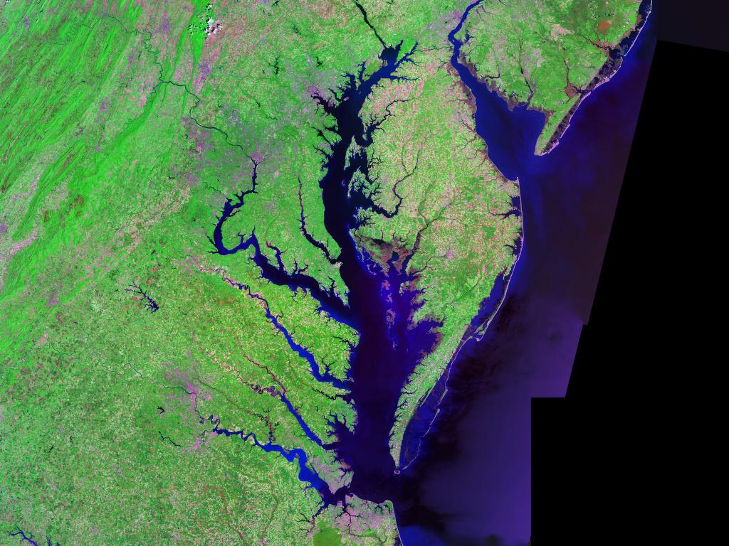
The Chesapeake Bay (/ˈtʃɛsəpiːk/ CHESS-ə-peek) is the largest estuary in the United States. The bay is located in the Mid-Atlantic region and is primarily separated from the Atlantic Ocean by the Delmarva Peninsula, including parts of the Eastern Shore of Maryland, the Eastern Shore of Virginia, and the state of Delaware. The mouth of the bay at its southern point is located between Cape Henry and Cape Charles. With its northern portion in Maryland and the southern part in Virginia, the Chesapeake Bay is a very important feature for the ecology and economy of those two states, as well as others surrounding within its watershed. More than 150 major rivers and streams flow into the bay's 64,299-square-mile (166,534 km2) drainage basin, which covers parts of six states (New York, Pennsylvania, Delaware, Maryland, Virginia, and West Virginia) and all of Washington, D.C.
The bay is approximately 200 miles (320 km) long from its northern headwaters in the Susquehanna River to its outlet in the Atlantic Ocean. It is 2.8 miles (4.5 km) wide at its narrowest (between Kent County's Plum Point near Newtown in the east and the Harford County western shore near Romney Creek) and 30 miles (48 km) at its widest (just south of the mouth of the Potomac River, which divides Maryland from Virginia). Total shoreline including tributaries is 11,684 miles (18,804 km), circumnavigating a surface area of 4,479 square miles (11,601 km2). Average depth is 21 feet (6.4 m), reaching a maximum of 174 feet (53 m). The bay is spanned twice, in Maryland by the Chesapeake Bay Bridge from Sandy Point (near Annapolis) to Kent Island and in Virginia by the Chesapeake Bay Bridge–Tunnel connecting Virginia Beach to Cape Charles.
Known for both its beauty and bounty, the bay has become "emptier", with fewer crabs, oysters and watermen (fishermen) since the mid-20th century. Nutrient pollution and urban runoff have been identified as major components of impaired water quality in the bay, stressing ecosystems and compounding the decline of shellfish due to overharvesting. Restoration efforts that began in the 1990s have continued into the 21st century and show potential for growth of the native oyster population. The health of the Chesapeake Bay improved in 2015, marking three years of gains over a four-year period. Slight improvements in water quality were observed in 2021, compared to indicators measured in 2020. The bay is experiencing other environmental concerns, including climate change, which is causing sea level rise that erodes coastal areas and infrastructure and changes the marine ecosystem.
The word Chesepiooc is an Algonquian word referring to a village 'at a big river'. It is the seventh-oldest surviving English placename in the United States, first applied as Chesepiook by explorers heading north from the Roanoke Colony into a Chesapeake tributary in 1585 or 1586. The name may also refer to the Chesapeake people or the Chesepian, a Native American tribe who inhabited the area now known as South Hampton Roads in the U.S. state of Virginia. They occupied an area that is now the Norfolk, Portsmouth, Chesapeake, and Virginia Beach areas. In 2005, Algonquian linguist Blair Rudes "helped to dispel one of the area's most widely held beliefs: that 'Chesapeake' means something like 'great shellfish bay'. It does not, Rudes said. The name might have actually meant something like 'great water', or it might have just referred to a village location at the bay's mouth."
The first European name for the bay was "Bahia de Santa Maria" (St. Mary's bay). This name was coined by the Spanish.
The Chesapeake Bay is an estuary to the North Atlantic, lying between the Delmarva Peninsula to the east and the North American mainland to the west. It is the ria, or drowned valley, of the Susquehanna River, meaning that it was the alluvial plain where the river flowed when the sea level was lower. It is not a fjord, because the Laurentide Ice Sheet never reached as far south as the northernmost point on the bay. North of Baltimore, the western shore borders the hilly Piedmont region of Maryland; south of the city the bay lies within the state's low-lying coastal plain, with sedimentary cliffs to the west, and flat islands, winding creeks and marshes to the east. The large rivers entering the bay from the west have broad mouths and are extensions of the main ria for miles up the course of each river.
The bay's geology, its present form, and its very location were created by a bolide impact event at the end of the Eocene (about 35.5 million years ago), forming the Chesapeake Bay impact crater and much later the Susquehanna River valley. The bay was formed starting about 10,000 years ago when rising sea levels at the end of the last ice age flooded the Susquehanna River valley. Parts of the bay, especially the Calvert County, Maryland, coastline, are lined by cliffs composed of deposits from receding waters millions of years ago. These cliffs, generally known as Calvert Cliffs, are famous for their fossils, especially fossilized shark teeth, which are commonly found washed up on the beaches next to the cliffs. Scientists' Cliffs is a beach community in Calvert County named for the desire to create a retreat for scientists when the community was founded in 1935.
Much of the bay is shallow. At the point where the Susquehanna River flows into the bay, the average depth is 30 feet (9 m), although this soon diminishes to an average of 10 feet (3 m) southeast of the city of Havre de Grace, Maryland, to about 35 feet (11 m) just north of Annapolis. On average, the depth of the bay is 21 feet (6.4 m), including tributaries; over 24 percent of the bay is less than 6 ft (2 m) deep.
Hub AI
Chesapeake Bay AI simulator
(@Chesapeake Bay_simulator)
Chesapeake Bay
The Chesapeake Bay (/ˈtʃɛsəpiːk/ CHESS-ə-peek) is the largest estuary in the United States. The bay is located in the Mid-Atlantic region and is primarily separated from the Atlantic Ocean by the Delmarva Peninsula, including parts of the Eastern Shore of Maryland, the Eastern Shore of Virginia, and the state of Delaware. The mouth of the bay at its southern point is located between Cape Henry and Cape Charles. With its northern portion in Maryland and the southern part in Virginia, the Chesapeake Bay is a very important feature for the ecology and economy of those two states, as well as others surrounding within its watershed. More than 150 major rivers and streams flow into the bay's 64,299-square-mile (166,534 km2) drainage basin, which covers parts of six states (New York, Pennsylvania, Delaware, Maryland, Virginia, and West Virginia) and all of Washington, D.C.
The bay is approximately 200 miles (320 km) long from its northern headwaters in the Susquehanna River to its outlet in the Atlantic Ocean. It is 2.8 miles (4.5 km) wide at its narrowest (between Kent County's Plum Point near Newtown in the east and the Harford County western shore near Romney Creek) and 30 miles (48 km) at its widest (just south of the mouth of the Potomac River, which divides Maryland from Virginia). Total shoreline including tributaries is 11,684 miles (18,804 km), circumnavigating a surface area of 4,479 square miles (11,601 km2). Average depth is 21 feet (6.4 m), reaching a maximum of 174 feet (53 m). The bay is spanned twice, in Maryland by the Chesapeake Bay Bridge from Sandy Point (near Annapolis) to Kent Island and in Virginia by the Chesapeake Bay Bridge–Tunnel connecting Virginia Beach to Cape Charles.
Known for both its beauty and bounty, the bay has become "emptier", with fewer crabs, oysters and watermen (fishermen) since the mid-20th century. Nutrient pollution and urban runoff have been identified as major components of impaired water quality in the bay, stressing ecosystems and compounding the decline of shellfish due to overharvesting. Restoration efforts that began in the 1990s have continued into the 21st century and show potential for growth of the native oyster population. The health of the Chesapeake Bay improved in 2015, marking three years of gains over a four-year period. Slight improvements in water quality were observed in 2021, compared to indicators measured in 2020. The bay is experiencing other environmental concerns, including climate change, which is causing sea level rise that erodes coastal areas and infrastructure and changes the marine ecosystem.
The word Chesepiooc is an Algonquian word referring to a village 'at a big river'. It is the seventh-oldest surviving English placename in the United States, first applied as Chesepiook by explorers heading north from the Roanoke Colony into a Chesapeake tributary in 1585 or 1586. The name may also refer to the Chesapeake people or the Chesepian, a Native American tribe who inhabited the area now known as South Hampton Roads in the U.S. state of Virginia. They occupied an area that is now the Norfolk, Portsmouth, Chesapeake, and Virginia Beach areas. In 2005, Algonquian linguist Blair Rudes "helped to dispel one of the area's most widely held beliefs: that 'Chesapeake' means something like 'great shellfish bay'. It does not, Rudes said. The name might have actually meant something like 'great water', or it might have just referred to a village location at the bay's mouth."
The first European name for the bay was "Bahia de Santa Maria" (St. Mary's bay). This name was coined by the Spanish.
The Chesapeake Bay is an estuary to the North Atlantic, lying between the Delmarva Peninsula to the east and the North American mainland to the west. It is the ria, or drowned valley, of the Susquehanna River, meaning that it was the alluvial plain where the river flowed when the sea level was lower. It is not a fjord, because the Laurentide Ice Sheet never reached as far south as the northernmost point on the bay. North of Baltimore, the western shore borders the hilly Piedmont region of Maryland; south of the city the bay lies within the state's low-lying coastal plain, with sedimentary cliffs to the west, and flat islands, winding creeks and marshes to the east. The large rivers entering the bay from the west have broad mouths and are extensions of the main ria for miles up the course of each river.
The bay's geology, its present form, and its very location were created by a bolide impact event at the end of the Eocene (about 35.5 million years ago), forming the Chesapeake Bay impact crater and much later the Susquehanna River valley. The bay was formed starting about 10,000 years ago when rising sea levels at the end of the last ice age flooded the Susquehanna River valley. Parts of the bay, especially the Calvert County, Maryland, coastline, are lined by cliffs composed of deposits from receding waters millions of years ago. These cliffs, generally known as Calvert Cliffs, are famous for their fossils, especially fossilized shark teeth, which are commonly found washed up on the beaches next to the cliffs. Scientists' Cliffs is a beach community in Calvert County named for the desire to create a retreat for scientists when the community was founded in 1935.
Much of the bay is shallow. At the point where the Susquehanna River flows into the bay, the average depth is 30 feet (9 m), although this soon diminishes to an average of 10 feet (3 m) southeast of the city of Havre de Grace, Maryland, to about 35 feet (11 m) just north of Annapolis. On average, the depth of the bay is 21 feet (6.4 m), including tributaries; over 24 percent of the bay is less than 6 ft (2 m) deep.
Recent media