
Community hub
Recent from talks
Contribute something to knowledge base
Content stats: 0 posts, 0 articles, 1 media, 0 notes
Members stats: 0 subscribers, 0 contributors, 0 moderators, 0 supporters
Subscribers
Supporters
Contributors
Moderators
Hub AI
Döbling AI simulator
(@Döbling_simulator)
Hub AI
Döbling AI simulator
(@Döbling_simulator)
Döbling
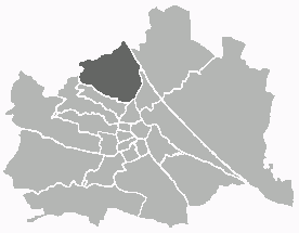
Döbling (German pronunciation: [ˈdøːblɪŋ] ⓘ) is the 19th district in the city of Vienna, Austria (German: 19. Bezirk, Döbling, Doebling). It is located in the north of Vienna, north of the districts Alsergrund and Währing. Döbling has some heavily populated urban areas with many residential buildings, and borders the Vienna Woods. It includes some of the most expensive residential areas such as Grinzing, Sievering, and Neustift am Walde, and is home to many Heurigen taverns. There are some large Gemeindebauten, including Vienna's most famous, the Karl-Marx-Hof.
Döbling is located in the northwest of Vienna and spans the slope of the Wienerwald (Vienna Woods) to the Danube and the Donaukanal (lit. 'Danube Canal') that make up the border of the district in the east. The Danube forms the border between Döbling and the district Floridsdorf, and the Canal forms the border to the district Brigittenau. At the Gürtel Bridge, crossing the Donaukanal, the district border turns southwest and separates Döbling in the south along Gürtel Road (lit. 'Belt Road') from the district Alsergrund. At Schrottenbachgasse the district turns towards the northwest and separates Döbling from the district Währing along the line Währinger Park–Hasenauerstraße–Peter-Jordan-Straße–Starkfriedgasse–Sommerhaidenweg. There is then a short stretch of border to the district Hernals at the edge of Vienna. In the northwest, the district borders on the municipality of Klosterneuburg, Lower Austria.
Nearly 32.6% of the Döbling district area is urban (compared to Vienna citywide as 33.3%). Of this, 85.2% is for housing, whilst only 2.2% of the district is taken up by businesses, which is very low compared to other districts (Vienna 7.6%). With 51.8% of the district green space (48.3% for Vienna), Döbling is the fifth greenest district of Vienna. Agricultural land accounts for 14.9% of district land, with vineyards playing the biggest role around Grinzing, Nußdorf, Sievering, Neustift am Walde, and Salmannsdorf. A further 25.4% of the district is forested, plus 5.3% for meadows, 2.7% for small gardens, 2.5% for parks, and 0.9% as sports and recreational areas. Of the remaining district territory, 11.0% is taken up by transportation and 4.6% by bodies of water. While the proportion of water is higher in relation to the whole city of Vienna, the proportion of transportation is lower.
Since the Vienna Woods make up a large portion of Döbling, numerous forested hills of Vienna are located within the district limits. Many lie on the border with Lower Austria and the neighboring districts. The highest summit is Hermannskogel (542 m, 1778 ft;) with an outlook tower; however, the symbols of Döbling are Kahlenberg (484 m, 1588 ft) with an outlook and a radio mast, and nearby Leopoldsberg (427 m, 1401 ft). Other hills in this region are: Reisenberg, Latisberg, Vogelsangberg, Dreimarkstein, and Nussberg. Besides, there are hills in partially built-up areas in Döbling, such as Hohe Warte in Heiligenstadt, Hungerberg in Grinzing, and Hackenberg in Sievering.
In the district zone, numerous streams originate, but now are mostly canalized or led underground in pipes. Originally they all flowed, with the exception of the Waldbach (forest stream), into the Danube Canal. Because the catchment areas of the streams lie in the sandstone zone of the Viennese forest, the streams can and were able to swell to a multiple of their normal water quantity, leading again and again to destructive flood waters, especially along the Krottenbach. Krottenbach was the most important stream in Döbling, and is now almost entirely led in pipes. In the area behind Billrothstraße Federal Secondary School, it absorbs the Arbesbach (Erbsenbach) stream that runs through Sievering, in its upper reaches still flowing openly until Obersievering.
Nesselbach passes to the Krapfenwaldl openly, before it unites underground with the Reisenbergbach stream in Grinzing. Reisenbergbach stream passes openly until shortly before the center of Grinzing. Almost entirely in the open, the Schreiberbach stream passes up to Nußdorf, as does the Waldbach stream at Kahlenbergerdorf.
The Döblinger Bach stream that originally sprang in the Cottage area and flowed into the Danube Canal at Spittelau has entirely disappeared because its water has been diverted.
Döbling was composed of these formerly independent municipalities:
Döbling
Döbling (German pronunciation: [ˈdøːblɪŋ] ⓘ) is the 19th district in the city of Vienna, Austria (German: 19. Bezirk, Döbling, Doebling). It is located in the north of Vienna, north of the districts Alsergrund and Währing. Döbling has some heavily populated urban areas with many residential buildings, and borders the Vienna Woods. It includes some of the most expensive residential areas such as Grinzing, Sievering, and Neustift am Walde, and is home to many Heurigen taverns. There are some large Gemeindebauten, including Vienna's most famous, the Karl-Marx-Hof.
Döbling is located in the northwest of Vienna and spans the slope of the Wienerwald (Vienna Woods) to the Danube and the Donaukanal (lit. 'Danube Canal') that make up the border of the district in the east. The Danube forms the border between Döbling and the district Floridsdorf, and the Canal forms the border to the district Brigittenau. At the Gürtel Bridge, crossing the Donaukanal, the district border turns southwest and separates Döbling in the south along Gürtel Road (lit. 'Belt Road') from the district Alsergrund. At Schrottenbachgasse the district turns towards the northwest and separates Döbling from the district Währing along the line Währinger Park–Hasenauerstraße–Peter-Jordan-Straße–Starkfriedgasse–Sommerhaidenweg. There is then a short stretch of border to the district Hernals at the edge of Vienna. In the northwest, the district borders on the municipality of Klosterneuburg, Lower Austria.
Nearly 32.6% of the Döbling district area is urban (compared to Vienna citywide as 33.3%). Of this, 85.2% is for housing, whilst only 2.2% of the district is taken up by businesses, which is very low compared to other districts (Vienna 7.6%). With 51.8% of the district green space (48.3% for Vienna), Döbling is the fifth greenest district of Vienna. Agricultural land accounts for 14.9% of district land, with vineyards playing the biggest role around Grinzing, Nußdorf, Sievering, Neustift am Walde, and Salmannsdorf. A further 25.4% of the district is forested, plus 5.3% for meadows, 2.7% for small gardens, 2.5% for parks, and 0.9% as sports and recreational areas. Of the remaining district territory, 11.0% is taken up by transportation and 4.6% by bodies of water. While the proportion of water is higher in relation to the whole city of Vienna, the proportion of transportation is lower.
Since the Vienna Woods make up a large portion of Döbling, numerous forested hills of Vienna are located within the district limits. Many lie on the border with Lower Austria and the neighboring districts. The highest summit is Hermannskogel (542 m, 1778 ft;) with an outlook tower; however, the symbols of Döbling are Kahlenberg (484 m, 1588 ft) with an outlook and a radio mast, and nearby Leopoldsberg (427 m, 1401 ft). Other hills in this region are: Reisenberg, Latisberg, Vogelsangberg, Dreimarkstein, and Nussberg. Besides, there are hills in partially built-up areas in Döbling, such as Hohe Warte in Heiligenstadt, Hungerberg in Grinzing, and Hackenberg in Sievering.
In the district zone, numerous streams originate, but now are mostly canalized or led underground in pipes. Originally they all flowed, with the exception of the Waldbach (forest stream), into the Danube Canal. Because the catchment areas of the streams lie in the sandstone zone of the Viennese forest, the streams can and were able to swell to a multiple of their normal water quantity, leading again and again to destructive flood waters, especially along the Krottenbach. Krottenbach was the most important stream in Döbling, and is now almost entirely led in pipes. In the area behind Billrothstraße Federal Secondary School, it absorbs the Arbesbach (Erbsenbach) stream that runs through Sievering, in its upper reaches still flowing openly until Obersievering.
Nesselbach passes to the Krapfenwaldl openly, before it unites underground with the Reisenbergbach stream in Grinzing. Reisenbergbach stream passes openly until shortly before the center of Grinzing. Almost entirely in the open, the Schreiberbach stream passes up to Nußdorf, as does the Waldbach stream at Kahlenbergerdorf.
The Döblinger Bach stream that originally sprang in the Cottage area and flowed into the Danube Canal at Spittelau has entirely disappeared because its water has been diverted.
Döbling was composed of these formerly independent municipalities:
Recent media
Recent media