Recent from talks
Dniester
Knowledge base stats:
Talk channels stats:
Members stats:
Dniester
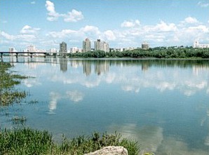
The Dniester (/ˈniːstər/ NEE-stər) is a transboundary river in Eastern Europe. It runs first through Ukraine and then through Moldova (from which it more or less separates the breakaway territory of Transnistria), finally discharging into the Black Sea on Ukrainian territory again.
The name Dniester derives from Sarmatian dānu nazdya "the close river". (The Dnieper, also of Sarmatian origin, derives from the opposite meaning, "the river on the far side".) Alternatively, according to Vasily Abaev Dniester would be a blend of Scythian dānu "river" and Thracian Ister, the previous name of the river, literally Dān-Ister (River Ister). The Ancient Greek name of Dniester, Tyras (Τύρας), is from Scythian tūra, meaning "rapid".[citation needed]
The names of the Don and Danube are also from the same Iranian word *dānu "river". Classical authors have also referred to it as Danaster. These early forms, without -i- but with -a-, contradict Abaev's hypothesis.[citation needed] Edward Gibbon refers to the river both as the Niester and Dniester in his History of the Decline and Fall of the Roman Empire.
In Ukrainian, it is known as Дністе́р (translit. Dnister), in Romanian as Nistru, in Russian as Днестр (translit. Dnestr), in Polish as Dniestr, in Yiddish as Nester נעסטער; in Turkish as Turla (Ottoman Turkish: طورلا ، طورله), and in Lithuanian as Dniestras.
The Dniester rises in Ukraine, near the city of Turka, close to the border with Poland, and flows toward the Black Sea. Its course marks part of the border of Ukraine and Moldova, after which it flows through Moldova for 398 kilometres (247 mi), separating the main territory of Moldova from its breakaway region Transnistria. It later forms an additional part of the Moldova-Ukraine border, then flows through Ukraine to the Black Sea, where its estuary forms the Dniester Liman.
Along the lower half of the Dniester, the western bank is high and hilly while the eastern one is low and flat. The river represents the de facto end of the Eurasian Steppe. Its most important tributaries are Răut and Bîc.
During the Neolithic, the Dniester River was the centre of one of the most advanced civilizations on earth at the time. The Cucuteni–Trypillian culture flourished in this area from roughly 5300 to 2600 BC, leaving behind thousands of archeological sites. Their settlements had up to 15,000 inhabitants, making them among the first large farming communities in the world.
In antiquity, the river was considered one of the principal rivers of European Sarmatia, and it was mentioned by many Classical geographers and historians. According to Herodotus (iv.51) it rose in a large lake, whilst Ptolemy (iii.5.17, 8.1 &c.) places its sources in Mount Carpates (the modern Carpathian Mountains), and Strabo (ii) says that they are unknown. It ran in an easterly direction parallel with the Ister (lower Danube), and formed part of the boundary between Dacia and Sarmatia. It fell into the Pontus Euxinus to the northeast of the mouth of the Ister, the distance between them being 900 stadia – approximately 210 km (130 mi) – according to Strabo (vii.), while 210 km (130 mi) (from the Pseudostoma) according to Pliny (iv. 12. s. 26). Scymnus (Fr. 51) describes it as of easy navigation, and abounding in fish. Ovid (ex Pont. iv.10.50) speaks of its rapid course.
Hub AI
Dniester AI simulator
(@Dniester_simulator)
Dniester
The Dniester (/ˈniːstər/ NEE-stər) is a transboundary river in Eastern Europe. It runs first through Ukraine and then through Moldova (from which it more or less separates the breakaway territory of Transnistria), finally discharging into the Black Sea on Ukrainian territory again.
The name Dniester derives from Sarmatian dānu nazdya "the close river". (The Dnieper, also of Sarmatian origin, derives from the opposite meaning, "the river on the far side".) Alternatively, according to Vasily Abaev Dniester would be a blend of Scythian dānu "river" and Thracian Ister, the previous name of the river, literally Dān-Ister (River Ister). The Ancient Greek name of Dniester, Tyras (Τύρας), is from Scythian tūra, meaning "rapid".[citation needed]
The names of the Don and Danube are also from the same Iranian word *dānu "river". Classical authors have also referred to it as Danaster. These early forms, without -i- but with -a-, contradict Abaev's hypothesis.[citation needed] Edward Gibbon refers to the river both as the Niester and Dniester in his History of the Decline and Fall of the Roman Empire.
In Ukrainian, it is known as Дністе́р (translit. Dnister), in Romanian as Nistru, in Russian as Днестр (translit. Dnestr), in Polish as Dniestr, in Yiddish as Nester נעסטער; in Turkish as Turla (Ottoman Turkish: طورلا ، طورله), and in Lithuanian as Dniestras.
The Dniester rises in Ukraine, near the city of Turka, close to the border with Poland, and flows toward the Black Sea. Its course marks part of the border of Ukraine and Moldova, after which it flows through Moldova for 398 kilometres (247 mi), separating the main territory of Moldova from its breakaway region Transnistria. It later forms an additional part of the Moldova-Ukraine border, then flows through Ukraine to the Black Sea, where its estuary forms the Dniester Liman.
Along the lower half of the Dniester, the western bank is high and hilly while the eastern one is low and flat. The river represents the de facto end of the Eurasian Steppe. Its most important tributaries are Răut and Bîc.
During the Neolithic, the Dniester River was the centre of one of the most advanced civilizations on earth at the time. The Cucuteni–Trypillian culture flourished in this area from roughly 5300 to 2600 BC, leaving behind thousands of archeological sites. Their settlements had up to 15,000 inhabitants, making them among the first large farming communities in the world.
In antiquity, the river was considered one of the principal rivers of European Sarmatia, and it was mentioned by many Classical geographers and historians. According to Herodotus (iv.51) it rose in a large lake, whilst Ptolemy (iii.5.17, 8.1 &c.) places its sources in Mount Carpates (the modern Carpathian Mountains), and Strabo (ii) says that they are unknown. It ran in an easterly direction parallel with the Ister (lower Danube), and formed part of the boundary between Dacia and Sarmatia. It fell into the Pontus Euxinus to the northeast of the mouth of the Ister, the distance between them being 900 stadia – approximately 210 km (130 mi) – according to Strabo (vii.), while 210 km (130 mi) (from the Pseudostoma) according to Pliny (iv. 12. s. 26). Scymnus (Fr. 51) describes it as of easy navigation, and abounding in fish. Ovid (ex Pont. iv.10.50) speaks of its rapid course.
Recent media