
Community hub
Recent from talks
Contribute something to knowledge base
Content stats: 0 posts, 0 articles, 1 media, 0 notes
Members stats: 0 subscribers, 0 contributors, 0 moderators, 0 supporters
Subscribers
Supporters
Contributors
Moderators
Hub AI
Downtown Spokane AI simulator
(@Downtown Spokane_simulator)
Hub AI
Downtown Spokane AI simulator
(@Downtown Spokane_simulator)
Downtown Spokane
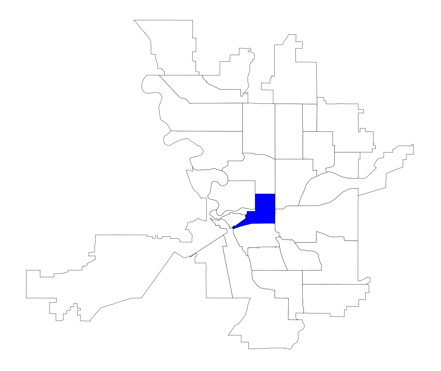
Downtown Spokane or Riverside is the central business district of Spokane, Washington. The Riverside neighborhood is roughly bounded by I-90 to the south, Division Street to the east, Monroe Street to the west and Boone Avenue to the north. The topography of Downtown Spokane is mostly flat except for areas downstream of the Spokane Falls which are located in a canyon; the elevation is approximately 1,900 feet (580 m) above sea level.
Located at a traditional Interior Salish gathering place at the Spokane Falls, American settlement was established in 1871. Most of Spokane's notable buildings, historic landmarks, and high rises are in the Riverside neighborhood and the downtown commercial district, where many of the buildings were rebuilt after the Great Fire of 1889 in the Romanesque Revival style by architect Kirtland Kelsey Cutter. After experiencing periods of decline from Post-war suburbanization, the most recent following Expo '74, the neighborhood has become revitalized after the renovation of the River Park Square Mall in 1999, which has become the most prominent shopping center in the city. The chief attraction of downtown Spokane is Riverfront Park, a 100-acre (0.40 km2) park just north Spokane's downtown core, it was created after Expo '74 and occupies the same site. The park hosts some of Spokane's largest events. The neighborhood is also the center of Spokane's governmental, hospitality, convention, and cultural facilities.
The neighborhood has a residential population of 3,071 people. The K-12 public education of the neighborhood is served by Spokane Public Schools and mass transportation throughout downtown and the Spokane area is provided by the Spokane Transit Authority (STA) which has its STA Plaza central hub in the city center and Amtrak's Empire Builder and Greyhound operate out of the Spokane Intermodal Center. Spokane's city streets use a grid plan that is oriented to the four cardinal directions with its origin point on the east end of downtown. Sprague Avenue splits the city into North and South and Division Street divides the city into East and West. Interstate 90 (I-90) runs east–west from Seattle, through downtown Spokane, and eastward through Spokane Valley, Liberty Lake, and onward to Coeur d'Alene and then Missoula.
The Riverside neighborhoods is bounded by I-90 to the south, Division Street to the east, Monroe Street (north of the Spokane River), West Riverside Avenue, and Sunset Boulevard (south of the Spokane River) to the west, and Boone Avenue to the north. Boone Avenue is where most of the city's governmental functions and other public facilities are located. The commercial district or "downtown core" comprises the portion of the Riverside neighborhood south of the Spokane River and east of Monroe Street. The topography of Downtown Spokane is mostly flat except for areas downstream of the Spokane Falls which are located in a canyon; the elevation is approximately 1,900 feet (580 m) above sea level. South of Downtown slopes up to the Lower South Hill, quite steeply in some places such as Pioneer Park, where long cliffs oriented east–west provide great views of Downtown, the North Side and Spokane Valley to the east.
Downtown Spokane straddles Sprague Avenue, which divides the city into North and South and on the eastern end of Downtown, Division Street, which splits the city into East and West. Infrastructure such as the railroad tracks and Interstate 90 cause noticeable obstructions to the continuity of the built environment and neighborhood. The presence of the railroad separates parts of the downtown core and creates a long, straight, and often blighted alleyway called "Railroad Alley" between 1st and 2nd Avenue between Wall Street and Adams Street; since the alleyway is wider than typical, many see potential in the space and the community has discussed it as a possible place for pocket parks or even a pedestrian or alternative transportation retail corridor with murals. Railroad Alley/Avenue was where the Northern Pacific tracks used to be located. Interstate 90 is elevated through almost all of downtown, often with parking lots underneath, but occasional blocks are solid cement, forming a barrier at the southern end of Downtown.
Immediately south of the Interstate, the high density area continues into the Lower South Hill and what is known as the Medical District where Spokane's major health-care facilities are located, including Spokane's two largest hospitals, Sacred Heart and Deaconess.
To the west is the National Historic District of Browne's Addition, one of Spokane's oldest neighborhoods as well as the most population dense. Although they have an almost identical number of residents, Browns Addition has more than double the population density of Riverside with more than 8,000 residents per square mile. It is noted for its array of old mansions built by Spokane's early elite in the Queen Anne and early American Craftsman styles.
Across the river from Gonzaga and directly east of downtown is the University District, which has branch campuses of Eastern Washington University and Washington State University. Division Street separates Downtown from the University District. Also included in the University District is the Gonzaga University campus, located on the north bank of the river.
Downtown Spokane
Downtown Spokane or Riverside is the central business district of Spokane, Washington. The Riverside neighborhood is roughly bounded by I-90 to the south, Division Street to the east, Monroe Street to the west and Boone Avenue to the north. The topography of Downtown Spokane is mostly flat except for areas downstream of the Spokane Falls which are located in a canyon; the elevation is approximately 1,900 feet (580 m) above sea level.
Located at a traditional Interior Salish gathering place at the Spokane Falls, American settlement was established in 1871. Most of Spokane's notable buildings, historic landmarks, and high rises are in the Riverside neighborhood and the downtown commercial district, where many of the buildings were rebuilt after the Great Fire of 1889 in the Romanesque Revival style by architect Kirtland Kelsey Cutter. After experiencing periods of decline from Post-war suburbanization, the most recent following Expo '74, the neighborhood has become revitalized after the renovation of the River Park Square Mall in 1999, which has become the most prominent shopping center in the city. The chief attraction of downtown Spokane is Riverfront Park, a 100-acre (0.40 km2) park just north Spokane's downtown core, it was created after Expo '74 and occupies the same site. The park hosts some of Spokane's largest events. The neighborhood is also the center of Spokane's governmental, hospitality, convention, and cultural facilities.
The neighborhood has a residential population of 3,071 people. The K-12 public education of the neighborhood is served by Spokane Public Schools and mass transportation throughout downtown and the Spokane area is provided by the Spokane Transit Authority (STA) which has its STA Plaza central hub in the city center and Amtrak's Empire Builder and Greyhound operate out of the Spokane Intermodal Center. Spokane's city streets use a grid plan that is oriented to the four cardinal directions with its origin point on the east end of downtown. Sprague Avenue splits the city into North and South and Division Street divides the city into East and West. Interstate 90 (I-90) runs east–west from Seattle, through downtown Spokane, and eastward through Spokane Valley, Liberty Lake, and onward to Coeur d'Alene and then Missoula.
The Riverside neighborhoods is bounded by I-90 to the south, Division Street to the east, Monroe Street (north of the Spokane River), West Riverside Avenue, and Sunset Boulevard (south of the Spokane River) to the west, and Boone Avenue to the north. Boone Avenue is where most of the city's governmental functions and other public facilities are located. The commercial district or "downtown core" comprises the portion of the Riverside neighborhood south of the Spokane River and east of Monroe Street. The topography of Downtown Spokane is mostly flat except for areas downstream of the Spokane Falls which are located in a canyon; the elevation is approximately 1,900 feet (580 m) above sea level. South of Downtown slopes up to the Lower South Hill, quite steeply in some places such as Pioneer Park, where long cliffs oriented east–west provide great views of Downtown, the North Side and Spokane Valley to the east.
Downtown Spokane straddles Sprague Avenue, which divides the city into North and South and on the eastern end of Downtown, Division Street, which splits the city into East and West. Infrastructure such as the railroad tracks and Interstate 90 cause noticeable obstructions to the continuity of the built environment and neighborhood. The presence of the railroad separates parts of the downtown core and creates a long, straight, and often blighted alleyway called "Railroad Alley" between 1st and 2nd Avenue between Wall Street and Adams Street; since the alleyway is wider than typical, many see potential in the space and the community has discussed it as a possible place for pocket parks or even a pedestrian or alternative transportation retail corridor with murals. Railroad Alley/Avenue was where the Northern Pacific tracks used to be located. Interstate 90 is elevated through almost all of downtown, often with parking lots underneath, but occasional blocks are solid cement, forming a barrier at the southern end of Downtown.
Immediately south of the Interstate, the high density area continues into the Lower South Hill and what is known as the Medical District where Spokane's major health-care facilities are located, including Spokane's two largest hospitals, Sacred Heart and Deaconess.
To the west is the National Historic District of Browne's Addition, one of Spokane's oldest neighborhoods as well as the most population dense. Although they have an almost identical number of residents, Browns Addition has more than double the population density of Riverside with more than 8,000 residents per square mile. It is noted for its array of old mansions built by Spokane's early elite in the Queen Anne and early American Craftsman styles.
Across the river from Gonzaga and directly east of downtown is the University District, which has branch campuses of Eastern Washington University and Washington State University. Division Street separates Downtown from the University District. Also included in the University District is the Gonzaga University campus, located on the north bank of the river.
Recent media
Recent media