
Recent from talks
Finland–Russia border
Knowledge base stats:
Talk channels stats:
Members stats:
Finland–Russia border
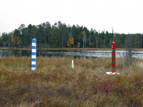
The international border between Finland and Russia is 1,340 km (830 mi) long and runs approximately north to south, mostly through taiga forests and sparsely populated rural areas. It does not follow any natural landmarks, such as mountains or rivers. It is also an external border of the European Union and NATO.
It is patrolled by the Finnish Border Guard and the Border Guard Service of Russia, who also enforce border zones extending, respectively, up to 3 km (1.9 mi) on the Finnish side and at least 7.5 km (4.7 mi) on the Russian side[citation needed]. A permit is required for entry to these border zones. Electronic surveillance on the Finnish side is concentrated most heavily on the southernmost 200 kilometers (125 miles). In addition, the Finnish Border Guard conducts irregularly scheduled dog patrols multiple times daily to catch illegal entries into the border zone. The border can be crossed only at official checkpoints, and at least one visa is required for most people. Major border checkpoints are found in Vaalimaa and Nuijamaa, where customs services on both sides inspect and levy fees on imported goods. In an attempt to curb a sudden increase in asylum seekers entering Finland via Russia, all border crossings were closed in late 2023.
The northern endpoint of the border between Norway, Finland, and Russia forms a tripoint marked by Treriksrøysa, a stone cairn near Muotkavaara (69°03′06″N 28°55′45″E / 69.05167°N 28.92917°E). On the south, the boundary is on the shore of the Gulf of Finland, in which there is a maritime boundary between the respective territorial waters, terminating in a narrow strip of international waters between Finnish and Estonian territorial waters.
The first treaty concerning the border was signed in Nöteborg in 1323 between Sweden (to which Finland belonged) and the Novgorod Republic. The Treaty of Teusina in 1595 moved the border eastward. As a result of the Ingrian War and the resulting Treaty of Stolbovo (1617), Sweden gained a large tract of land through the acquisition of the Nöteborg fortress, Kexholm and its large province, southwest Karelia and the province of Ingria. The Treaty of Nystad in 1721 and the Treaty of Åbo in 1743 moved the border westward.
The population of the border region was marked by religious differences, with the Russian side being predominantly Orthodox, while the Swedish side was initially Catholic, and later, Lutheran Protestant. After the peace of Stolbovo in 1617, the Orthodox population faced persecution and many fled to the Russian side or converted to Lutheranism. The displaced population was largely replaced by immigrants from Finland, most of whom were Savonians who spoke Finnish instead of the closely related Karelian.
After the Finnish War, the Treaty of Fredrikshamn transferred Finland from Sweden to the Russian Empire with the establishment of the Grand Duchy of Finland, an autonomous state ruled by the Russian Emperors. In 1812, the Vyborg Governorate, also known as "Old Finland", was incorporated into the new Grand Duchy.
A customs border was set up between the Grand Duchy and Russia, making Finland its own customs territory. The Finnish Customs Department was officially established on February 18, 1812. The customs border was primarily for Russia's benefit, but it gave Finland the crucial ability to use its own customs revenue and set its own tariffs. By the early 20th century, customs had become the Grand Duchy's most significant source of tax revenue, accounting for about three-quarters of state income. Efforts to unify the Finnish and Russian customs services and remove the border failed due to internal Russian turmoil in the early 1900s.
The first national atlas of Finland, Suomen kartasto, was published during the period of Russification in 1899. On the map, the border with Russia was intentionally drawn in a similar style to the borders with Sweden and Norway to emphasize Finland's distinct status as a separate entity from Russia. The depiction of the border drew attention from the Governor-General of Finland, the Russian representative in Finland, who sent a letter to the Senate and requested that the border between the Grand Duchy and Russia be marked differently from the national borders. In the 1910 edition of the atlas, this request was acknowledged by making a nearly imperceptible change to the width of the lines marking the borders with Sweden and Norway.
Hub AI
Finland–Russia border AI simulator
(@Finland–Russia border_simulator)
Finland–Russia border
The international border between Finland and Russia is 1,340 km (830 mi) long and runs approximately north to south, mostly through taiga forests and sparsely populated rural areas. It does not follow any natural landmarks, such as mountains or rivers. It is also an external border of the European Union and NATO.
It is patrolled by the Finnish Border Guard and the Border Guard Service of Russia, who also enforce border zones extending, respectively, up to 3 km (1.9 mi) on the Finnish side and at least 7.5 km (4.7 mi) on the Russian side[citation needed]. A permit is required for entry to these border zones. Electronic surveillance on the Finnish side is concentrated most heavily on the southernmost 200 kilometers (125 miles). In addition, the Finnish Border Guard conducts irregularly scheduled dog patrols multiple times daily to catch illegal entries into the border zone. The border can be crossed only at official checkpoints, and at least one visa is required for most people. Major border checkpoints are found in Vaalimaa and Nuijamaa, where customs services on both sides inspect and levy fees on imported goods. In an attempt to curb a sudden increase in asylum seekers entering Finland via Russia, all border crossings were closed in late 2023.
The northern endpoint of the border between Norway, Finland, and Russia forms a tripoint marked by Treriksrøysa, a stone cairn near Muotkavaara (69°03′06″N 28°55′45″E / 69.05167°N 28.92917°E). On the south, the boundary is on the shore of the Gulf of Finland, in which there is a maritime boundary between the respective territorial waters, terminating in a narrow strip of international waters between Finnish and Estonian territorial waters.
The first treaty concerning the border was signed in Nöteborg in 1323 between Sweden (to which Finland belonged) and the Novgorod Republic. The Treaty of Teusina in 1595 moved the border eastward. As a result of the Ingrian War and the resulting Treaty of Stolbovo (1617), Sweden gained a large tract of land through the acquisition of the Nöteborg fortress, Kexholm and its large province, southwest Karelia and the province of Ingria. The Treaty of Nystad in 1721 and the Treaty of Åbo in 1743 moved the border westward.
The population of the border region was marked by religious differences, with the Russian side being predominantly Orthodox, while the Swedish side was initially Catholic, and later, Lutheran Protestant. After the peace of Stolbovo in 1617, the Orthodox population faced persecution and many fled to the Russian side or converted to Lutheranism. The displaced population was largely replaced by immigrants from Finland, most of whom were Savonians who spoke Finnish instead of the closely related Karelian.
After the Finnish War, the Treaty of Fredrikshamn transferred Finland from Sweden to the Russian Empire with the establishment of the Grand Duchy of Finland, an autonomous state ruled by the Russian Emperors. In 1812, the Vyborg Governorate, also known as "Old Finland", was incorporated into the new Grand Duchy.
A customs border was set up between the Grand Duchy and Russia, making Finland its own customs territory. The Finnish Customs Department was officially established on February 18, 1812. The customs border was primarily for Russia's benefit, but it gave Finland the crucial ability to use its own customs revenue and set its own tariffs. By the early 20th century, customs had become the Grand Duchy's most significant source of tax revenue, accounting for about three-quarters of state income. Efforts to unify the Finnish and Russian customs services and remove the border failed due to internal Russian turmoil in the early 1900s.
The first national atlas of Finland, Suomen kartasto, was published during the period of Russification in 1899. On the map, the border with Russia was intentionally drawn in a similar style to the borders with Sweden and Norway to emphasize Finland's distinct status as a separate entity from Russia. The depiction of the border drew attention from the Governor-General of Finland, the Russian representative in Finland, who sent a letter to the Senate and requested that the border between the Grand Duchy and Russia be marked differently from the national borders. In the 1910 edition of the atlas, this request was acknowledged by making a nearly imperceptible change to the width of the lines marking the borders with Sweden and Norway.
Recent media