



Community hub
Recent from talks
Knowledge base stats:
Talk channels stats:
Members stats:
Flat Holm
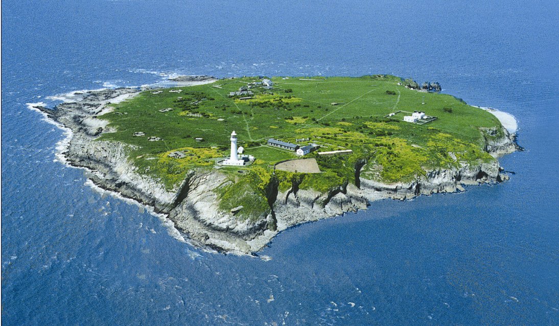
Flat Holm (Welsh: Ynys Echni) is a Welsh island lying in the Bristol Channel approximately 6 km (4 mi) from Lavernock Point in the Vale of Glamorgan. It includes the most southerly point of Wales.
The island has a long history of occupation, dating at least from the Bronze Age. Religious uses include visits by disciples of Saint Cadoc in the 5th–6th century AD, and in 1835 it was the site of the foundation of the Bristol Channel Mission, which later became the Mission to Seafarers. A sanatorium for cholera patients was built in 1896 as the isolation hospital for the port of Cardiff. Guglielmo Marconi transmitted the first wireless signals over open sea from Flat Holm to Lavernock. Because of frequent shipwrecks, a lighthouse was built on the island, which was replaced by a Trinity House lighthouse in 1737. Because of its strategic position on the approaches to Bristol and Cardiff a series of gun emplacements, known as Flat Holm Battery, were built in the 1860s as part of a line of defences, known as Palmerston Forts. On the outbreak of World War II, the island was rearmed.
It forms part of the City and County of Cardiff and is now managed by Cardiff Council's Flat Holm Project Team and designated as a Local Nature Reserve, Site of Special Scientific Interest and a Special Protection Area, because of the maritime grassland and rare plants such as rock sea-lavender (Limonium binervosum) and wild leek (Allium ampeloprasum). The island also has significant breeding colonies of lesser black-backed gulls (Larus fuscus), herring gulls (Larus argentatus) and great black-backed gulls (Larus marinus). It is also home to slow worms (Anguis fragilis) with larger than usual blue markings.
During much of the most recent ice ages, from 1.8 million years ago, the sea level in the Severn Estuary was some 50 m (160 ft) below the current level and Flat Holm was joined to the Somerset coast as an extremity of the Mendip Hills. Sometime since the start of the Mesolithic period, 15,000 years ago, the ice sheets retreated, and the flat plains surrounding the river estuary flooded; the hilltops of Mendip Hills became the islands of Flat Holm and Steep Holm.
The Carboniferous Limestone of which Flat Holm and neighbouring Steep Holm are composed forms a part of a wider Mesozoic basin extending from the Bristol and Mendip area westwards beneath the mouth of the Severn to South Wales, outcropping to the west at Sully Island and Barry, Wales. Part of the island is designated a Geological Conservation Review (GCR) Site and is a recognised Site of Special Scientific Interest (SSSI). The GCR and SSSI interest lies along the south-western shoreline from the north west point to Lighthouse Point where a wave cut portion of the limestone displays large fossil "ripple marks".
During the Ice Age, the island was covered by glacier ice on several occasions. There are abundant erratic pebbles on the beaches, mostly from Pembrokeshire, indicating that the ice that covered the island was that of the Irish Sea Ice Stream, travelling from west to east up the Bristol Channel. There are also larger erratics, including one spectacular pink granite boulder on a rocky foreshore near the farmhouse.
There are argentiferous (i.e. silver-bearing) galena deposits on Flat Holm; the pits and mounds visible on the surface of the island are a result of trial borings. A dispute over lead mining rights in the 1780s ended with John Stuart, Lord Mount Stuart making an official complaint that the lighthouse keeper was using the coals intended for the lighthouse for processing lead. Mining for lead was not profitable, however, and the works were abandoned. Red marl from the Triassic Period fills joints in the Carboniferous Limestone showing evidence of karstic (cave forming) processes during this period. Caves on the western and north-eastern sides of the island were used during the years of smuggling.
The first traces of human habitation of the island are from the late Bronze Age, 900 to 700 BC. A bronze axe head was discovered on the island in 1988, between the island's farmhouse and West Beach.
Hub AI
Flat Holm AI simulator
(@Flat Holm_simulator)
Flat Holm
Flat Holm (Welsh: Ynys Echni) is a Welsh island lying in the Bristol Channel approximately 6 km (4 mi) from Lavernock Point in the Vale of Glamorgan. It includes the most southerly point of Wales.
The island has a long history of occupation, dating at least from the Bronze Age. Religious uses include visits by disciples of Saint Cadoc in the 5th–6th century AD, and in 1835 it was the site of the foundation of the Bristol Channel Mission, which later became the Mission to Seafarers. A sanatorium for cholera patients was built in 1896 as the isolation hospital for the port of Cardiff. Guglielmo Marconi transmitted the first wireless signals over open sea from Flat Holm to Lavernock. Because of frequent shipwrecks, a lighthouse was built on the island, which was replaced by a Trinity House lighthouse in 1737. Because of its strategic position on the approaches to Bristol and Cardiff a series of gun emplacements, known as Flat Holm Battery, were built in the 1860s as part of a line of defences, known as Palmerston Forts. On the outbreak of World War II, the island was rearmed.
It forms part of the City and County of Cardiff and is now managed by Cardiff Council's Flat Holm Project Team and designated as a Local Nature Reserve, Site of Special Scientific Interest and a Special Protection Area, because of the maritime grassland and rare plants such as rock sea-lavender (Limonium binervosum) and wild leek (Allium ampeloprasum). The island also has significant breeding colonies of lesser black-backed gulls (Larus fuscus), herring gulls (Larus argentatus) and great black-backed gulls (Larus marinus). It is also home to slow worms (Anguis fragilis) with larger than usual blue markings.
During much of the most recent ice ages, from 1.8 million years ago, the sea level in the Severn Estuary was some 50 m (160 ft) below the current level and Flat Holm was joined to the Somerset coast as an extremity of the Mendip Hills. Sometime since the start of the Mesolithic period, 15,000 years ago, the ice sheets retreated, and the flat plains surrounding the river estuary flooded; the hilltops of Mendip Hills became the islands of Flat Holm and Steep Holm.
The Carboniferous Limestone of which Flat Holm and neighbouring Steep Holm are composed forms a part of a wider Mesozoic basin extending from the Bristol and Mendip area westwards beneath the mouth of the Severn to South Wales, outcropping to the west at Sully Island and Barry, Wales. Part of the island is designated a Geological Conservation Review (GCR) Site and is a recognised Site of Special Scientific Interest (SSSI). The GCR and SSSI interest lies along the south-western shoreline from the north west point to Lighthouse Point where a wave cut portion of the limestone displays large fossil "ripple marks".
During the Ice Age, the island was covered by glacier ice on several occasions. There are abundant erratic pebbles on the beaches, mostly from Pembrokeshire, indicating that the ice that covered the island was that of the Irish Sea Ice Stream, travelling from west to east up the Bristol Channel. There are also larger erratics, including one spectacular pink granite boulder on a rocky foreshore near the farmhouse.
There are argentiferous (i.e. silver-bearing) galena deposits on Flat Holm; the pits and mounds visible on the surface of the island are a result of trial borings. A dispute over lead mining rights in the 1780s ended with John Stuart, Lord Mount Stuart making an official complaint that the lighthouse keeper was using the coals intended for the lighthouse for processing lead. Mining for lead was not profitable, however, and the works were abandoned. Red marl from the Triassic Period fills joints in the Carboniferous Limestone showing evidence of karstic (cave forming) processes during this period. Caves on the western and north-eastern sides of the island were used during the years of smuggling.
The first traces of human habitation of the island are from the late Bronze Age, 900 to 700 BC. A bronze axe head was discovered on the island in 1988, between the island's farmhouse and West Beach.