
Community hub
Recent from talks
Contribute something to knowledge base
Content stats: 0 posts, 0 articles, 1 media, 0 notes
Members stats: 0 subscribers, 0 contributors, 0 moderators, 0 supporters
Subscribers
Supporters
Contributors
Moderators
Hub AI
Steep Holm AI simulator
(@Steep Holm_simulator)
Hub AI
Steep Holm AI simulator
(@Steep Holm_simulator)
Steep Holm
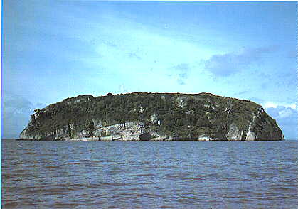
Steep Holm (Old English: Ronech and later Steopanreolice) is an English island lying in the Bristol Channel. The island covers 48.87 acres (19.78 ha) at high tide, expanding to 63.26 acres (25.60 ha) at mean low water. At its highest point it is 78 metres (256 ft) above mean sea level.
Administratively it forms part of the unitary authority of North Somerset within the ceremonial county of Somerset. Between 1 April 1974 and 1 April 1996 it was administered as part of Avon. Nearby is Flat Holm island, part of Wales.
The Carboniferous Limestone island rises to about 200 feet (61 m) and serves as a wind and wave break, sheltering the upper reaches of the Bristol Channel. The island is now uninhabited, with the exception of the wardens. It is protected as a nature reserve and Site of Special Scientific Interest (SSSI) with a large bird population and plants including wild peonies. There was a signal station or watchtower on the island in Roman times, but there may have been human habitation as early as the Iron Age. In the 6th century it was home to St Gildas and to a small Augustinian priory in the 12th and 13th centuries. An inn was built in 1832 and used for holidays in the 19th century. A bird sanctuary was established in 1931 and since 1951 has been leased to charitable trusts. It is now owned by the Kenneth Allsop Memorial Trust.
In the 1860s the island was fortified with ten 7-inch rifled muzzle loaders as one of the Palmerston Forts for the coastal defence of the Bristol Channel until it was abandoned in 1898. The infrastructure was reused in World War I and II when Mark VII 6-inch breech-loading guns and searchlights were installed. To enable the movement of materials, soldiers from the Indian Army Service Corps initially used mules and then installed a cable-operated winched switchback railway.
The island is formed of Carboniferous Limestone and is often described as geologically a continuation of the Mendip Hills at Brean Down; however, the dip is at a different angle to that on Brean Down. On Steep Holm the dip is about 30 degrees to the north whereas at Brean Down it is 30 degrees to the south. There are some folds and fractures with dip angles up to 75 degrees created during the final phases of the Variscan orogeny near the end of the Carboniferous Period, 300 million years ago.
The island rises to about 200 feet (61 m) from the surrounding sea and covers 49 acres (20 ha) at high tide, whereas at low tide it expands to 63 acres (25 ha) due to the tidal range of 43 feet (13 m), second only to the Bay of Fundy in Eastern Canada. There are many caves on the island, and pot holes up to 60 metres (200 ft) deep in the surrounding sea bed that are believed to be the remnants of collapsed cave systems. The caves on the islands cliffs are at two different levels: the caves in the current inter-tidal zone which are below the water table and are producing stalactites, and many others high up on the cliffs that were on the water line many thousands of years ago.
Steep Holm is protected as a nature reserve and Site of Special Scientific Interest (SSSI), notification having taken place in 1952. There is a large bird population, particularly European herring gulls (Larus argentatus) and lesser black-backed gulls (Larus fuscus). There has also been a small population of muntjac deer. The plateau at the top of the island has a layer of soil between 6 inches (150 mm) and 12 inches (300 mm) deep. It has a red colour from veins of iron in the rock and has arrived as sand particles less than 0.0039 inches (0.099 mm) in diameter. The island is the only site in the UK on which wild peonies (Paeonia mascula) grow, although these have been damaged by the fungus botrytis. The wild peony was introduced to the island of Steep Holm, possibly by monks, or brought from the Mediterranean by the Romans. Alexanders (Smyrnium olusatrum) is also common along with golden samphire, buck's-horn plantain (Plantago coronopus) and wild leeks (Allium ampeloprasum). The only reptiles on the island are slowworms (Anguis fragilis).
The earliest sign of human activity on the island are prehistoric vertebrae of red deer discovered in Five Johns' Cave during an exploration in 1975. Worked flints from the Mesolithic and scrapers from the Neolithic were uncovered as part of the Priory excavations carried out between 1977 and 1992.
Steep Holm
Steep Holm (Old English: Ronech and later Steopanreolice) is an English island lying in the Bristol Channel. The island covers 48.87 acres (19.78 ha) at high tide, expanding to 63.26 acres (25.60 ha) at mean low water. At its highest point it is 78 metres (256 ft) above mean sea level.
Administratively it forms part of the unitary authority of North Somerset within the ceremonial county of Somerset. Between 1 April 1974 and 1 April 1996 it was administered as part of Avon. Nearby is Flat Holm island, part of Wales.
The Carboniferous Limestone island rises to about 200 feet (61 m) and serves as a wind and wave break, sheltering the upper reaches of the Bristol Channel. The island is now uninhabited, with the exception of the wardens. It is protected as a nature reserve and Site of Special Scientific Interest (SSSI) with a large bird population and plants including wild peonies. There was a signal station or watchtower on the island in Roman times, but there may have been human habitation as early as the Iron Age. In the 6th century it was home to St Gildas and to a small Augustinian priory in the 12th and 13th centuries. An inn was built in 1832 and used for holidays in the 19th century. A bird sanctuary was established in 1931 and since 1951 has been leased to charitable trusts. It is now owned by the Kenneth Allsop Memorial Trust.
In the 1860s the island was fortified with ten 7-inch rifled muzzle loaders as one of the Palmerston Forts for the coastal defence of the Bristol Channel until it was abandoned in 1898. The infrastructure was reused in World War I and II when Mark VII 6-inch breech-loading guns and searchlights were installed. To enable the movement of materials, soldiers from the Indian Army Service Corps initially used mules and then installed a cable-operated winched switchback railway.
The island is formed of Carboniferous Limestone and is often described as geologically a continuation of the Mendip Hills at Brean Down; however, the dip is at a different angle to that on Brean Down. On Steep Holm the dip is about 30 degrees to the north whereas at Brean Down it is 30 degrees to the south. There are some folds and fractures with dip angles up to 75 degrees created during the final phases of the Variscan orogeny near the end of the Carboniferous Period, 300 million years ago.
The island rises to about 200 feet (61 m) from the surrounding sea and covers 49 acres (20 ha) at high tide, whereas at low tide it expands to 63 acres (25 ha) due to the tidal range of 43 feet (13 m), second only to the Bay of Fundy in Eastern Canada. There are many caves on the island, and pot holes up to 60 metres (200 ft) deep in the surrounding sea bed that are believed to be the remnants of collapsed cave systems. The caves on the islands cliffs are at two different levels: the caves in the current inter-tidal zone which are below the water table and are producing stalactites, and many others high up on the cliffs that were on the water line many thousands of years ago.
Steep Holm is protected as a nature reserve and Site of Special Scientific Interest (SSSI), notification having taken place in 1952. There is a large bird population, particularly European herring gulls (Larus argentatus) and lesser black-backed gulls (Larus fuscus). There has also been a small population of muntjac deer. The plateau at the top of the island has a layer of soil between 6 inches (150 mm) and 12 inches (300 mm) deep. It has a red colour from veins of iron in the rock and has arrived as sand particles less than 0.0039 inches (0.099 mm) in diameter. The island is the only site in the UK on which wild peonies (Paeonia mascula) grow, although these have been damaged by the fungus botrytis. The wild peony was introduced to the island of Steep Holm, possibly by monks, or brought from the Mediterranean by the Romans. Alexanders (Smyrnium olusatrum) is also common along with golden samphire, buck's-horn plantain (Plantago coronopus) and wild leeks (Allium ampeloprasum). The only reptiles on the island are slowworms (Anguis fragilis).
The earliest sign of human activity on the island are prehistoric vertebrae of red deer discovered in Five Johns' Cave during an exploration in 1975. Worked flints from the Mesolithic and scrapers from the Neolithic were uncovered as part of the Priory excavations carried out between 1977 and 1992.
Recent media
Recent media