
Community hub
Recent from talks
Contribute something to knowledge base
Content stats: 0 posts, 0 articles, 1 media, 0 notes
Members stats: 0 subscribers, 0 contributors, 0 moderators, 0 supporters
Subscribers
Supporters
Contributors
Moderators
Hub AI
Flathead Lake AI simulator
(@Flathead Lake_simulator)
Hub AI
Flathead Lake AI simulator
(@Flathead Lake_simulator)
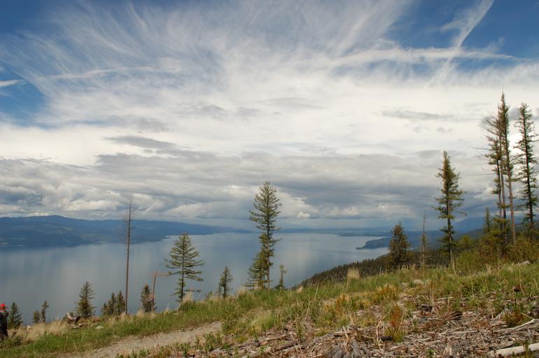
Flathead Lake
Flathead Lake (Salish: člq̓etkʷ, Kutenai: yawuʔnik̓ ʔa·kuq̓nuk) is a large natural lake in northwest Montana, United States.
The lake is a remnant of the ancient, massive glacial dammed lake, Lake Missoula, of the era of the last interglacial. Flathead Lake is a natural lake along the mainline of the Flathead River. It was dammed in 1930 by Kerr Dam at its outlet on Polson Bay, slightly raising the lake level; the dam generates electricity. The hydroelectric has been owned and operated by the Confederated Salish and Kootenai Tribes since 2015. It is one of the cleanest lakes in the populated world for its size and type.
Located in the northwest corner of the state of Montana, 7 miles (11 km) south of Kalispell, Flathead Lake is approximately 30 miles (48 km) long and 16 miles (26 km) wide, covering 197 square miles (510 km2). It is a similar size to Minnesota's Mille Lacs Lake, but smaller than Red Lake. It is about half the area of San Francisco Bay (main bay). It is larger in surface area than Lake Tahoe but much smaller in volume due to Tahoe's depth. Flathead Lake has a maximum depth of 370.7 ft (113.0 m), and an average of 164.7 ft (50.2 m). This makes Flathead Lake deeper than the average depths of the Yellow Sea or the Persian Gulf. Flathead Lake is in a scenic part of Montana, 30 miles (48 km) southwest of Glacier National Park, and is flanked by two scenic highways, which wind along its curving shoreline. On the west side is U.S. Route 93, and on the east, is Route 35.
The lake is bordered on its eastern shore by the Mission Mountains and on the west by the Salish Mountains. The Flathead valley was formed by the glacial damming of the Flathead River and sustains a remarkably mild climate for a region located this far north and inland; the Pacific Ocean is almost 400 miles (640 km) to the west. The mild climate allows for cherry orchards on the east shore and vineyards for wine production on the west shore. There are also apple, pear and plum orchards around the lake as well as vegetables, hay, honey, nursery tree, Christmas tree, sod/turf, and wheat production bordering or near the lake.
The lake has an irregularly shaped shoreline and a dozen small islands cover 5.5 square miles (14 km2). Wild Horse Island is the largest island at 2,164 acres (876 ha). Melita Island is a 64-acre (260,000 m2) island on Flathead Lake, located about one-half mile off the west lakeshore. At its highest point Melita is 80 feet (24 m) above water level. The island is owned by the Montana Council of the Boy Scouts of America. It is home to Camp Melita Island and is used and for other activities; there is a project for woodland rehabilitation run by the Montana Council. There is also a bald eagle reserve which is protected by the Native Americans. Boy Scouts began using the island in the 1940s.
Flathead Lake lies at the southern end of a geological feature called the Rocky Mountain Trench. The trench, which formed with the Rocky Mountains, extends north into the southern Yukon as a straight, steep valley, which also holds the headwaters of the Columbia River. During the last ice age this trench was filled by an enormous glacier. As the glacier moved southward it carved out the trench. The Polson Moraine, near present-day Polson, Montana, marks the southernmost extent of the glacier during the last ice age and thus is the site of the glacier's terminal moraine.
The large size of the Polson Moraine indicates that the glacier stalled here for many years before retreating. As the climate warmed, a portion of the glacier in the Mission Valley receded more slowly than the main body, which kept the lake basin from being filled with sediment. Eventually this ice also melted, forming a lake behind the moraine. Once the water reached the top of this moraine dam, it began to cut a channel through it. Most moraine dammed lakes drain quickly because water cuts entirely through the moraine. Flathead Lake remained because a bedrock hill buried underneath the Polson Moraine prevented the moraine from being completely cut through so the meltwater never completely drained.
At one time, probably when the valley was partially filled by a glacier, the level of Flathead Lake was about 500 feet (150 m) higher and drained through the valley west of Elmo, Montana, which is at the end of Big Arm Bay, bottom center in the aerial photo above. Water carved out a wide, flat-bottomed pass with a deeper, narrow channel at the south edge of the pass. The deeper channel and traces of the dry riverbed are still visible from Route 28.[citation needed]
Recent media
Recent media